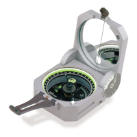
P O C K E T
T R A N S I T
INSTRUCTION MANUAL
1 – IMPORTANT INFORMATION ................................................ Page(s): 1
2 – ORIENTATION ...................................................................................... 2
3 – MAGNETIC DECLINATION ................................................................... 4
4 – AZIMUTH MEASUREMENT ................................................................ 6
5 – VERTICAL & PERCENT GRADE MEASUREMENT ............................. 9
6 – COMPASS USE WITH A TOPOGRAPHIC MAP .................................. 12
7 – ADDITIONAL MEASUREMENT ......................................................... 13
8 – PROSPECTING ................................................................................... 14
9 – REFERENCE MATERIAL .................................................................... 20
10 – SPECIFICATIONS ............................................................................. 21
11 – SERVICE ............................................................................................ 22
i
Copyright 2000, The Brunton Company
A subsidiary of Silva Production, AB
Printed in U.S.A.
form 51-600 rev 0011
Owner’s Purchase Record
Model _______________________________________________________
Date of Purchase ______________________________________________
Dealer Purchased From: _________________________________________
_____________________________________________________________
Serial #: