Return to home
YC.BZ.S00249
Appendix
●
Aircraft (Model: T600)
Weight 2870 g (Battery and Propellers Included, Zenmuse X5 Excluded)
Weight 3400 g (Battery, Propellers and Zenmuse X5 Included)
Maximum Weight of Payload 3400 g
Max Tilt Angle 35°
Max Ascent Speed 5 m/s
Max Descent Speed 4 m/s
Max Speed 18 m/s (ATTI mode, no wind)
Max Altitude Above Sea Level 14,700 feet (4,500 meters)
Max Flight Time Approximately 15 minutes
Operating Temperature Range 14° to 104° F (-10° to 40° C)
●
Gimbal
Angular Vibration Range ±0.02°
Controllable Range Pitch: -90° to +30° Pan: ±320°
Max Controllable Speed Pitch: 120°/s Pan: 180°/s
●
Vision Positioning System
Velocity Range <8 m/s @Altitude 6.56 feet (2 m)
Altitude Range 0.16 feet - 16.4 feet (5 cm-500 cm)
Operating Range <9.84 feet (<300 cm)
Operating Environment Surface with clear pattern and adequate lighting (>15 Lux)
●
Camera (Name/Model: ZENMUSE X5/FC550)
Sensor Type 4/3 CMOS sensor Effective pixels: 16M
Lens DJI MFT 15mm f/1.7 ASPH (FOV72° 35 mm format equivalent 30 mm)
ISO Range 100-25600
Electronic Shutter Speed 8 s-1/8000 s
Image Max Size 4608×3456
Still Photography Modes Single shoot; Burst shooting: 3/5/7 frames
Auto Exposure Bracketing (AEB): 3/5 bracketed frames at 0.7EV Bias; Time-lapse
Video Resolution UHD: 4K (4096×2160) 24/25p, 4K (3840×2160) 24/25/30p, 2.7K (2704×1520) 24/25/30p
FHD: 1920×1080 24/25/30/48/50/60p
Max Bitrate Of Video Storage 60 Mbps
Supported File Systems FAT32 (≤ 32 GB), exFAT (> 32 GB)
Photo Formats JPEG, DNG
VideoFormats MP4/MOV (MPEG-4 AVC/H.264)
Supported SD Card Types Micro SD, Max capacity: 64GB. Class 10 or UHS-1 rating required
Operating Temperature Range 32° to 104° F (0° to 40° C)
●
Remote Controller (Name: C1)
Operating Frequency 922.7 MHz-927.7 MHz (Japan only) 5.725 GHz-5.825 GHz 2.400 GHz-2.483 GHz
Transmitting Distance 6,561 feet (2,000 meters) (outdoor and unobstructed)
Video Output Port USB, Mini-HDMI
Operating Temperature Range 14° to 104° F (-10° to 40° C)
Battery 6000 mAh LiPo 2S
●
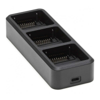
Charger (Model: A14-100P1A)
Voltage 26.3 V
Rated Power 100 W
●
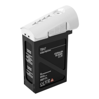
Intelligent Flight Battery (Model: TB47, Standard)
Capacity 4500 mAh
Voltage 22.2 V
Battery Type LiPo 6S High voltage battery
Energy 99.9 Wh
Net Weight 570 g
Operating Temge 14° to 104° F (-10° to 40° C)
Max Charging Power 180 W
●
Intelligent Flight Battery (Model: TB48, Optional)
Capacity 5700 mAh
Voltage 22.8 V
Battery Type LiPo 6S High voltage battery
Energy 129.6 Wh
Net Weight 670 g
Operating Temge 14° to 104° F (-10° to 40° C)
Max Charging Power 180 W
7
.1
6 inc
h
6
.
77
in
c
h
4.14 inch
2.80 inch
FCC ID: SS3-WM6101410 FCC ID: SS3-GL6581502
This device complies with part 15 of the FCC Rules.
Operation is subject to the following two conditions:
(1) This device may not cause harmful interference, and
(2) this device must accept any interference received, including interference
that may cause undesired operation.
※ This Quick Start Guide is subject to change without prior notice.
Vision Positioning
Altitude 3 m
●
Calibrating the Compass:
Make sure to calibrate the compass in every new flight location. The compass is very sensitive to electromagnetic interference,
which can cause abnormal compass data leading to poor flight performance or even failure. Regular calibration is required for
optimum performance.
●
DO NOT calibrate your compass where there is a chance of strong magnetic interference, such as magnetite, parking
structures, and steel reinforcements underground.
●
DO NOT carry ferromagnetic materials with you during calibration such as keys or cellular phones.
●
DO NOT calibrate beside massive metal objects.
●
If it is blinking red and yellow alternately after placing the aircraft on the ground, the compass has detected magnetic
interference. Change your location.
Always
fly under
400 ft
1
7
.7
6
i
nc
h
12.44 inch
17.24 inch
●
The aircraft cannot avoid obstacles during the Failsafe RTH, but user can regain control of the aircraft when signal transmission is resumed;
therefore it is important to set an appropriate Failsafe altitude before each flight. Be sure fly higher than any tall buildings to avoid crashing.
●
P Mode:
In this mode, the Inspire 1 Pro has a strong GPS signal and can use
the VPS allowing it to hover accurately in position indoors and out.
If outdoors, this mode also means that a Home Point has been
locked so that it can Return to Home if the control signal is lost.
There are three states in P mode.
P-GPS: GPS works best when outdoors in a wide open area, and
your Inspire 1 Pro uses GPS to hover in place when the GPS
signal is strong. P-OPTI: If GPS is not available, the aircraft can
use the VPS to hover accurately. P-ATTI: Neither GPS or VPS
available, aircraft is using only its barometer for positioning, so only
altitude is controlled. Note that the VPS may not work properly
when the Inspire 1 Pro is flying over water, over surfaces without a
clear pattern, or in a low light environment.
If you are not in this mode, toggle the Flight Mode
Switch to P position to enable it.
The Flight Mode Switch is locked in P mode by default.
Refer to the User Manual on how to unlock the switch.
●
Return to Home:
When the GPS signal is strong, the aircraft will be
able to record a Home Point and return to the Home
Point when needed. The GPS location is recorded
when the GPS signal icon in the DJI GO app is either
yellow or green.
The aircraft will return to the Home Point automatically in
the following cases (all require a strong GPS signal).
Smart RTH: When you press the RTH button on the
remote controller or in the App. Low Battery RTH: The
DJI GO app notifies users to take action when the
battery level falls to a specified threshold.
Failsafe RTH: When the remote controller signal is lost.
DO NOT FLY in rain, snow, fog, and wind
speeds exceeding 22 mph or 10 m/s.
It is important to understand basic
flight guidelines, for the safety of
both you and those around you.
Refer to the Safety Guidelines and
Disclaimer for more information.
DO NOT FLY near or above people, near
trees, power lines or buildings.
More information at:
http://flysafe.dji.com/no-fly
No Fly Zones
DO MONITOR YOUR ALTITUDE
and fly under 400 feet
(120 meters).
DO MAINTAIN LINE OF SIGHT
and avoid flying behind buildings
or obstacles that block your view.
DJI encourages you to enjoy flying in a safe, responsible and smart way.
●
Be very careful when flying 14,700 feet (4,500 meters) or more above sea level as the battery and aircraft performance may be reduced.
●
The Inspire 1 Pro’s compass and GPS will not work in Polar Regions. The aircraft will auto switch to ATTI Mode and use the VPS for positioning.
GPS Positioning
INSPIRE 1
PRO
11. Gimbal Dial
12. Camera Settings Dial
13. Video Recording Button
14. Flight Mode Switch
15. Shutter Button
16. Playback Button
17. Mini-HDMI Port
18. Micro-USB Port
19. CAN-Bus Port
20. USB Port
21. Back Buttons (Reserved)
10
4
9
9
8
4
5
6
1
3
7
2
21
17 18 19
20
11
14
13
12
1615
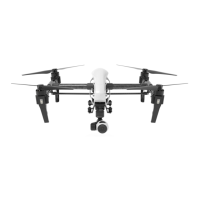
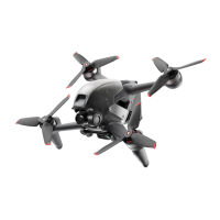
The Inspire 1 Pro is a professional aerial filmmaking and photography platform that is ready to fly right out of the box.
Featuring an onboard camera equipped with a 15mm f/1.7 (35 mm format equivalent 30 mm) lens and 3-axis stabilized
gimbal, it shoots sharp 16mp stills and stable video at up to 4K. Its retractable landing gear pulls up out of view, giving
the camera an unobstructed 360 degree view of the world below.
An advanced flight controller makes the Inspire 1 Pro stable, safe and easy to fly indoors or out. The brand new Vision
Positioning System (VPS) gives it the power to hover in position at low altitudes even without GPS. Like all DJI flight
controllers, it is also able to return home if remote controller signal is lost or if the low battery warning is triggered.
The Inspire 1 Pro boasts a maximum flight speed 18m/s* and a maximum flight time of 15 minutes* using one fully charged
4500mAh Intelligent Flight Battery.
The maximum transmission distance of the Inspire 1 Pro remote controller is 2km*. The remote controller also allows you to
control the landing gear or activate Return to Home with a tap. Other buttons allow instant photo capture, video recording,
picture review and gimbal control.
A DJI Lightbridge-based HD video downlink is built-in, letting you see what your camera sees on your mobile device in
real time HD. The app also allows you to change camera settings and activate Master/Slave mode so that one person
can fly while other controls the gimbal independently. The master and slave controllers communicate using a 5.8Ghz
wireless signal, and have a communication range with each other of up to 50 meters.The controller’s LiPo battery has
a maximum run time of approximately four hours and can be charged by plugging directly into the controller.
1. Power Button
2. Transformation Switch
3. Return to Home (RTH) Button
4. Control Sticks
5. Status LED
6. Battery Level LEDs
7. Power Port
8. Mobile Device Holder
9. Antennas
10. Handle Bar
* The maximum flight speed and maximum run time (hovering state) were tested in a lab environment, at zero-level elevation and in windless conditions, and
should be taken as reference only.
* Please note that the max transmission distance were tested in a lab environment. This statistic is for reference only, as conditions in your area may vary.
INSPIRE 1 PRO Remote Controller
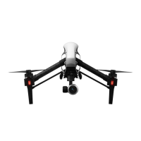
Folded
Landing Mode
Travel Mode
Flight Mode
Landing
Gear Up
Landing Gear Down
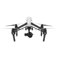
1. Gimbal and Camera
2. Gimbal Lock
3. Vision Positioning System
4. Transformation Mechanism
5. Front LEDs
6. Motors
7. Propellers
8. Rear LEDs
9. Intelligent Flight Battery
10. Power Button
11. Battery Level Indicators
12. Aircraft Status Indicator
13. Aircraft Micro-USB Port
14. Camera Micro-USB Port
15. Camera Micro-SD Slot
16. Lens Release Button
17. AF/MF Switch
Connect to the
mobile device
Fly Safe
21
Quick Start Guide
V1.0
10
11
12
13
6
1
3
2
5
9
5
8
6
6
7
7
7
15
14
4
16
17