dž
-
3
dž
»
- ) - b - ) , b , -
3
' ) p - / p
- ,
Ó
. , - p ) )
3 0
b -
Ó
)
, b - ,
3
' p ) ) - , - , p b -
3
dž
6OBWPMUBDPNQMFUBUBMhPQFSB[JPOFJMWFMJWPMPSJUPSOFSËBVUPNBUJDBNFOUFBMMBQPTJ[JPOFJOJ[JBMF*OWFDFEFMMhPQFSB[JPOF
35)JMWFMJWPMPQVÛFTTFSFBODIFJNQPTUBUPQFSFTFHVJSFBMUSFB[JPOJEJWPMPBMMhJOUFSOPEFMMhBQQ
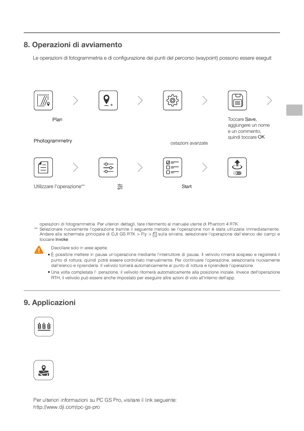
3LVWLYHaPVUPKPMV[VNYHTTL[YPHLKPJVUÄN\YHaPVULKLPW\U[PKLSWLYJVYZV^H`WVPU[WVZZVUVLZZLYLLZLN\P[L
utilizzando il software PC GS Pro e l'applicazione DJI GS RTK. Nel seguente esempio sono riportate le istruzioni
per l’esecuzione di una fotogrammetria utilizzando l'applicazione DJI GS RTK. Per informazioni dettagliate, fare
riferimento al manuale utente di PC GS Pro (se in uso).
3LDQLðFD]LRQHGHOFDPSR
Importare le foto aeree in PC GS Pro per eseguire la post-elaborazione della mappa. Quindi
WPHUPÄJHYLPSJHTWVPU7*.:7YV<[PSPaaHYL\UHZJOLKHTPJYV:+WLYPTWVY[HYLPSÄSLKLSWPHUVKH
PC GS Pro nel dispositivo di controllo remoto della serie Agras MG-1S avanzata/MG-1P. Per ulteriori
dettagli, fare riferimento al manuale utente corrispondente.
0DSSDWXUDDHOHYDWDSUHFLVLRQH
Importare le foto aeree originali in PC GS Pro ed eseguire la post-elaborazione della mappa per
produrre una mappa ad alta precisione. Per maggiori dettagli, fare riferimento al manuale dell'utente
di PC GS Pro.
(MJVUFOUJQPTTPOPJNQPSUBSFBODIFGJMF,.-,.; OFMMhBQQMJDB[JPOFUSBNJUFVOBTDIFEBNJDSP4%QFSQJBOJGJDBSFMF
- , 2 / ) )
3 0
, /
Ó
2 2 ) ) ,
0
c )
Ô
$ %
Õ
3
+ ) b - ) / ) , b -
1
) ) , )
3
w , c ) - - , & ' * + $ %
Õ
t
`
¼ t
Ó
b - , b , ) -
½ ¾ ¿ À Á Â
3
Ã
Ä
Ä
Ã
¢
Ã
Å Ä Æ
Ç
Æ È È É É É Ê È
Ë Ë
Toccare
Ì
Í
nella schermata
principale, selezionare
Ì Î
£ ¤
Ï Ï
¡ £ ¤
Ð
*
Far scorrere il
cursore per iniziare
l'operazione
Toccare
Ä
» ¬ ² »
Toccare in
Camera View per le
impostazioni della
fotocamera
Toccare la mappa per
aggiungere punti di
IVYKV"[YHZJPUHYLWLY
regolarne le posizioni
Impostazioni: altitudine,
]LSVJP[nHaPVULKP
completamento,
telecamera e
impostazioni avanzate
Toccare
Ä
¬ Å ª
,
aggiungere un nome
e un commento,
quindi toccare
Æ Ç
Utilizzare l'operazione**
 Loading...