Do you have a question about the dji Phantom 4 RTK and is the answer not in the manual?
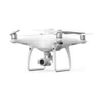
Overview of the Phantom 4 RTK's mapping capabilities and core components.
Details on the Phantom 4 RTK's advanced features, including D-RTK, obstacle avoidance, and camera system.
Steps for preparing the aircraft, including removing gimbal clamp and attaching propellers.
Description of the Phantom 4 RTK aircraft's main components like flight controller and battery.
Explanation of P-mode (Positioning) and A-mode (Attitude) flight modes and their usage.
Explanation of aircraft status indicators and LEDs, detailing their meanings and states.
Details on the RTH function, including types, updating Home Point, and failsafe procedures.
Overview of using the Phantom 4 RTK for industrial tasks like photogrammetry and power line inspections.
Description of the aircraft's vision and infrared sensing systems for obstacle avoidance and positioning.
Explanation of the built-in D-RTK for precise positioning and how to enable/disable RTK.
Instructions and safety precautions for attaching and detaching propellers to the aircraft.
Details on the battery's capacity, voltage, functions, and safety guidelines for operation.
Overview of the remote controller's transmission range, OcuSync, and display features.
Instructions on turning the remote controller on/off and its backup battery functionality.
Steps for charging the remote controller's intelligent battery using AC adapter and charging hub.
How to use the Gimbal Dial, Video Recording Button, and Shutter Button for camera functions.
Explanation of aircraft control modes (Mode 1, 2, 3) and stick operations via the remote controller.
Details on the RTH button function and optimal transmission range for reliable signal.
Explanation of the Status LED and RTH LED indicators on the remote controller for status monitoring.
Procedure for linking the remote controller to the aircraft, including single and multi-aircraft linking.
Enabling and using the Multi-Aircraft Control function to coordinate up to five aircraft.
Overview of the main screen interface, including Plan, Fly, connection status, and menu options.
Guide to planning photogrammetry missions, including map settings, parameters, and advanced options.
Instructions for planning waypoint flights, including setting waypoints, route settings, and saving operations.
Detailed explanation of the Camera View interface, including RTK status, battery level, and control options.
Guidelines for safe flight conditions, including weather, terrain, and electromagnetic interference.
Overview of DJI's GEO system for real-time airspace information and regional flight restrictions.
Definitions of various GEO Zones (Warning, Authorization, Altitude, Restricted) and their implications.
Explanation of default flight restrictions including altitude, distance limits, and GEO Zones.
Detailed restrictions for different GEO Zones like Restricted, Authorization, and Altitude Zones.
Methods for unlocking GEO Zones, including Self-Unlocking and Custom Unlocking.
Essential checks to perform before each flight for safety and operational readiness.
Procedures and rules for calibrating the aircraft's compass to ensure accurate navigation.
Instructions on how to start and stop the aircraft's motors using the CSC command.
Steps for performing a flight test, including takeoff, landing, and basic flight operations.
Technical specifications for the aircraft, including weight, dimensions, speed, and environmental limits.
Technical details on gimbal, vision system, infrared system, and camera specifications.
Detailed specifications for the camera, remote controller, and intelligent flight battery.
Instructions for updating the firmware of the aircraft and remote controller using DJI Assistant 2 and the GS RTK app.
| Type | Quadcopter |
|---|---|
| Product color | White |
| Construction type | Ready-to-fly (RTF) |
| Suitable for outdoor use | Yes |
| Maximum speed | 16.1 m/s |
| Frequency band | 2.4 - 2.483 GHz |
| Number of rotors | - rotors |
| Maximum flight time | 30 min |
| Maximum ascent speed | 6 m/s |
| Maximum descent speed | 3 m/s |
| Maximum weight capacity | - kg |
| Horizontal hover accuracy | 0.1 m |
| Maximum operating distance | - m |
| Megapixel | 20 MP |
| Sensor type | CMOS |
| Maximum frame rate | 30 fps |
| Camera shutter speed | 8 - 1/8000 s |
| Image formats supported | JPEG |
| Video formats supported | H.264 |
| Maximum image resolution | 5472 x 3648 pixels |
| Maximum video resolution | 3840 x 2160 pixels |
| Field of view (FOV) angle | 84 ° |
| Built-in processor | - |
| Compatible memory cards | MicroSD (TransFlash) |
| Maximum memory card size | 128 GB |
| Number of waypoints | 199 |
| Moving control functions | Downward, Forward |
| Operating frequency | 2400 - 2483/5725 - 5850 MHz |
| Battery voltage | 15.2 V |
| Battery capacity | 5870 mAh |
| Transmitter battery capacity | 6000 mAh |
| Output power | 160 W |
| Operating temperature (T-T) | 0 - 40 °C |
| Cables included | AC, Micro-USB, USB Type-C |
| Memory card included | MicroSD |
| Included memory card size | 16 GB |
| Battery weight | 468 g |
|---|