6
©
2018 DJI All Rights Reserved.
Product Prole
Introduction
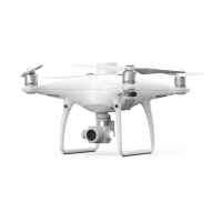
The Phantom 4 RTK is a smart mapping and imaging drone capable of highly accurate mapping functions.
The aircraft has a built-in DJI Onboard D-RTK
TM
, which provides precision data for centimeter-level
positioning accuracy*. Multi-directional obstacle sensing achieved through vision and infrared sensors
enables intelligent obstacle avoidance during flight and indoor hovering and flight. The Phantom 4 RTK
records videos at 4K and captures 20 megapixel photos. The OCUSYNC
TM
HD video downlink built into
both the aircraft and remote controller ensures a reliable and stable transmission.
Features Highlights
The Phantom 4 RTK aircraft has a built-in DJI Onboard D-RTK, providing high-precision data for centimeter-
level positioning when used with Network RTK service or a DJI D-RTK 2. Raw satellite observations and
exposure event records can be used for post-processed kinematic (PPK) dierential corrections.
The Phantom 4 RTK can hover and y in extremely low altitude and indoor environments, and provides
multi-directional obstacle sensing and vision positioning functions. Obstacles detection and avoidance in
large range and landing protection enhance ight safety.
The Phantom 4 RTK is equipped with a 24 mm (35 mm format equivalent) wide angle camera, high-
precision and anti-shake gimbal, 1-inch CMOS sensor, mechanical shutter to oer the best in aerial photo
analysis.
Built into the remote controller is the latest DJI OcuSync technology with enhanced anti-interference
capability to deliver a more stable and smoother video downlink. When combined with the receiver in
the aircraft, the remote controller has a transmission range up to 4.3 mi / 7 km (FCC-compliant version).
The remote controller is equipped with a 5.5-inch high luminance monitor, and an integrated DJI GS RTK
App for real-time HD display. Users can plan ight paths and perform ight operations in the app for both
photogrammetry and waypoint ights. For photogrammetry operations, simply tap on the map in the app to
set a ight area. For waypoint operations, y the aircraft to set waypoints and congure waypoint actions,
then the aircraft will be able to perform automated operations.
The remote controller’s Multi-Aircraft Control mode can be used to coordinate the operation of up to ve
aircraft at the same time, enabling pilots to work very eciently.
Image data from the Phantom 4 RTK can be used to generate maps for eld planning when operating a DJI
AGRASTM aircraft. Users can also import photos to the DJI PC GS Pro application or third-party mapping
software to composite highly accurate maps for dierent applications.
* This should be used with Network RTK service, a DJI D-RTK 2 High-Precision GNSS Mobile Station (purchased
additionally) or post-processed kinematic (PPK) data (recommended when RTK signal is weak during operation).
Installation
Preparing the Aircraft
1. Remove the gimbal clamp from the camera as shown below: