EasyManuals Logo

dji Phantom 4 RTK Quick Start Guide

dji Phantom 4 RTK
35 pages
To Next Page IconTo Next Page
To Previous Page IconTo Previous Page
Page #8 background imageLoading...
Page #8 background image
7
dž
u
& + + % )
dž
t % % & " ) + %
+ ( & ) % + (
( ) + ( & % ( % )
dž
+ ( ( & % ( % ) +
BJSDSBGUDBOBMTPCFTFUUPQFSGPSNPUIFSnJHIUBDUJPOTXJUIJOUIFBQQ
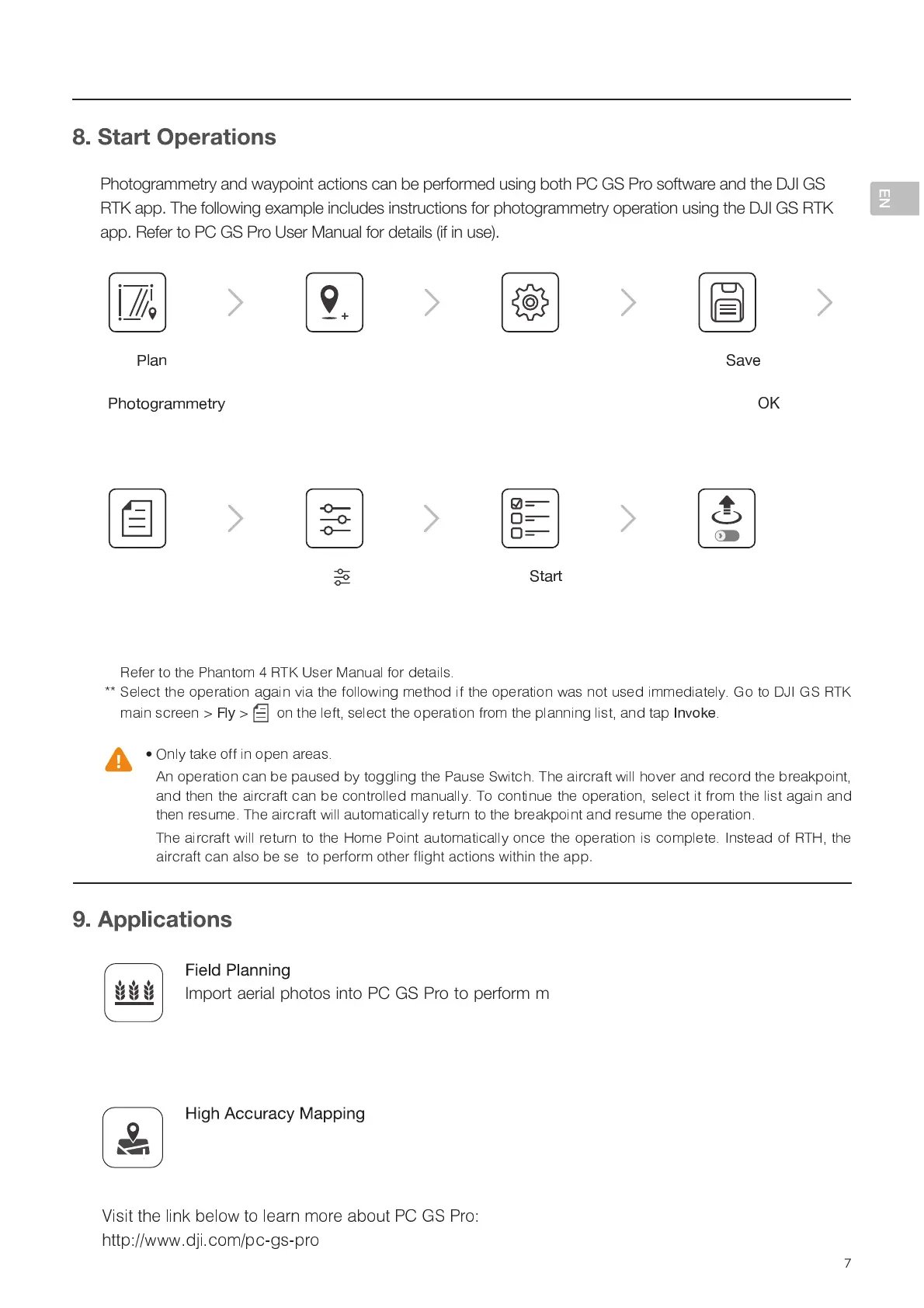
Photogrammetry and waypoint actions can be performed using both PC GS Pro software and the DJI GS
RTK app. The following example includes instructions for photogrammetry operation using the DJI GS RTK
app. Refer to PC GS Pro User Manual for details (if in use).
0TWVY[HLYPHSWOV[VZPU[V7*.:7YV[VWLYMVYTTHWWVZ[WYVJLZZPUN;OLUWSHU[OLÄLSKPU
7*.:7YV<ZLHTPJYV:+JHYK[VPTWVY[[OLWSHUÄSLMYVT7*.:7YVPU[V[OL(NYHZ4.
1S Advanced / MG-1P series remote controller. Refer to corresponding user manuals for
more details.
Import the original aerial photos into PC GS Pro and perform map post-processing to
produce a high-accuracy map. Please refer to the PC GS Pro User Manual for more details.
 6TFSTDBOBMTPJNQPSU,.-,.;mMFTUPUIFBQQUISPVHIBNJDSP4%DBSEUPQMBOQIPUPHSBNNFUSZPQFSBUJPOT
+ ( i v # + )
" % + ( + % ( ( & ) ! ! "
( y ì í î y + % + ( % % ï
ð ~ {
)
ñ ¤ ¨ ¤ ¢ « ¤ § ò « ° « £ § ª £ ò ó ô õ µ ô ö
¢ ¡ ö ÷ ÷ ° ° ° © ø ¤ ¥ ª ÷ ¡ ¥ ù ¯ ¨ ù ¡
Tap
ú
» ¼ Ä
on the
main screen, select
ú
Í Á É Á Å À ¼ û û Â É À ü
*
Slide the slider to
start the operation
Tap
Ê
É ¼ À É
Tap in the
Camera View for
camera settings
Tap the map to
add edge points,
drag to adjust their
positions
Settings: altitude,
speed, completion
action, camera, and
advanced settings
Tap
Ê
¼ Ë Â
, add
name and remark,
then tap
ý þ
Use the operation**

Other manuals for dji Phantom 4 RTK

Questions and Answers:

Question and Answer IconNeed help?

Do you have a question about the dji Phantom 4 RTK and is the answer not in the manual?

dji Phantom 4 RTK Specifications

General IconGeneral
TypeQuadcopter
Product colorWhite
Construction typeReady-to-fly (RTF)
Suitable for outdoor useYes
Maximum speed16.1 m/s
Frequency band2.4 - 2.483 GHz
Number of rotors- rotors
Maximum flight time30 min
Maximum ascent speed6 m/s
Maximum descent speed3 m/s
Maximum weight capacity- kg
Horizontal hover accuracy0.1 m
Maximum operating distance- m
Megapixel20 MP
Sensor typeCMOS
Maximum frame rate30 fps
Camera shutter speed8 - 1/8000 s
Image formats supportedJPEG
Video formats supportedH.264
Maximum image resolution5472 x 3648 pixels
Maximum video resolution3840 x 2160 pixels
Field of view (FOV) angle84 °
Built-in processor-
Compatible memory cardsMicroSD (TransFlash)
Maximum memory card size128 GB
Number of waypoints199
Moving control functionsDownward, Forward
Operating frequency2400 - 2483/5725 - 5850 MHz
Battery voltage15.2 V
Battery capacity5870 mAh
Transmitter battery capacity6000 mAh
Output power160 W
Operating temperature (T-T)0 - 40 °C
Cables includedAC, Micro-USB, USB Type-C
Memory card includedMicroSD
Included memory card size16 GB
Weight and Dimensions IconWeight and Dimensions
Battery weight468 g

Related product manuals