8
:WLJPÄJH[PVUZ
ÿ
2
8
9.5 mm
28
9
.
5
m
m
213 mm
ҋ
Weight (Battery & Propellers Included) 1391 g
Max Service Ceiling Above Sea Level 19685 ft (6000 m)
Max Ascent Speed TZH\[VTH[PJÅPNO["TZTHU\HSJVU[YVS
Max Descent Speed 3 m/s
Max Speed TWORWO7TVKL"TWORWO(TVKL
Max Flight Time Approx. 30 minutes
Operating Temperature 32° to 104° F (0° to 40° C)
Operating Frequency 2.400 GHz to 2.483 GHz (Europe, Japan, Korea)
5.725 GHz to 5.850 GHz (United States, China)
EIRP 2.4 GHz
CE (Europe) / MIC (Japan) / KCC (Korea): < 20 dBm
5.8 GHz
FCC (United States) / SRRC (Mainland China) / NCC (Taiwan, China): < 26 dBm
Hover Accuracy Range RTK enabled and functioning properly:
=LY[PJHS!T"/VYPaVU[HS!T
RTK disabled:
=LY[PJHS!T^P[O]PZPVUWVZP[PVUPUN"T^P[O.5::WVZP[PVUPUN
/VYPaVU[HS!T^P[O]PZPVUWVZP[PVUPUN"T^P[O.5::WVZP[PVUPUN
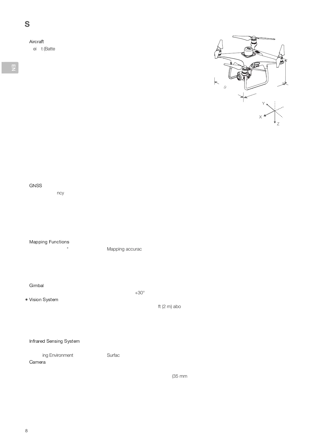
0THNL7VZP[PVU6ќZL[ The position of the camera center is relative to the phase center of the onboard D-RTK
antenna under the aircraft body’s axis: (36, 0, and 192 mm) already applied to the image
coordinates in Exif data. The positive x, y, and z axes of the aircraft body point to the
forward, rightward, and downward of the aircraft, respectively.
ҋ
Single-Frequency High-Sensitivity
GNSS
.7:)LP+V\.HSPSLV(ZPH".7:.365(::.HSPSLVV[OLYYLNPVUZ
Multi-Frequency Multi-System High-
Precision RTK GNSS
Frequency Used
.7:!33".365(::!33")LP+V\!))".HSPSLV!,,
First-Fixed Time: < 50 s
7VZP[PVUPUN(JJ\YHJ`!=LY[PJHSJTWWT94:"/VYPaVU[HSJTWWT94:
1 ppm indicates error with a 1 mm increase over 1 km of movement.
Velocity Accuracy: 0.03 m/s
ҋ
Mapping Accuracy** Mapping accuracy meets the requirements of the ASPRS Accuracy Standards for Digital
Orthophotos Class III.
Ground Sample Distance (GSD) (H/36.5) cm/pixel, H indicates the aircraft altitude relative to the shooting scene (unit: m)
(JX\PZP[PVU,ѝJPLUJ` Max operating area of approx. 1 km
2
MVYHZPUNSLÅPNO[H[HUHS[P[\KLVMTPL.:+PZ
approx. 5 cm/pixel, meeting the requirements of the ASPRS Accuracy Standards for Digital
Orthophotos Class III).
ҋ
Controllable Range Pitch: -90° to +30°
ҋ
Velocity Range TWORWOH[M[THIV]LNYV\UK^P[OHKLX\H[LSPNO[PUN
Altitude Range 0 - 33 ft (0 - 10 m)
Operating Range 0 - 33 ft (0 - 10 m)
Obstacle Sensory Range 2 - 98 ft (0.7 - 30 m)
Operating Environment Surfaces with clear patterns and adequate lighting (> 15 lux)
ҋ
Obstacle Sensory Range 0.6 - 23 ft (0.2 - 7 m)
Operating Environment :\YMHJL^P[OKPќ\ZLYLÅLJ[PVUTH[LYPHSHUKYLÅLJ[P]P[`%Z\JOHZ^HSS[YLLZO\THUZL[J
ҋ
Sensor »»*46:",ќLJ[P]LWP_LSZ!4
Lens FOV (Field of View) 84°, 8.8 mm (35 mm format equivalent: 24 mm), f/2.8 - f/11, auto focus
H[T
ISO Range Video: 100 - 3200 (Auto)
,
4HU\HS"7OV[V!(\[V
,
100 - 12800 (Manual)
* supported later
** The actual accuracy depends on surrounding lighting and patterns, aircraft altitude, mapping software used, and other factors when
shooting.
 Loading...