Do you have a question about the Garmin dezlCAM and is the answer not in the manual?
Instructions for inserting a memory card into the dash camera slot for video recording.
Guidance on attaching the device to the windshield and connecting it to power.
Steps to acquire satellite signals for navigation functionality.
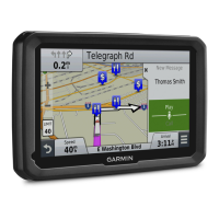
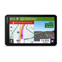
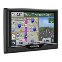
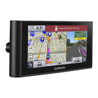
Explanation of icons displayed on the status bar for device features and status.
Procedure for aligning the dash camera for optimal recording perspective.
Details on legal restrictions and continuous video recording by the dash camera.
How to manually save video footage or how it's saved automatically upon events.
Instructions for capturing still photographs with the device.
Guide to creating a profile for different vehicle types and characteristics.
Steps to select and activate a previously created vehicle profile for navigation.
How to update trailer details within an existing vehicle profile.
Instructions for modifying, renaming, or deleting existing vehicle profiles.
Overview of how routes are calculated based on user preferences and vehicle data.
Step-by-step instructions to initiate navigation to a specific destination.
Method for manually adjusting the route's course to include specific roads or areas.
How to create a temporary detour around specific roads or distances.
How to select route calculation preferences like faster time or less fuel.
Guide to creating and saving multi-stop trips with scheduling information.
Steps to start navigation for a previously saved trip itinerary.
How to automatically reorder trip stops for a more efficient route.
Using the search bar to find addresses, businesses, or cities by entering terms.
How to find points of interest based on categories like restaurants or hotels.
How to route to a point of interest inside a larger venue like a mall or airport.
Accessing a list of the last 50 destinations found by the device.
How to select and enable various tools that appear on the map interface.
How to view upcoming businesses and services along your route.
How to view trip data, logs, and statistics directly on the map.
How to control which data elements like POIs and road conditions appear on the map.
How to set the map view orientation, such as 2D Track Up or 3D.
Methods for receiving traffic information via receiver or Smartphone Link.
Information about safety camera locations and speed limits.
How to set a custom phrase to activate voice command features.
How to initiate voice command by speaking the designated wakeup phrase.
How to operate the device using recorded voice commands for hands-free control.
Archiving data for International Fuel Tax Agreement, including fuel purchases.
Recording driver working hours to comply with safety regulations.
How to record vehicle maintenance and service records.
Steps to activate Bluetooth on the device for wireless connectivity.
Steps to connect a mobile phone to the device via Bluetooth for calls.
How to answer or ignore incoming phone calls through the device.
Instructions for downloading the Smartphone Link application onto your phone.
Steps to establish a connection between the device and the Smartphone Link app.
Steps to subscribe to available live data services like traffic and weather.
How to adjust fuel economy settings for more accurate reports.
How to view scores for acceleration, braking, and speed for fuel efficiency.
Advice and best practices for improving fuel economy and driving habits.
How to check the detailed weather forecast for a selected day.
How to access animated radar maps of current weather conditions.
How to view weather alerts that may appear on the map.
How to adjust map appearance, detail, theme, and vehicle icon settings.
How to configure route calculation, avoidances, and environmental zone preferences.
How to configure dash camera recording options like incident detection and audio.
How to manage Bluetooth connectivity, search for devices, and disable it.
How to adjust display color mode, brightness, and timeout.
How to enable and configure traffic data features, providers, and alerts.
How to set units of measure, time format, and position format.
How to select voice and text languages, and keyboard layout.
How to view device information, software version, and license agreements.
Information on getting help and updating the device software and maps.
Instructions for installing and setting up Garmin Express software for device management.
Steps to update device maps and software using Garmin Express.
General information about the device, including cleaning and avoiding theft.
How to revert device settings to factory default values.
| Auto | Yes |
|---|---|
| Marine (chartplotters, sounders) | No |
| Live service | - |
| Number of waypoints | 1000 |
| Map coverage | All Europe, USA |
| Display diagonal | 6.1 \ |
| Display resolution | 800 x 480 pixels |
| Display size (HxV) (imperial) | 2.8 x 5.4 \ |
| Compatible memory cards | MicroSD (TransFlash) |
| Form factor | Handheld/Fixed |
| Product color | Black |
| Power source type | Battery |
| Depth | 15 mm |
|---|---|
| Width | 183 mm |
| Height | 94 mm |
| Weight | 319.2 g |