Do you have a question about the Garmin DEZLCAM 785 and is the answer not in the manual?
Details how to install and power the device in the vehicle.
Managing different vehicle profiles for customized routing and settings.
Proper alignment of the dash camera for optimal recording.
Buttons and functions for operating the dash cam.
How video recording works, including continuous overwriting.
Method to save specific recorded video clips.
Accessing, viewing, and managing recorded dash cam footage.
Guide to replacing the memory card for increased storage.
Systems that provide alerts for driving safety.
Information on speed and red light camera alerts.
Overview of ADAS features using the dash camera.
System that warns of potential forward collisions.
Factors affecting the performance of the FCWS.
System that warns of unintentional lane departures.
Adjusting camera position settings for optimal performance.
Factors affecting the accuracy of lane departure warnings.
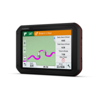
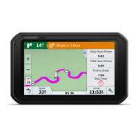
Information on how routes are calculated and used.
Step-by-step guide to initiating navigation to a destination.
How to start navigation by selecting a location directly on the map.
Instructions for navigating to your pre-set home location.
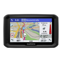
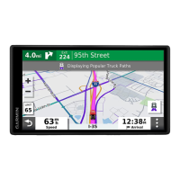
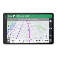
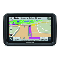
Understanding the map display during active navigation.
Visual guidance for proper lane selection during turns.
Information provided as you approach your destination.
Finding available parking spots at your destination.
Modifying the current navigation route.
Inserting new destinations into an active route.
Manually adjusting the route's path.
Creating a temporary rerouting around a specific road or distance.
Setting preferences to avoid specific road features or areas.
Routing around areas with significant traffic congestion.
Preventing routes from including toll roads or bridges.
Locating truck-specific services like stops and weigh stations.
Accessing the TruckDown directory for truck repair and tire sales.
Searching for locations by entering keywords in a search bar.
How to search for a specific street address.
Searching for locations organized by categories like fuel or lodging.
Features for finding parking spots, including live data.
Specifically locating parking for trucks.
Searching for parking based on your current position.
Displaying details about your current geographical position.
Locating essential services like hospitals and gas stations.
Storing frequently visited locations for quick access.
Quick access tools for map interaction and information.
Displays upcoming points of interest and road information.
Icons indicating hazards, road conditions, and weigh stations.
Alerts for vehicle restrictions like height or weight.
Alerts for road hazards like steep hills or curves.
General alerts for road conditions and warnings.
Information on traffic conditions and delays.
Personalizing the appearance and data displayed on the map.
Connecting your smartphone via Bluetooth for device integration.
Transferring locations from smartphone to the navigation device.
Receiving smartphone notifications on the device.
Using the device for making and receiving phone calls.
Information and features related to real-time traffic data.
How the device receives traffic data via Smartphone Link.
Displaying traffic flow and delays on the map.
Finding specific traffic events and delays.
Viewing live images from traffic cameras.
Features related to vehicle operation and driver compliance.
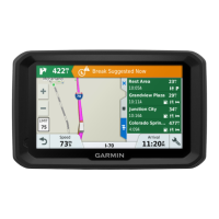
Features to help manage driving breaks and hours.
How to use suggested break locations.
Manually adjusting total drive hours to match service records.
Setting the daily driving limit according to regulations.
Features for sharing trip information with dispatchers or contacts.
Recording fuel purchase and mileage for IFTA documentation.
Overview of the Electronic Logging Device (ELD) system.
Initial setup and configuration of the eLog adapter.
Best practices for daily use of the Garmin eLog system.
Updating your driver status (e.g., driving, off duty).
Finalizing and certifying your daily driving logs.
Creating and saving official RODS reports.
Preparing for and providing data during roadside inspections.
Providing inspection data via a USB drive.
Sharing inspection data wirelessly.
Overview of system alerts for diagnostics and issues.
Explanations of different diagnostic event types.
Explanations of different malfunction types.
Managing app settings and user profiles as an administrator.
Resetting the eLog app to factory defaults.
Using voice commands to operate the device.
Creating, saving, and navigating multi-destination trips.
Configuring driver alerts and safety features.
Managing traffic data reception and preferences.
Configuring dash camera recording and features.
Enabling and adjusting sensitivity for FCWS.
Enabling alerts for unintentional lane departures.
How to update device software and maps wirelessly.
Solutions for mounting issues with the suction cup.
Troubleshooting tips for a loose device mount.
Steps to resolve issues with GPS signal acquisition.
Solutions for vehicle charging problems.
Troubleshooting Bluetooth and Smartphone Link connectivity.
| Widescreen | - |
|---|---|
| Display diagonal | 6.95 \ |
| Display resolution | 1024 x 600 pixels |
| Display size (HxV) | 152 x 89 mm |
| Display size (HxV) (imperial) | 6 x 3.5 \ |
| Power source type | Battery |
| Battery life (max) | 2 h |
| Lifetime map updates | Roads change, but with Lifetime Map Updates your map will always be up to date. Start fresh every few months by downloading a new edition of the industry's most accurate map. New editions are issued four times per year. |
| Supported radio bands | Not supported |
| Storage media type | Memory card |
| Compatible memory cards | MicroSD (TransFlash) |
| Maximum memory card size | 64 GB |
| Included memory card size | 8 GB |
| Hands-free calling | Keep your hands on wheel with Bluetooth™ Hands-free calling. After pairing your compatible Bluetooth mobile phone to your TomTom GPS, you’ll be able to see incoming call information, make and answer calls, and talk hands-free through your device. You’ll e |
| Traffic Message Channel (TMC) | No |
| Headphone outputs | 1 |
| Headphone connectivity | 3.5 mm |
| Cables included | USB |
| Operating temperature (T-T) | -10 - 55 °C |
| Form factor | Fixed |
| Product color | Black |
| Depth | 122 mm |
|---|---|
| Width | 199 mm |
| Height | 24 mm |
| Weight | 437 g |