Do you have a question about the Garmin DRIVE 52 and is the answer not in the manual?
Provides an overview of the device's hardware components and ports.
Instructions for mounting the device and connecting it to power in a vehicle.
Steps to power the device on, enter power saving mode, or turn it off completely.
Explains how the device acquires satellite signals for location tracking.
Introduces how to find and navigate to a destination.
Details the icons displayed on the status bar for device information.
Explains how to use the device's on-screen navigation buttons.
How to turn audible alerts on or off for driver assistance features.
Information on approaching red light and speed cameras and database updates.
Step-by-step guide to searching for locations by category, name, or address.
Instructions for searching for a specific street address.
How search results are displayed and how to view them.
Viewing search results directly on the device's map interface.
How to modify the area used for location searches.
Understanding and finding points of interest like restaurants or fuel stations.
How to search for points of interest by browsing categories.
Instructions for finding and navigating to national parks and locations within them.
How to find and learn about historically significant locations.
Using Foursquare points of interest for location-based social networking.
Finding and searching TripAdvisor points of interest and reviews.
Routing to specific points of interest inside larger venues like shopping centers.
Overview of search tools for specific location types.
How to search for junctions between roads.
How to find a location using latitude and longitude coordinates.
Information on finding parking based on availability, type, price, or payment.
Steps to find nearby parking spots based on current location.
How to find parking near a specific destination.
Explains parking data colour-coding and symbols.
How to view the history of recently found locations.
Steps to clear the location history.
Accessing location details via the 'Where Am I?' page.
Locating nearby emergency services and fuel stations.
Providing directions to your current location for others.
How to manage shortcuts in the Where To? menu.
General section on saving locations.
How to save a searched location with a custom name.
How to save the device's current position.
Modifying saved favourite locations, including name and category.
How to add custom categories to organize saved locations.
Steps to remove saved favorite locations from the device.
Steps to begin navigating a route to a chosen destination.
How to initiate a route by selecting a location directly on the map.
How to set and navigate to your home location.
Steps to change or update the stored home location.
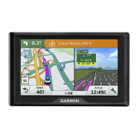
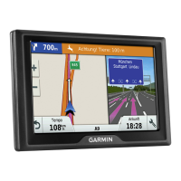
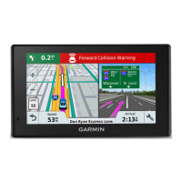
Understanding the map display during navigation, including turn instructions.
Visual guidance for selecting the correct lane for turns and exits.
How to view upcoming turns, lane changes, and route directions.
Displaying the complete route on the map for an overview.
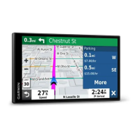
Information provided as you approach your destination, including parking.
How the device helps find parking spots near the destination.
How to locate your vehicle's last parked position.
Options for modifying the current navigation route.
How to insert additional destinations into an active route.
How to bypass the next stop in a multi-destination route.
Manually altering the route's path by adding shaping points.
How to detour around specific roads or for a set distance.
Using Off Road mode for navigation without following roadways.
Setting preferences for how routes are calculated (e.g., fastest time, shortest distance).
How to manually end the current navigation route.
Utilizing the myTrends feature for predicted routes based on history.
Options to avoid traffic, tolls, and specific road features.
How to enable automatic avoidance of traffic delays on routes.
Setting preferences to avoid toll roads, bridges, or congestion areas.
Avoiding roads that require specific toll stickers by country.
Selecting specific road features to avoid during route calculation.
Avoiding areas with environmental or emissions restrictions.
Defining specific areas or roads to avoid on routes.
Temporarily turning off a custom avoidance without deleting it.
Removing custom avoidances from the device settings.
Accessing quick information and device functions while viewing the map.
Displaying upcoming locations like restaurants or fuel stations along the route.
How the Up Ahead tool shows next locations and categories.
Changing the location categories displayed in the Up Ahead tool.
Information about upcoming towns, exits, and services on highways.
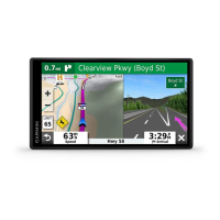
Viewing trip data such as speed, distance, and time.
Displaying trip data fields directly on the map interface.
Accessing the device's record of traveled paths.
Steps to reset trip data fields and the trip computer.
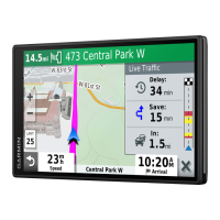
How to view traffic incidents and delays along the route.
Displaying colour-coded traffic flow and delays on nearby roads.
Finding specific traffic incidents on the map.
Options for adjusting map appearance and data display.
Selecting which data layers (e.g., POIs, road conditions) appear on the map.
Selecting the type of data displayed in map data fields.
Adjusting the map view between 2-D (Track Up/North Up) and 3-D.
How the device receives traffic data using a built-in receiver.
Information on accessing help and support from Garmin.
Importance of keeping maps and software updated for optimal performance.
Step-by-step guide to updating maps and software using the Garmin Express application.
Guidelines for maintaining the device, including cleaning and avoiding damage.
Tips to prevent device theft, such as removing it from view.
How to restart the device if it becomes unresponsive.
Instructions for detaching the device, mount, and suction cup.
How to replace the fuse in the vehicle power adapter cable.
Solutions for issues with the suction cup not adhering to the windscreen.
Steps to resolve problems with the device not finding GPS signals.
Troubleshooting steps for when the device fails to charge in the vehicle.
Tips to improve battery life and resolve charging issues.
Instructions for installing a memory card for additional storage.
Information on storing and managing files on the device and memory card.
How to connect the device to a computer via USB for data transfer.
Steps to copy files from a computer to the device.
How to safely disconnect the device from a computer to prevent data loss.
How to check the device's GPS signal strength and status.
Information on buying more maps for the device.
Information on where to buy accessories for the device.
Setting preferences for avoiding toll roads and toll stickers.
Disables functions requiring operator attention for safety.
Simulates GPS signals for planning routes indoors or without signal.
Setting route calculation methods (Faster Time, Shorter Distance, Off Road).
How to use the GPS simulator to plan routes from a simulated location.
Configuring driver alerts, speeding alerts, and break planning.
Customizing alerts for approaching proximity points like cameras.
Managing paired Garmin backup cameras and their settings.
Adjusting colour mode, brightness, and display timeout.
Configuring traffic features, providers, and alerts.
Setting units of measurement, time format, and co-ordinate format.
How to set the device's time automatically or manually.
Changing voice and text languages, and keyboard layout.
Displays software version, unit ID, regulatory information, and EULAS.
Options for clearing travel history, resetting settings, or deleting all user data.
Viewing regulatory and compliance information and specifications.
Details operating temperature, charging range, and battery type.
Methods for charging the device's battery using vehicle or AC power.
| Auto | Yes |
|---|---|
| Marine (chartplotters, sounders) | No |
| Address input | City, House number, Street |
| Languages support | - |
| Map storage | Internal storage |
| Map coverage | Canada, USA |
| Lifetime map updates | Roads change, but with Lifetime Map Updates your map will always be up to date. Start fresh every few months by downloading a new edition of the industry's most accurate map. New editions are issued four times per year. |
| Display diagonal | 5 \ |
| Display resolution | 480 x 272 pixels |
| Placement supported | Horizontal |
| Display size (HxV) (imperial) | 2.5 x 4.4 \ |
| Storage media type | Memory card |
| Compatible memory cards | MicroSD (TransFlash) |
| Internal storage capacity | 2 GB |
| Supported radio bands | Not supported |
| Form factor | Fixed |
| Product color | Black |
| Mini-USB 2.0 ports quantity | 1 |
| Battery type | Built-in |
| Power source type | USB |
| Operating temperature (T-T) | -20 - 55 °C |
| Depth | 20 mm |
|---|---|
| Width | 140 mm |
| Height | 84 mm |
| Weight | 170.8 g |