Do you have a question about the Garmin DRIVESMART 76 and is the answer not in the manual?
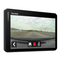
Provides an overview of the device's physical components and their functions.
Details the components and functionality of the vehicle power adapter and its ports.
Provides guidelines and warnings for safely mounting the device in a vehicle.
Step-by-step instructions for mounting and powering the device in your vehicle.
Instructions on how to connect the device to a smartphone using the Garmin Drive app.
Explains how to connect the device to a vehicle stereo via Bluetooth for audio output.
Describes different Bluetooth modes for audio transmission (Media vs. Phone Call).
Details how to connect the device to a vehicle stereo using a 3.5mm auxiliary audio cable.
Instructions on how to turn the device on, off, or put it into power saving mode.
Explains the process and factors affecting GPS signal acquisition for navigation.
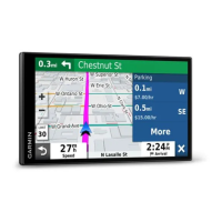
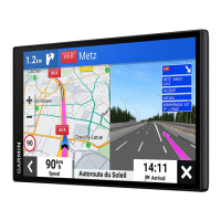
Details status bar icons and how to navigate using on-screen buttons.
Guides on how to adjust device volume and screen brightness levels.
Guidance on speaking clearly and reducing background noise for voice commands.
How to initiate voice commands for navigation features like searching and routing.
How to start routes using voice commands for saved locations or addresses.
Overview of Alexa integration for music, weather, skills, and media playback.
Instructions on how to mute or unmute the device's microphones for voice features.
How to enable or disable various driver alerts like speed limit warnings.
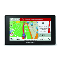
Information on device alerts for red light and speed cameras.
Steps to search for locations using the search bar, addresses, or categories.
How to interpret search results, find parking, and view nearby locations.
Instructions for saving, editing, categorizing, and deleting locations.
How to start routes, choose alternate routes, and shape the route course.
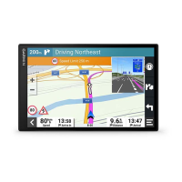
Explanation of elements on the map during navigation and active lane guidance.
Device features for approaching destinations and finding parking spots.
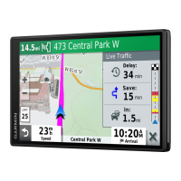
How to configure the device to avoid traffic delays, tolls, and environmental zones.
Overview of map tools like Up Ahead and Cities Ahead for route information.
How to view trip data, reset trip information, and check upcoming traffic.
How to check weather forecasts, radar, and view weather alerts.
How to use the route planner to create, edit, and save routes.
Instructions for pairing, viewing, and aligning guidance lines for wireless cameras.
Settings for map display, vehicle icon, map detail, and theme.
Settings for route calculation modes, avoidances, and environmental zones.
Settings for managing Wi-Fi networks, paired Bluetooth devices, and smartphone services.
Settings for display orientation, color mode, brightness, and time configuration.
How to update maps and software using Wi-Fi or Garmin Express.
General care instructions, cleaning, and troubleshooting common device issues.
Instructions for installing memory cards and connecting the device to a computer.
| Auto | Yes |
|---|---|
| Marine (chartplotters, sounders) | No |
| Languages support | - |
| Form factor | Fixed |
| Product color | Black |
| Lifetime map updates | Roads change, but with Lifetime Map Updates your map will always be up to date. Start fresh every few months by downloading a new edition of the industry's most accurate map. New editions are issued four times per year. |
| Power source type | Battery |
| Battery life (max) | 1 h |
| Display diagonal | 7 \ |
| Touch technology | Multi-touch |
| Display resolution | 1024 x 600 pixels |
| Display size (HxV) | 152 x 89 mm |
| Display size (HxV) (imperial) | 6 x 3.5 \ |
| Storage media type | Memory card |
| Compatible memory cards | MicroSD (TransFlash) |
| Internal storage capacity | 32 GB |
| Depth | 19 mm |
|---|---|
| Width | 173 mm |
| Height | 99 mm |
| Weight | 239.6 g |