Do you have a question about the Garmin G1000:Beechcraft Baron 58/G58 and is the answer not in the manual?
Emphasizes that the G1000 Terrain Proximity feature is not a primary reference for terrain avoidance.
Advises pilots to always refer to current aeronautical charts for minimum clearance altitudes.
Clarifies GPS altitude is geometric and may differ from pressure altimeter readings; warns against using it for vertical navigation.
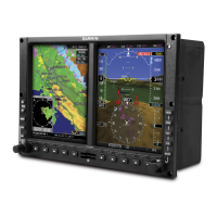
Provides an overview of the G1000 Integrated Flight Deck system and its Line Replaceable Units (LRUs).
Details the flight instruments and supplemental data displayed on the PFDs.
Explains the G1000 alerting system, including warnings, cautions, advisories, and annunciations.
Details the Engine Indication System (EIS) display, including gauges and digital readouts.
Covers COM transceiver selection, activation, manual tuning, and auto-tuning.
Details NAV radio selection, manual tuning, auto-tuning, and CDI settings.
Introduces the G1000 flight management system and its displays.
Explains how to use map displays, including orientation, range, panning, and declutter.
Covers creating, selecting, and managing waypoints, including airports, NAVAIDs, and user waypoints.
Explains how to use the Direct-to feature for point-to-point navigation and VNV.
Covers creating, storing, editing, and managing flight plans, including airways and procedures.
Details Vertical Navigation (VNV) features for enroute, terminal, and approach phases.
Explains how to load and manage departures, arrivals, and approaches.
Provides an example of navigating a flight plan with WAAS GPS and vertical guidance.
Covers XM Satellite Weather, Weather Radar, and Stormscope features.
Explains the GWX 68 Weather Radar system, its features, and principles of operation.
Details TAWS features, alerts, colors, symbols, and data display.
Provides an overview of the GFC 700 AFCS, its functions, and LRUs.
Explains flight director modes, command bars, and switching between flight directors.
Details vertical modes like Pitch Hold, Altitude Hold, Vertical Speed, and Flight Level Change.
Relates lateral modes to controls and annunciations, including Roll Hold and Heading Select.
Defines the three alert levels: WARNING, CAUTION, and ANNUNCIATION/MESSAGE ADVISORY.