Do you have a question about the Garmin STRIKER PLUS 4 and is the answer not in the manual?
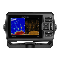
Explains the function of each physical button on the device.
Overview of the main screen and its features.
Information on acquiring GPS signals and indicators.
How to add, remove, or rearrange items on the Home screen.
Explains combining multiple functions on one screen.
Step-by-step guide to creating custom combination pages for specific STRIKER Plus models.
How to modify existing combination pages' layout and content.
Adjusting screen brightness for better visibility.
Changing the screen's color display mode.
Configuring sound alerts for selections and alarms.
Explains user roles within the ActiveCaptain app.
Initial steps to connect and use the ActiveCaptain app.
How to display mobile notifications on the device.
Guide to updating device software via the ActiveCaptain app.
Describes the full-screen traditional sonar display.
Explains the high-frequency ClearVü sonar view.
Details the SideVü sonar view for lateral scanning.
Viewing two frequencies simultaneously.
Describes the circular depth scale flasher display.
Combines a full view with a magnified sonar portion.
How to set the correct transducer type for sonar functionality.
Explains how frequency affects sonar performance and targeting.
Indicates which frequencies appear on the sonar screen.
How to mark a waypoint directly from a sonar screen.
Instructions on how to pause the sonar display.
Manually or automatically adjusting the sonar zoom.
Keeping the sonar screen fixed to the water bottom.
Adjusting sonar receiver sensitivity for detail or clutter reduction.
Using automatic gain settings for optimal sonar display.
Manually adjusting sonar gain for specific conditions.
How to adjust the depth scale displayed on the sonar screen.
Displaying and adjusting a horizontal depth line on the sonar.
Adjusting how fast the sonar image scrolls across the screen.
Setting the maximum depth for auto-range bottom search.
Customizing sonar display settings like color and symbols.
Activating the vertical flasher for detailed sonar data.
Customizing how fish symbols and data are displayed.
Reducing interference and surface noise in sonar display.
Customizing data displayed on the sonar screen.
Settings for customizing Garmin Quickdraw Contours display.
Setting color ranges for different water depths on maps.
How to find saved destinations by entering their names.
Marking a new waypoint location directly on the map.
Instructions for setting a course to a saved waypoint.
Creating and following routes on the device's map.
How to end an active navigation session.
General information about recording and storing waypoints.
Quickly saving your current position as a waypoint.
Manually creating a waypoint at a specified location.
Quickly marking and navigating back to an MOB location.
How to measure distances between points on the map.
Accessing and viewing all saved waypoints.
Modifying names, symbols, or other data of saved waypoints.
Removing individual waypoints or MOB markers.
Clearing all stored waypoints from the device.
Procedure for creating and saving a route with waypoints.
Accessing and viewing all saved routes.
Modifying saved routes, including names and turns.
Selecting and following a previously saved route.
Navigating alongside a saved route at a set offset.
Removing individual saved routes.
Clearing all saved routes from the device memory.
Displaying recorded tracks on the chart.
Erasing the currently recorded active track data.
Storing the currently recorded active track.
Accessing and viewing all saved track logs.
Modifying saved tracks, such as changing color or name.
Converting a saved track into a navigable route.
Selecting and following a previously recorded track.
Removing individual saved tracks.
Clearing all saved track logs from the device.
Following the currently active track.
Changing the color used to display the active track.
Configuring how track log memory is managed.
Setting the frequency for recording track points.
Accessing general system settings like display and beeper.
Viewing device and software details.
Detailed steps to input keel offset values.
Detailed steps to input temperature offset values.
Setting alarms for arrival, anchor drag, and off course.
Setting alarms for clock, device voltage, and GPS accuracy.
Setting alarms for sonar events like fish detection.
Setting units for measurement, variance, and position.
Setting preferences for route display and turn transitions.
How to connect devices to share data.
Removing user data like waypoints, routes, and tracks.
Instructions for registering the device.
Technical specifications of the device.
Solutions for power issues.
Step-by-step guide to replacing the power cable fuse.
Troubleshooting steps for GPS signal acquisition problems.
Solutions for issues with the sonar functionality.
Resolving issues with waypoint accuracy.
Troubleshooting steps for incorrect time display.
| Display Size | 4.3 inches |
|---|---|
| Display Resolution | 480 x 272 pixels |
| Maximum Depth Saltwater | 750 ft |
| GPS | Yes |
| Waypoints | 5, 000 |
| Routes | 100 |
| Water Rating | IPX7 |
| Transmit Power | 200 W (RMS) |
| Transducer | GT20-TM |
| Maximum Depth Freshwater | 1600 ft |
| Frequencies Supported | 77/200 kHz |
| Track Log | 50 saved tracks |
| Operating Temperature | From -20°C to 70°C |
| Dimensions | 9.8 x 17.4 x 4.5 cm |
| Weight | 0.3 kg |