Do you have a question about the Garmin ECHOMAP UHD and is the answer not in the manual?
Details the front view of the ECHOMAP UHD 60 device, identifying key components.
Explains the function of each button on the ECHOMAP UHD 60 device for various operations.
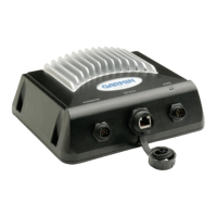
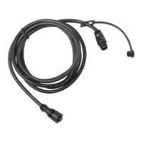
Illustrates and describes the ports and connectors on the rear of the ECHOMAP UHD 60.
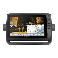
Details the front view of the ECHOMAP UHD 70/90 devices, identifying key components.
Guides on how to assign custom shortcuts to device keys for quick access to screens.
Provides instructions on how to access owner's manuals and supplemental information online.
Explains how to insert and use microSD memory cards for data storage and map expansion.
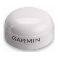
Allows selection of the preferred GPS data source when multiple sources are available.
Guides on how to add, remove, and rearrange items on the Home screen interface.
Explains how to create and customize combination pages with multiple data fields.
Details how to customize the data displayed in screen overlays for various views.
Configures chartplotter settings based on the type of vessel for optimized features.
Allows adjustment of the screen backlight level for optimal viewing.
Describes the different roles (Owner, Guest) and their permissions within the app.
Provides steps to connect a mobile device and set up the ActiveCaptain app.
Guides on how to receive phone notifications like calls and texts on the chartplotter.
Explains how to download and install software updates using the ActiveCaptain app.
Compares the Navigation and Fishing chart views and their optimal uses.
Instructions on how to adjust the zoom level of the chart display.
Explains how to move the chart view using the device's keys.
Provides a legend for common symbols used on detailed charts.
Guides on how to mark a specific location on the chart as a waypoint.
Instructions on how to set a course and navigate to a selected map point.
Explains how to overlay high-resolution satellite images onto the navigation chart.
Explains the meaning of various symbols used to represent AIS targets on the chart.
Guides on how to select and activate an AIS target for detailed tracking.
Explains how to configure a collision alarm based on proximity to other vessels.
Describes AIS Aids to Navigation (ATONs) and their display on charts.
Explains how to turn chart layers on/off and customize chart features.
Details specific settings for chart layers like satellite photos and tides.
Allows customization of chart layers related to the vessel's status and information.
Configuration options for displaying laylines in sailing mode.
Addresses common questions regarding basic navigation functions and operations.
Explains the meaning of different colors used for route and course lines on the chart.
Provides methods for selecting destinations using charts and lists.
Information on creating, saving, editing, and managing waypoints.
Details on creating, saving, editing, and navigating routes.
Explains how to use the Auto Guidance feature for route planning.
Covers recording, saving, viewing, and managing boat tracks.
Information on creating, editing, and managing navigational boundaries.
Details how the device supports sail racing with features like start line guidance.
Configuration options for displaying laylines on the navigation chart.
How to compensate depth readings based on transducer and keel position.
Explains how to use the autopilot to maintain a specific bearing relative to the wind.
Instructions on how to disable active sonar transmission.
Description of the full-screen traditional sonar view and its display.
Details the Garmin ClearVü scanning sonar technology and its image representation.
Explains the SideVü sonar view, showing what lies to the sides of the boat.
Overview of the different Panoptix sonar views available for real-time imaging.
Guides on how to select the correct transducer type for optimal sonar function.
Allows customization of the sonar screen's color scheme and display elements.
Information on setting up sonar-related alarms for situational awareness.
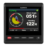
Provides an overview of the autopilot interface and its indicators.
Guides on selecting the preferred source for heading data for autopilot.
Explains how to enable the Shadow Drive feature for manual steering override.
Instructions on how to engage the autopilot system to maintain heading.
Details various preset steering patterns for fishing and maneuvers.
Information on wirelessly connecting and using the Reactor autopilot remote control.
Guides on wirelessly connecting the Force trolling motor to the chartplotter.
Explains how to add the trolling motor control bar to the chartplotter screens.
Details various settings for calibrating and configuring the trolling motor.
Explains DSC functionality when connected to a NMEA 0183 VHF radio.
Describes the log of recent DSC calls and contacts stored on the device.
Details how the chartplotter alerts users to incoming DSC distress calls.
Guides on how to edit details within a recorded DSC position report.
Explains how to set up and make individual routine calls via VHF radio.
How to view bearing, heading, and route information using the compass display.
Displays trip odometer, speed, time, and fuel consumption data.
How to view engine and fuel data when connected to NMEA 2000 sensors.
Allows setting an alarm for when the onboard fuel reaches a specified low level.
Instructions on how to view wind information from a connected wind sensor.
Guides on controlling the Power-Pole anchor system via the chartplotter.
How to enable and select an active Mercury Helm for engine control.
Information on using the Mercury Troll overlay to adjust trolling speed.
Details on setting and adjusting the cruise control function for Mercury engines.
Guides on creating and customizing digital switching pages for vessel controls.
How to view tide height and prediction data for tide stations.
Information on sunrise, sunset, moon phase, and sky view locations.
How to view historical or future tide, current, or celestial data.
Instructions on browsing, playing, and controlling music playback.
Information on VHF radio features like channel scanning and squelch adjustment.
Details on tuning AM/FM and SiriusXM radio stations, including presets.
Explains how to tune in and play Digital Audio Broadcasting (DAB) stations.
Information on accessing SiriusXM radio, including activation and channel guide.
Overview of system settings including display, beeper, and satellite positioning.
Settings related to vessel type, keel offset, and fuel capacity.
Configuration options for serial port, NMEA 0183, NMEA 2000, and wireless devices.
Guides on setting up and connecting to a Wi-Fi network.
Configuration of navigation and system alarms for safety and alerts.
Instructions on sharing user data like waypoints between compatible Garmin devices.
How to transfer user data from a memory card to the chartplotter.
How to save user data from the chartplotter to a memory card.
Guides on removing saved user data, waypoints, routes, and tracks.
Overview of ActiveCaptain and Garmin Express apps for device management.
Step-by-step guide to register your device using the Garmin Express application.
Instructions for downloading and updating charts via the Garmin Express app.
General information on when and how to update device software.
Provides instructions on how to safely clean the device's anti-reflective screen.
Common issues and their solutions, including GPS and power problems.
General specifications applicable to all ECHOMAP UHD models.
Detailed specifications specific to the 6-inch ECHOMAP UHD models.
Detailed specifications specific to the 7-inch ECHOMAP UHD models.
Detailed specifications specific to the 9-inch ECHOMAP UHD models.
Specifications related to the sonar capabilities and frequencies.
| Water Rating | IPX7 |
|---|---|
| Routes | 100 |
| Sonar | Yes (CHIRP, ClearVü, SideVü) |
| GPS | Yes |
| Preloaded Maps | Yes |
| Network Support | Yes, Garmin Marine Network |
| Wi-Fi | Yes |
| Mounting Options | Flush mount |
| Antenna | Internal |
| Transmitter Power | 500W (RMS), 4000W (peak to peak) |
| Sonar Frequencies Supported | ClearVü/SideVü: 260/455/800 kHz |
| Maximum Depth | 2, 300 ft (freshwater) |
| Wireless Connectivity | Wi-Fi |