Converting a Route to a Boundary
1 Select Nav Info > Routes.
2 Select a route.
3 Select Review > Edit Route > Save as Boundary.
Converting a Track to a Boundary
1 Select Nav Info > Tracks > Saved Tracks.
2 Select a track.
3 Select Review > Edit Track > Save as Boundary.
Editing a Boundary
1 Select Nav Info > Boundaries.
2 Select a boundary.
3 Select Review.
4 Select an option:
• To edit the appearance of the boundary on the chart, select Display Options.
• To change the boundary lines or name, select Edit Boundary.
• To edit the boundary alarm, select Alarm.
Setting a Boundary Alarm
Boundary alarms alert you when you are within a specified distance of a set boundary. This can be helpful when
attempting to avoid certain areas or when you should be very alert in certain areas, such as shipping lanes.
1 Select Nav Info > Boundaries.
2 Select a boundary.
3 Select Review > Alarm.
4 Select an option:
• To set an alarm for when your boat is a specified distance from the boundary, select Warning Distance,
enter a distance, and select Done.
• To set an alarm for when you enter or exit an area boundary or a circle boundary, select Area to show
Entering or Exiting.
Deleting a Boundary
1 Select Nav Info > Boundaries.
2 Select a boundary.
3 Select Review > Edit Boundary > Delete.
Deleting All Saved Waypoints, Tracks, Routes, and Boundaries
Select Nav Info > Manage Data > Clear User Data > All > OK.
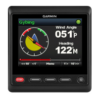
Sailing Features
Setting the Vessel Type for Sailing Features
You must select a sailing vessel type to use the sailing features.
1 Select Settings > My Vessel > Vessel Type.
2 Select Sailboat or Sailing Catamaran.
42 Sailing Features