Do you have a question about the Garmin Tread SXS Edition and is the answer not in the manual?
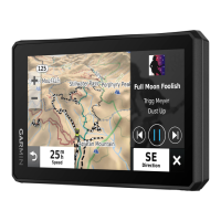
Display Size | 5.5 inches |
---|---|
Touchscreen | Yes |
Water Rating | IP67 |
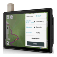
Preloaded Maps | Yes |
Internal Storage | 16 GB |
Wi-Fi | Yes |
Bluetooth | Yes |
GPS | Yes |
GLONASS | Yes |
Galileo | Yes |
ANT+ | Yes |
Barometric Altimeter | Yes |
Compass | Yes |
External Memory Storage | microSD card |
Instructions for powering the device on, off, or into power-saving mode.
Steps to ensure the device successfully obtains satellite signals for location.
Configure device settings based on specific vehicle characteristics.
Instructions for mounting the device in specific vehicle types.
Detailed steps for attaching the device mount to a roll bar.
Guide to properly positioning and attaching the external antenna.
Steps for attaching the fist microphone mount to the dashboard.
Definition and general information about creating and navigating routes.
Creating a new group ride session with custom channel and name.
Connecting to a nearby group ride created by another user.
Sending and receiving text messages via the Iridium satellite network.
Using pre-defined messages for quick communication.
Composing and sending custom text messages through inReach.
Recording and transmitting track points via the Iridium satellite network.
Initiating the tracking function to record your path.
Using the SOS button to contact emergency response services.
Steps to activate an SOS rescue in an emergency situation.
Procedure to cancel an active SOS rescue request.
Displaying real-time traffic conditions and incidents on the map.
Adjusting the visual appearance and data displayed on the map.
Ensuring data transmission from dog's handheld device.
Viewing dog locations and tracking logs on the device map.
Procedure for downloading BirdsEye imagery to the device.
Creating, saving, and managing custom routes for navigation.
Step-by-step guide to creating a new route with multiple destinations.
Customizing route calculation preferences like shaping points or modes.
Starting navigation for a previously saved route.
Retracing your recent path back to a previous location.
Using TracBack to view and navigate your recorded track segment.
Accessing current weather conditions and future forecasts.
Generating a route based on distance, duration, or destination.
Turning on or off connected accessories using the PowerSwitch app.
Personalizing button labels, icons, colors, and functions.
Automating accessory operations based on defined triggers and actions.
Creating new routines with specific triggers and associated actions.
Connecting the Tread device to a smartphone via Bluetooth and the Tread app.
Connecting other Bluetooth devices like headsets or phones.
Receiving and viewing notifications from your smartphone on the device.
Viewing pop-up notifications from your smartphone on the device.
Making and receiving phone calls through the device via Bluetooth.
Initiating phone calls using the device's dial pad or contacts.
Initiating navigation to a destination using search or map selection.
Beginning navigation by selecting a destination directly on the map.
Displaying navigation instructions, route highlights, and traffic information.
Inserting new destinations into an active route at various points.
Configuring preferences to avoid traffic, tolls, and specific road features.
Connecting to a smartphone to access subscription-free traffic data.
Interpreting color-coded traffic flow and delay status on the map.
Searching for locations by entering keywords, addresses, or town names.
Viewing and selecting locations from search query results.
Browsing and searching for points of interest organized by category.
Utilizing on-screen prompts to search for specific location types.
Searching for locations by entering street number and address.
Locating nearby hospitals, police stations, and fuel stations.
Storing important locations for future reference and navigation.
Manually saving a searched or found location.
Controlling audible alerts for various driver assistance features.
Configuring route calculation, avoidances, and voice prompts.
Adjusting map display, vehicle icons, and map layers.
Activating Bluetooth for connecting to smartphones and headsets.
Managing driver alerts, proximity alerts, and break planning features.
Configuring traffic feature availability, providers, and alerts.
Keeping device maps and software current for optimal performance.
Using a Wi-Fi network to download and install device updates.
Using the Garmin Express application on a computer for updates.
Procedure for rebooting the device if it becomes unresponsive.
Solutions for issues with the device not acquiring GPS satellite signals.
Troubleshooting steps for poor battery life and charging issues.
Resolving Bluetooth connection problems between the device and a smartphone.
Troubleshooting why the device isn't recognized as a storage drive by a computer.
Resolving issues where the device isn't recognized as portable or a volume.
Information about the Garmin PowerSwitch accessory and its features.
Step-by-step instructions for physically mounting the PowerSwitch device.
Guidelines for wiring and connecting accessories to the PowerSwitch device.
Steps for safely connecting the device to the vehicle's power system.
Connecting the PowerSwitch device to a compatible Garmin navigation device.
Resolving connectivity and power issues with the PowerSwitch device.
Troubleshooting intermittent connection problems with the PowerSwitch.
Diagnosing why connected accessories are not receiving power.
Handling data storage, memory cards, and file transfers.
Steps for establishing a USB connection between the device and a computer.