Do you have a question about the Garmin Alpha 300 with Training and is the answer not in the manual?
Steps to set up the Alpha system, including charging and pairing devices.
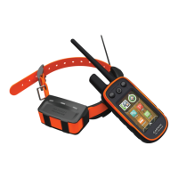
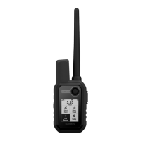
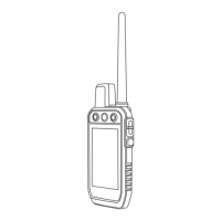
Overview of the Alpha handheld device and its components.
Instructions for installing the battery pack in the dog collar device.
Using status page, acquiring satellites, and methods to add dog collars.
Methods for adding dog collars via wireless pairing, track/control codes, and VHF.
Viewing dog locations on map, understanding status icons, and using the tracking compass.
Setting, editing, and managing location alerts, and enabling dog data broadcast.
Contact points, training methods, intensity levels, and key customization.
Collar training basics and connecting to smartphones/networks.
Using Garmin Explore, managing contacts, and transmitter operation.
Adding contacts, initiating alerts, sending messages, and managing contact IDs.
Updating contact IDs and performing hunting tasks like marking locations.
Marking locations, hunt metrics, collar lights, rescue mode, and waypoint basics.
Creating, editing, navigating, and deleting waypoints, routes, and tracks.
Deleting tracks, changing track color, navigating to track start, and basic map/compass.
Using map, compass, measuring distance, and finding locations via Where To?.
Elevation plots, altimeter calibration, trip computer, and route/sensor settings.
Setting proximity alarms, calculating area size, and using the competition timer.
Managing, downloading, and enabling maps on the device.
Customizing main menu, favorite bar, and data fields.
Configuring system, display, and accessibility settings.
Customizing tones, dog alerts, and map display options.
Advanced map settings and track recording/auto-save configurations.
Configuring routing, sensors, units of measure, and position formats.
Accessing regulatory info, getting support, and updating device software.
Device care instructions, including cleaning the body and touchscreen.
Detailed device specifications and important battery information.
Deleting files, resetting settings, and accessing appendix items like accessories.
Information on accessories, pairing sensors, and maintaining cables.
Detailed descriptions of various data fields available on the device.
Critical warnings regarding battery handling and device usage to prevent injury.
Notices on battery disposal, GPS restrictions, environmental programs, and compliance.
Terms of the software license agreement and limited warranty details.
Details on warranty exclusions, international purchases, and obtaining service.
| Water rating | IPX7 |
|---|---|
| High-sensitivity receiver | Yes |
| Ability to add maps | Yes |
| Battery type | Rechargeable lithium-ion |
| Memory/History | 16 GB |
| Dog tracking range | 9 miles (depending on terrain) |
| Preloaded maps | Yes (TOPO U.S. and Canada) |
| External memory storage | microSD card slot |
| Connectivity | Bluetooth, ANT+, Wi-Fi |
| GPS | Yes |
| Training Features | Yes, includes tone, vibration, and stimulation training features |