Do you have a question about the Garmin Alpha 300i and is the answer not in the manual?
Steps to configure the Alpha system before use.
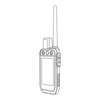
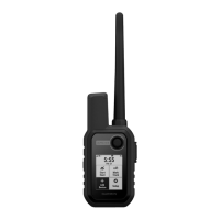
Description of the Alpha handheld device components and keys.
Instructions for charging the Alpha handheld device battery.
Instructions for charging the dog collar device battery.
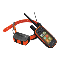
Various methods to pair a dog collar device with the handheld navigator.
Step-by-step guide to wirelessly pair a dog collar with the Alpha navigator.
Process to share dog collar data wirelessly using ANT+ technology.
How to view your dog's location on the map interface.
Explanation of icons used to represent the dog's current status.
Using the compass to navigate and determine direction to your dog.
Guidance on choosing and fitting the correct contact points for your dog's collar.
Overview of available stimulation types: momentary, continuous, tone, and vibration.
How to determine the appropriate stimulation level for collar training.
Sending and receiving text messages via the Iridium satellite network.
How to send predefined check-in messages to contacts.
Procedure for initiating an SOS rescue and communicating with emergency services.
Saving your truck's location for later navigation.
View active hunt time, distance, and dog status during a hunt.
Activating the LED light on the collar for visibility.
Creating, saving, and managing location points on the device.
Planning and navigating sequences of waypoints to a destination.
Recording and viewing your path or movement history.
Understanding and using the map display for orientation and tracking.
Utilizing the device's compass for directional guidance.
Finding and navigating to various destinations using the menu.
Creating alerts for when you or your dogs enter a specific radius.
Viewing GPS accuracy, satellite locations, and signal strength.
Downloading and managing map data on the device.
Personalizing the order and content of the main menu.
Configuring various system-level options like language and units.
Adjusting screen brightness, timeout, and appearance.
Information on obtaining software updates and support resources.
Guidelines for maintaining and cleaning the device to prevent damage.
Technical details and performance specifications for the device.
Tips and settings to extend battery performance for both devices.
Methods to conserve power during the charging process.
Instructions for installing a microSD card for storage.
Steps to connect the device to a computer for data transfer.
Information on acquiring optional accessories for the device.
Details on downloading and using additional map products.
Definitions and descriptions of various data fields available on the device.
| Display Size | 3.5 inches |
|---|---|
| Display Resolution | 282 x 470 pixels |
| Battery Type | Rechargeable lithium-ion |
| Water Rating | IPX7 |
| Memory | 16 GB |
| Ability to Add Maps | Yes |
| High-Sensitivity Receiver | Yes |
| GPS | Yes |
| Display Type | Transflective, color TFT touchscreen |
| Battery Life | Up to 55 hours (up to 20 hours with inReach technology enabled) |
| Weight | 9.9 oz (280 g) with antenna and battery pack |
| Connectivity | Wi-Fi, Bluetooth, ANT+ |
| Preloaded Maps | Yes |
| Interface | Touchscreen |
| inReach Features | Yes |
| Dog Tracking | Yes, up to 20 dogs |
| Compatibility | Compatible with Garmin dog devices |
| External Memory Storage | microSD™ card (not included) |