Do you have a question about the Garmin Aera 760 and is the answer not in the manual?
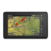
Describes the Garmin aera 760 unit, its display, and primary functions.
Covers initial setup, battery charging, mounting, and unit power on/off procedures.
Explains touchscreen interaction, scrolling, panning, and main menu navigation.
Details how to access option menus and navigate system settings.
Covers map viewing features like range, panning, and overlays.
Explains how to adjust display, sound, map, and other system parameters.
Overview of the navigation map, its data, orientation options, and display features.
Details the three-dimensional terrain view and its operational aspects.
Explains VNAV function for vertical navigation and its configuration.
Covers map orientation, airport/city display, and airway settings.
Information on viewing airport, VOR, NDB, intersection, and user waypoint data.
Instructions for navigating directly to a destination, including holds.
Overview of building and managing flight plans with waypoints and approaches.
Steps to build a flight plan, including adding waypoints.
Covers storing, activating, copying, and deleting flight plans.
Details on loading and managing departure, arrival, and approach procedures.
Explains weather data sources, products, NEXRAD, winds, and temperatures aloft.
Covers terrain display, color codes, alerts, and obstacle information.
Details TIS-A, ADS-B, traffic symbology, alerts, and motion vectors.
Information on viewing terminal procedure charts like ChartView and FliteCharts.
Describes the SafeTaxi feature for enhanced airport taxiway detail.
Details on accessing airport statistics, FBO information, and services.
Covers SiriusXM Radio compatibility, activation, and usage.
Lists system messages, alerts, and definitions for data field options.
Guidance on connecting to a computer, managing files, and updating databases.
Details on mounting the unit, connecting cables, and interfacing with other devices.
Information on battery life maximization, charging, and unit maintenance.
Explains PDF viewer, flight log, track log, E6B calculator, and aircraft profiles.
| Display Size | 7 inches |
|---|---|
| Resolution | 1024 x 600 pixels |
| Battery Life | Up to 4 hours |
| Connectivity | Wi-Fi, Bluetooth, USB |
| WAAS Receiver | Yes |
| Weather Support | Yes, with subscription |
| Voice Control | No |
| Display Type | Touchscreen |
| Preloaded Maps | Yes, worldwide |
| GPS Receiver | High-sensitivity receiver |
| Charts | Aviation charts |
| Data Subscription | Required for some features |
| Traffic Support | Yes, with subscription |
| Mounting Options | Suction cup, yoke mount |