Do you have a question about the Garmin aera 560 and is the answer not in the manual?
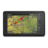
Describes the aera's aviation mode features and display.
Covers battery installation and initial setup procedures.
Explains basic touchscreen and keypad controls for navigation.
Details how to use option menus and enter data.
Covers map range adjustment, panning, and overlays.
Explains how to configure display, sound, units, and other system parameters.
Allows filtering airports by surface type and runway length.
Details how to view current location and use simulator mode.
Introduces the Navigation Map and its orientation options.
Explains the graphical Horizontal Situation Indicator and its settings.
Describes VNAV settings for creating a 3D vertical navigation profile.
Covers map orientation and customizing airports, cities, and roads.
Details how to find, select, and view airport and waypoint information.
Explains how to navigate directly to a single point or airport.
Introduces flight plan creation and data fields.
Guides on creating active and stored flight plans with waypoints.
Explains how to store and view saved flight plans.
Covers activating stored plans, legs, and editing speed/fuel flow.
Details loading and selecting approach procedures for navigation.
Discusses weather sources (XM, FIS-B) and weather products.
Explains terrain display, color codes, and alert settings.
Covers Traffic Information Service (TIS-A) and ADS-B traffic display.
Provides detailed airport taxiway information and hot spot identification.
Offers airport statistics, FBO information, and local attractions.
Details XM radio features, channel selection, and favorites management.
Lists system messages, alerts, and definitions for data fields.
Covers loss of GPS signal and terrain display issues.
Explains connecting to a computer, managing files, and databases.
Covers mounting, connecting to radios, transponders, and data links.
Provides guidance on battery life, cleaning, and unit protection.
Details TIS-A service, symbology, limitations, and data sources.
Covers flight logs, track logs, heading lines, E6B calculator, aircraft profiles, weight/balance, EPE circle, and proximity waypoints.
Illustrates VFR, IFR, and airspace symbols used on the map.
Explains map datums and coordinate system formats.
Provides definitions for technical terms and acronyms used in the manual.
Outlines software license terms and product warranty information.
| Battery | Rechargeable lithium-ion |
|---|---|
| Preloaded Maps | Yes |
| Terrain Awareness | Yes |
| GPS Receiver | High-sensitivity GPS receiver |
| Connectivity | Bluetooth, USB |
| Aviation Databases | Jeppesen |
| Weather Support | XM weather (subscription required) |
| Traffic Support | ADS-B traffic (subscription required) |
| Map Coverage | North America |