Do you have a question about the Garmin AERA 660 and is the answer not in the manual?
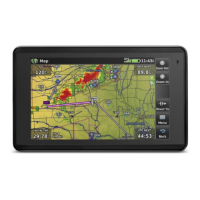
General overview of the aera 660's features and interface.
Initial setup procedures including battery installation and charging.
Basic touchscreen operation, menu navigation, and dedicated page icons.
How to access system features like option menus and data entry.
Understanding map range, panning, overlays, symbols, and detail.
Configuration options for display, sound, maps, connectivity, and other system parameters.
Overview of the Navigation Map display and aircraft icon placement.
Explanation of the 3D visualization of terrain and aircraft relation.
How to use VNAV for vertical flight path planning and altitude management.
Customizing map appearance including orientation, airports, cities, and roads.
Information on selecting, viewing, and accessing details for waypoints.
Initiating direct-to navigation to a single point, quicker than flight plans.
Overview of building flight plans, waypoints, and approaches.
Steps for creating active and stored flight plans with waypoints.
How to store flight plans and view their details.
Activating stored flight plans or specific legs within a flight plan.
Loading and activating approach procedures for navigation.
Selecting weather data sources and understanding weather products.
Using terrain information for situational awareness and understanding color codes.
Displaying traffic data, understanding TIS-A and ADS-B symbology and alerts.
Enhanced map detail for airports showing taxiways, hot spots, and landmarks.
Accessing airport statistics, FBO information, and other directory data.
Using SiriusXM Radio features, compatible devices, and activation.
Connecting to a computer, managing files, and handling databases and software updates.
Mounting the device, connecting to aircraft radios, and understanding interface formats.
Battery information, maximizing life, replacement, and unit care instructions.
| Display Resolution | 480 x 800 pixels |
|---|---|
| Touchscreen | Yes |
| Battery Life | Up to 4 hours |
| Voltage Range | 10-35 V |
| Display Type | WVGA color TFT |
| Connectivity | Bluetooth |
| Preloaded Maps | Yes |
| Weather Updates | Yes |
| Traffic Updates | No |
| Receiver Type | GPS/GLONASS |
| Operating Temperature | -4°F to 131°F (-20°C to 55°C) |
| Weather Support | Yes |
| Traffic Support | No |