Do you have a question about the Garmin aera 795 and is the answer not in the manual?
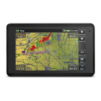
Provides an overview of the aera 795/796 unit and its purpose as a quick reference guide.
Details the initial setup steps, focusing on battery installation.
Instructions for charging the aera 795/796 unit using the aircraft's power outlet.
Explains how to view GPS signal strength on the device.
Instructions on how to change the device's display orientation between Portrait and Landscape modes.
Covers basic operations and user interface elements of the device.
Describes the four dedicated touch icons on the bezel and their functions.
Explains the configurable Page Buttons located above the dedicated icons.
Explains how to access and use the Main Menu and its icons.
Details the functions associated with each icon in the Main Menu.
Describes how to access and use the Nearest Icons to find nearby points of interest.
Explains how to access and view weather products using the Weather Icons.
Lists various weather and flight condition reports available on the device.
Introduces the Tools section and lists its available second-level icons.
Details the third-level icons found within the Setup menu for device configuration.
Explains fundamental touchscreen interactions like touching and selecting.
Instructions for scrolling through lists and panning across maps or charts.
Instructions on how to zoom in and out on touchscreen map displays.
Explains how to navigate and use context-sensitive option menus.
Explains the process and icons used for entering data into the device.
Instructions for selecting data options from vertical or horizontal lists.
How to activate the map pointer and pan across the map display.
Guide on how to view details about features highlighted on the map.
Explains how to adjust the map's zoom level and scale.
Instructions for displaying or removing map overlays like Weather and Terrain.
Covers how to manage and configure flight data fields displayed on the device.
Instructions for changing the information shown in the data fields on the screen.
How to access and configure numeric flight data fields.
Details the Horizontal Situation Indicator (HSI) and panel display features.
Instructions for setting the HSI Bug Indicator from the Map option menu.
How to manually set a course using the 'Set OBS and Hold' option.
Explains the Vertical Navigation (VNAV) feature and its configuration.
Explains how to enable/disable and capture/cancel VNAV profiles.
Steps to configure VNAV profile settings like 'Profile' and 'Altitude'.
Covers searching for, reviewing, and managing waypoints like airports and runways.
How to search for and review airport information using various criteria.
How to search for and review runway information using various criteria.
How to view nearest airports, VORs, NDBs, etc. using the NRST icon.
How to view airport weather information using the WPT Info and WX Tab.
Steps for creating user-defined waypoints by touching a map location.
Instructions for setting a destination and navigating directly to it.
How to set a destination using identifier, name, or city for Direct-To navigation.
How to select a nearby airport for Direct-To navigation using the Nearest Icons.
How to use the map pointer to select a waypoint for Direct-To navigation.
Steps to stop active Direct-To navigation.
Covers how to customize data fields for flight plans.
How to customize the data fields displayed for active and saved flight plans.
Explains how to create new flight plans.
Steps to create a new active flight plan by adding waypoints.
How to create and save a flight plan for later use.
Covers adding waypoints to flight plans.
Instructions for inserting new waypoints into existing flight plans.
Detailed steps for entering waypoints, including search options.
How to add an approach procedure to a saved flight plan.
Covers saving and reviewing flight plans.
How to review details of saved flight plans.
Steps to save the current active flight plan.
How to activate stored flight plans and flight plan legs.
How to activate a saved flight plan from the FPL List.
How to activate a specific leg of an active flight plan.
Covers deleting stored flight plans.
Steps to delete a single stored flight plan.
How to delete all saved flight plans from the device.
Explains how to select and use approach procedures.
How to select and add an approach procedure to an active or saved flight plan.
How to select an approach using the Direct-To function.
Covers viewing SiriusXM Weather products on the device.
How to display SiriusXM Weather products on the device's navigation map.
How to view SiriusXM Weather products on a dedicated weather map.
Details the terrain features and shading options.
Instructions for turning terrain shading on or off on the map display.
How to enable or disable terrain alerts for the device.
Covers the Traffic Information Service (TIS) features and settings.
How to adjust the audio settings for Traffic Information Service (TIS).
How to configure TIS settings directly on the navigation map.
How to view TIS information by using the map pointer on traffic symbols.
Explains the Traffic Warning Window and how to acknowledge it.
Covers recording and managing flight logs.
How to view recorded flight details such as route, date, hours, and path.
Instructions for deleting individual or all flight log records.
Details how to manage track logs.
How to display or hide the track log on the navigation map.
How to adjust settings for track logging, such as record mode and color.
Steps to clear existing track log data.
How to save the current track log data.
Instructions for editing saved track logs, such as renaming or changing color.
Covers the E6B calculator for various aviation computations.
How to access the E6B calculator for flight calculations.
Guide on calculating true airspeed and density altitude using the E6B calculator.
How to calculate winds aloft using true airspeed and heading.
Steps to reset the E6B calculator to its default settings.
Covers managing aircraft profiles.
How to access the aircraft profile settings.
Instructions for creating a new aircraft profile with speeds and fuel flow.
How to select and load a previously saved aircraft profile.
Steps to rename an existing aircraft profile.
How to delete a saved aircraft profile.
Covers performing weight and balance calculations.
Instructions for performing weight and balance calculations for flight planning.
Explains various system messages and their meanings.
Continues the list of system messages and their corresponding comments.
Details messages related to airspace proximity and entry.
Provides definitions for various data fields and numeric data options.
Continues the definitions for data fields and numeric data options.
Refers to the Hazard Avoidance section for information on aural alerts.
Describes what happens when the device loses its GPS signal.
Explains how the hazard display changes when GPS signal is lost.
Outlines the software license agreement and warranty terms for the device.
Details the terms and conditions for using the embedded software.
Specifies the warranty period and conditions for product defects.
Information regarding Garmin's liability limitations for product use.
Disclaimer regarding the AOPA airport directory information.
Terms and conditions for the Sirius XM Satellite Radio service.
Warranty information specifically for the weather data software.
Safety precautions related to the use of Sirius XM Services.
Compliance information regarding FCC rules for digital devices.
Compliance information regarding Industry Canada standards for radio devices.
| Aviation | Yes |
|---|---|
| Marine (chartplotters, sounders) | No |
| Routes quantity | 50 |
| Number of waypoints | 3000 |
| Traffic Message Channel (TMC) | - |
| Power source type | Battery |
| Battery life (max) | 3 h |
| Storage media type | SSD |
| Compatible memory cards | SD |
| Display diagonal | 7 \ |
| Display resolution | 480 x 800 pixels |
| Display size (HxV) (imperial) | 3.6 x 6 \ |
| Form factor | Fixed |
| Product color | Black |
| Depth | 38 mm |
|---|---|
| Width | 130 mm |
| Height | 203 mm |
| Weight | 748 g |