EasyManua.ls Logo

Garmin E Trex 30 User Manual

Garmin E Trex 30
5 pages
To Next Page IconTo Next Page
Page #1 background imageLoading...
Page #1 background image
Using E Trex 30 for Crashed Model Location.
Basic Concepts
Immediately after the crash memorise the direction of the crash and esti-
mate the distance into the bush. (Lay your Tx on the ground with the an-
tenna pointing in the direction of the crash)
To help distance estimation the following will assist:

Length of Runway: 200 m

Distance from the pilots station to the cabbage trees opposite: 168m

Distance from the pilots station to the Astro dome: 275m
Both these features and the pilot station have been entered as way
points in the E Trex
Stand at the pilot station, Start up the Etrex, from the MENU page select
the Sight ‘N Go feature. Enter the crash direction and its distance esti-
mate. This creates a numbered waypoint, which is the crash site. You can
name this waypoint if required, otherwise remember its ID Number.
Press the “save” selection which brings up the compass page to allow-
navigation to the crash waypoint.
You can then use the compass display or the map display to guide you to
the crash waypoint.
The top pointer on the compass is the COURSE POINTER which points in
the direct bearing to the crash and the “dashboard” data fields tell you how
far away you are.
If you have to deviate from the direct course (e.g. to avoid an obstacle) the
course pointer always indicates the direction from your current position.
A course deviation indicator (CDI) also provides a indication of right and
left drift from the original direct course from the pilots station. If you want
to follow a direct line to the crash the CDI helps you to do this.
If you select the map option the map shows where you are in relation to
the pilot station and the crash waypoint and also points to the crash way-
point.
The tracking feature of the GPS will show your track on the map display
as you make diversions etc on the way to the waypoint.
Use the tracking feature to search closer or further away from the pilots
station in the bearing line of the crash waypoint.
Question and Answer IconNeed help?

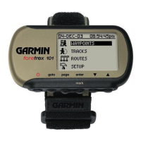
Do you have a question about the Garmin E Trex 30 and is the answer not in the manual?

Garmin E Trex 30 Specifications

General IconGeneral
Display Resolution176 x 220 pixels
Battery Lifeup to 25 hours
Water RatingIPX7
High-Sensitivity ReceiverYes
Barometric AltimeterYes
Electronic CompassYes
BasemapYes
Ability to Add MapsYes
Built-in Memory1.7 GB
Waypoints/Favorites/Locations2000
Routes200
Track Log10, 000 points, 200 saved tracks
Geocaching-FriendlyYes
Custom POIs (points of interest)Yes
Picture ViewerNo
Garmin Connect CompatibleYes
Wireless ConnectivityNo
Dimensions4.0 x 2.1 x 1.3 inches
Display TypeTransflective color TFT
Weight5 oz (141.7 g) with batteries
Battery2 AA batteries
Accepts Data CardsmicroSD card (not included)
Display Size1.4" x 1.7" (3.6 x 4.3 cm)

Summary

Using E Trex 30 for Crashed Model Location

Basic Concepts for Crash Location

Initial steps and distance estimation aids for locating a crashed model using the E Trec 30 GPS.

Using Sight 'N Go for Crash Site

Step-by-step guide on using the 'Sight 'N Go' feature to create a waypoint for the crash site.

Starting and Operating the E Trex

Device Overview and Keys

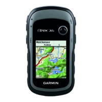
Visual guide to eTrex 30 components and instructions for using its keys and thumb stick.

Powering On/Off and Satellite Acquisition

Guide on turning the device on/off and acquiring satellite signals for positioning.

Waypoint Management Operations

Procedures for creating, finding, editing, and deleting waypoints on the eTrex 30.

Navigating with Sight 'N Go

Entering and Navigating to a Location

Steps to use Sight 'N Go to point, lock direction, and navigate to a destination.

Using Map and Compass Displays

How to use map and compass views for navigation and checking progress.

Course Deviation Indicator (CDI)

Using the CDI to maintain a direct course and indicate left or right drift.

Compass Features and Navigation

Electronic Compass Functionality

Details on the eTrex 30's 3-axis electronic compass and navigation pointers.

Navigating with Bearing Pointer

Instructions on using the bearing pointer to navigate to a destination.

Understanding Course Pointer and CDI

Explanation of the course pointer and course deviation indicator (CDI) for navigation.

Navigation Settings and Map Usage

Heading Settings Configuration

Configuration options for compass display, north reference, and pointer types.

General Navigation Methods

How to navigate to destinations using routes, tracks, or saved locations via map or compass.

Navigating to a Destination

Step-by-step process for selecting and navigating to a chosen destination.

Browsing and Customizing the Map

Instructions on panning, zooming, and customizing map display settings.

Related product manuals