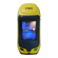
The Qstar series high-precision mobile GIS product is a robust and versatile device designed for GIS data acquisition and navigation. It integrates a comprehensive set of features within an industrial-grade design, making it suitable for demanding field environments.
Function Description:
The Qstar series serves as a high-precision mobile GIS data collector, offering both navigation and GIS data acquisition capabilities. It supports input in both Chinese and English through its physical buttons and touch screen interface. The device is built to industrial standards, capable of withstanding drops from 1.5 meters onto cement without damage and boasting an IP67 rating for dust and waterproofing, ensuring reliable operation in complex field conditions.
Key integrated functions include:
- GPS Navigation and Positioning: Provides high-precision GPS capabilities for accurate location tracking.
- Embedded Windows Mobile 6.5 System: Runs on a familiar operating system, allowing for a wide range of applications.
- Digital Camera: A built-in 5-megapixel camera with LED fill light enables image information acquisition on-site, automatically linking GPS coordinates and image data for labeling.
- Microphone: Allows for the collection of voice information on-site.
- Speech Play Function: Supports audio output for various applications.
- Bluetooth Communication: Facilitates wireless data transmission with other devices.
- 3G Wireless Communication (Optional): Enables communication between the management center and the mobile GPS terminal, supporting data communication and phone voice calls.
- Large Storage: Includes 8GB of flash memory and supports MicroSD card expansion up to 32GB for storing collected data and program files.
- USB Port: For data transmission and connecting to a computer.
- RFID Writing and Reading Modules (Optional): For specific data collection needs.
- Bar Code Scanner (Optional): For efficient data entry.
Important Technical Specifications:
- Operating System: Windows Mobile 6.5
- CPU: 806MHz high-speed CPU
- Memory: 256MB RAM
- Flash Memory: 8GB
- Screen: 3.7-inch color touch screen with 640 x 480 resolution.
- GPS Characteristics:
- High sensitivity GPS positioning technology.
- GPS+GLONASS binary star positioning technology.
- Supports SBAS (WAAS, EGNOS, MSAS).
- Positioning time for the first fix: 30 seconds (typical).
- Positioning Accuracy:
- Point positioning: 5 meters.
- SBAS: 1-3 meters.
- Camera: 5 million pixels with LED fill light.
- Battery: Standard configuration 3.7V, 8800 mAh lithium battery (BL-8800A model).
- Battery Life: Can work continuously for over 12 hours, supporting online charging.
- Physical Properties:
- Keys: 10 buttons, including four direction keys and a shortcut key on the side.
- Size: 14cm × 8cm × 3.5cm.
- Weight: 360g (contains battery).
- Work Temperature: -30°C to +70°C.
- Storage Temperature: -40°C to +80°C.
- Dustproof/Waterproof: IP67.
- Shockproof: Resistance to 1.5m free fall.
- Interfaces: Mini USB interface, SIM card socket, MicroSD card slot.
- Wireless Connectivity: WIFI (802.11b/g).
Usage Features:
- Intuitive Operation: Most settings and operations can be performed using the touch pen, while common tasks can be handled via the keyboard.
- Keyboard Functions: Includes a confirmation button ("ENT"), exit key ("ESC"), F1 function keys, a switch machine key, and direction keys for navigation.
- Backlight Control: The switch machine button can also control the backlight (short press for 1 second) to save power.
- Power On/Off: Long press the switch machine button for more than 3 seconds to turn the device on or off.
- Data Storage: MicroSD cards (up to 32GB) can be used for storing collected data and program files. Users should distinguish between MicroSD cards and common SD cards.
- Network Connection: Supports dial-up network connections via the "DialConnect" option in the "start" menu.
- Data Transfer: Utilizes Microsoft ActiveSync for connecting to a PC via USB, allowing for data download and file management.
- Application Functions: The device is equipped with Hi-Q software for utilizing its various application functions, including GPS navigation, digital camera, microphone, and 3G communications.
Maintenance Features:
- Durability: Constructed with corrosion and impact-resistant materials, designed for industrial use.
- Environmental Protection: The device should be kept in a dry environment and protected from extreme conditions such as dampness, high/low temperatures, and corrosive gases or liquids to ensure stability and extend its lifespan.
- Temperature Range: Must be preserved and used within stipulated temperature ranges (Work: -30°C to +70°C; Storage: -40°C to +80°C).
- Satellite Signal Reception: For continuous observation and quality, stations should be set in open places, avoiding barriers exceeding 15 degrees.
- Electromagnetic Interference: To reduce interference to GNSS satellite signals, avoid strong electromagnetic interference sources (e.g., TV towers, microwave stations, high voltage transmission lines) within 200 meters.
- Multipath Effect Reduction: Stations should be located away from terrains that strongly reflect electromagnetic wave signals, such as high buildings or sliced waters.
- Interface Protection: When the charging and USB interfaces are not in use, the stoppers should be covered to ensure waterproof and dustproof protection.
- Horn Maintenance: If the horn gets wet, it may sound silent or husky; drying it will restore normal function. The loudspeaker and instrument are completely waterproof, and water in the horn will not affect performance, but timely drying is recommended.
- Battery Care:
- Use only approved chargers (CL-00A model).
- Charge within a temperature range of 10°C to 40°C.
- For first-time use, fully discharge the battery before charging, and perform three initial charges of 12 hours each. Subsequent charges should be 6 hours.
- If not used often, charge once a month.
- Do not put the battery into fire or short-circuit metal electrodes.
- Replace the battery if it shows signs of fever, deformation, discharge, smell, or other abnormal phenomena during use or storage.
- Replace the battery if its use time significantly shortens, indicating aging.
- For environmental protection, return failed lithium batteries to Hi-Target or professional recycling units.
- Data Cable Care: When not in use, the data cable should be packed in a place where it is not easily squeezed to prevent damage to the plug.
- Antiskid Belt: The device is equipped with an antiskid belt to prevent sliding during operation, which should be entangled when working.