4 IKE 4 User Manual
Thank you for purchasing the IKE 4. Your IKE 4 is a location-based measuring solution that will
greatly increase your productivity when undertaking utility asset management surveys and
related measurements. The IKE 4 device integrates a digital camera, compass, laser range
nder, mobile computer, and precision GPS. This data can be uploaded into our cloud-based
IKE Ofce software where additional measurements and annotations can be made.
With your IKE solution you can quickly:
ĥ Collect geo-located pole photos
ĥ Measure wire span heights, even across busy roads
ĥ Determine wire clearances from vegetation or buildings
ĥ Make accurate attachment height measurements on captured photos
This document will guide you through:
ĥ Setting up your IKE system
ĥ Creating in-eld measurement tasks
ĥ Transferring data from the IKE Field to IKE Ofce
ĥ Measuring attachment heights from a photo
ĥ Outputting data in industry standard le formats
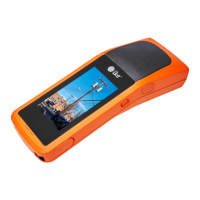
The IKE 4 product includes:
ĥ IKE Device
ĥ Hard case
ĥ Tripod set with carring bag
ĥ Accessories: carrying straps, AC wall charger, car
charger, charging cable, USB cable, screw driver.
ĥ Software: IKE Field, IKE Ofce, IKE Integration
Introduction
What’s in the box