Do you have a question about the Leica Geosystems GS14 and is the answer not in the manual?
Location of model and serial number for support.
Lists available manuals like Quick Guide and User Manual.
Access services, information, and training material via the myWorld portal.
Explains how safety directions help avoid hazards and ensure proper use.
Explains the purpose and types of warning messages in the manual.
Defines intended uses, foreseeable misuses, and environmental operating limits.
Outlines user responsibilities and details hazards like electrocution and general use.
Details hazards like distraction, securing, lightning strikes, and accessories.
Discusses product function in electromagnetic environments and potential disturbances.
Details FCC (US) and ICES-003 (Canada) compliance statements for the device.
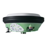
Lists main components like Instrument, Web server, Antenna, and software.
Details GS firmware, language, software upload, and instrument power options.
Describes microSD data storage and lists all items included in the product container.
Details the physical components of the GS14/GS16 instrument.
Explains the functions of the ON/OFF and Function buttons.
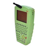
Describes how the instrument is operated via buttons or field controller.
Details instrument operation methods using its buttons or the connected field controller.
Describes fundamental setup procedures for the instrument for various operations.
Guides for setting up as Post-Processing and Real-Time base stations.
Instructions for setting up the instrument as a real-time rover for extended field use.
Guides for connecting to a PC via USB and accessing the instrument's web server.
Details how to attach a field controller to a holder and pole.
Covers battery operating principles, charging, changing, and storage.
Instructions for inserting and removing microSD cards and SIM cards.
Explains the meaning of different LED indicators on the instrument.
Provides tips for achieving accurate GNSS survey results and proper instrument setup.
Guidelines for safely transporting the equipment in various scenarios.
Recommendations for storing, cleaning, and drying the instrument and its accessories.
Details satellite reception and supported signals for GS14 and GS16 models.
Explains accuracy factors and provides physical dimensions and weight of the instrument.
Details power consumption and estimated operating times for the instrument.
Covers operating/storage temperatures, water/dust protection, and humidity specs.
Details compliance with FCC (US), EU directives, and Japanese radio and telecom laws.
Lists supported frequency bands and output power levels for GNSS, Bluetooth, and Radio.
Information on handling Lithium batteries for transport according to IATA Dangerous Goods Regulations.
Outlines terms and conditions for product software usage, warranty, and licensing.
Identifies external instrument ports and details pin configuration for port P1.
| Type | GNSS Receiver |
|---|---|
| RTK Positioning Accuracy (Horizontal) | 8 mm + 1 ppm |
| RTK Positioning Accuracy (Vertical) | 15 mm + 1 ppm |
| Static Positioning Accuracy (Horizontal) | 3 mm + 0.5 ppm |
| Static Positioning Accuracy (Vertical) | 5 mm + 0.5 ppm |
| Data Update Rate | Up to 20 Hz |
| Operating Temperature | -40 °C to +65 °C |
| Protection Class | IP67 |
| Battery Type | Li-ion |
| Battery Life | Up to 10 hours |
| Frequency Bands | GPS L1, L2; GLONASS L1, L2; Galileo E1, E5a; BeiDou B1, B2 |
| Signal Tracking | GPS, GLONASS, Galileo, BeiDou |
| Positioning Accuracy (SBAS) | Less than 1 m |
| Communication | Bluetooth |