Do you have a question about the Leica DIGICAT 100 and is the answer not in the manual?
Congratulations on your purchase and details about the DIGICAT instrument.
Information on how to identify the product model and serial number.
Explanation of symbols used in the manual and trademark information.
References to DIGICAT instruments and DIGITEX signal generators.
Details on the instrument label and its relation to the manual.
Explanation of why underground service location systems are required.
Purpose of detecting and locating underground services.
Using plans, drawings, and electromagnetic location for service detection.
How DIGICAT detects signals and its various operating modes.
Availability of depth measurement and wireless communication features.
User-friendly design and the importance of site diagrams.
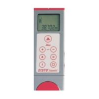
Overview of the DIGICAT's physical controls and their functions.
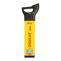
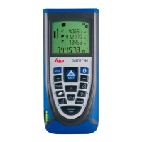
Detailed explanation of the DIGICAT 200 display panel and controls.
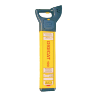
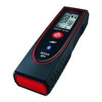
Detailed explanation of the DIGICAT 100 display panel and controls.
Recommended steps for effective and safe operation of the DIGICAT.
Cautions for use and step-by-step guide for battery replacement.
List of DIGICAT operating modes including Power, Radio, and DIGITEX.
Description of Power mode and Radio mode frequencies and usage.
Details on DIGITEX 8 kHz and 33 kHz modes for tracing services.
Usage of 33 kHz for depth measurement and wireless data transfer.
Performing startup tests and overview of the locating process steps.
Step-by-step guide for conducting a sweep search with the DIGICAT.
Techniques for pinpointing service locations with DIGICAT 200 and 100.
Methods for finding service direction and performing radio mode sweeps.
Procedure for measuring the depth of underground services.
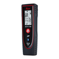
Interpreting depth codes and wireless data transfer on DIGICAT 200GIS.
Introduction to the DIGISYSTEM product collection and accessories.
Information on the DIGITEX signal generator and its function checks.
Details on Signal Clamp, Property Connection Set, and DIGITRACE.
Description of DIGIMOUSE sonde and DIGITEX Induction mode.
Procedures for using DIGITEX Connection mode and safety warnings.
Specific applications of Signal Clamp, PCS, and DIGITRACE accessories.
Understanding signal differences and locating the DIGIMOUSE.
Step-by-step method for accurately locating a DIGIMOUSE.
Overview of wireless data transfer, output, and general information.
Recommendations for transporting and storing the DIGICAT equipment.
Procedures for cleaning and drying the DIGICAT and its accessories.
General safety directions, purpose, permitted, and adverse use.
Warnings on product use, environmental limits, and responsibilities.
Duties of personnel, warranty, and hazards associated with use.
Cautions on erroneous results, electrocution risk, and dynamic applications.
Warnings on depth accuracy, signal clamp danger, electric shock, and site security.
Safety precautions for product disposal and battery handling.
Warnings on battery stress, short circuits, and electromagnetic compatibility.
Cautions on using third-party accessories and electromagnetic radiation.
Safety warnings related to the product's internal radio communication.
FCC compliance statement for US and warning against unauthorized modifications.
Typical detection ranges and operating depth ranges for DIGICAT modes.
Depth accuracy specifications and operating reception frequencies.
Specifications for the display panel, keypad, and speakers.
Details on internal battery type and typical operating time.
Instrument dimensions, weight, and environmental ratings.
Conformity to regulations and frequency band usage.
Output power and wireless communication specifications for DIGICAT 200GIS.
Purpose of the functional check procedure for DIGICAT performance.
Steps for checking unit functionality, display, and batteries.
Procedure for verifying passive modes functionality.
Verification of active modes, depth, and wireless functions.
List of functional test items for casing, labels, battery, and display.
List of functional test items for batteries, modes, and depth.
Procedure for pairing DIGICAT 200GIS with a wireless network.
Contact information and resources for system developers.
Description of data format suitable for logging in GIS systems.
Explanation of the serial data string output format for DIGICAT.
Format of data string output during normal operation.
| Brand | Leica |
|---|---|
| Model | DIGICAT 100 |
| Category | Security Sensors |
| Language | English |