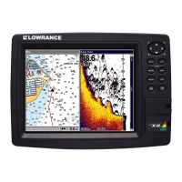
Do you have a question about the Lowrance HD LCX-110C and is the answer not in the manual?
Explains the basics of sonar technology and how it works.
Explains the basics of GPS technology and how the unit receives signals.
Introduces GPS and WAAS systems and their role in navigation.
Explains the formatting and conventions used in the manual for clarity.
Outlines the recommended sequence for preparing and installing the sonar/GPS unit.
Provides detailed instructions for installing the sonar transducer on various boat types.
Lists recommended tools and supplies needed for installation.
Guides on choosing the optimal location for transducer mounting.
Compares shoot-thru-hull and transom mounting methods for transducers.
Details the assembly and mounting process for transom transducers.
Describes the installation process for an optional speed/temperature sensor.
Explains the installation and connection of the GPS antenna/receiver module.
Details how to connect the unit to power sources and manage power cables.
Covers options for mounting the main unit, either with a bracket or in-dash.
Explains how to install and use MMC or SD cards for data storage.
Lists and describes other available accessories.
Describes the functions of each key on the unit's keyboard.
Details how to turn the unit on and off and control its backlight.
Explains the structure and functions of the unit's main menu.
Describes the different page displays (Satellite Status, Navigation, Map, Sonar).
Provides a simplified, step-by-step reference for common fish-finding situations.
Explains the ASP feature for noise reduction and its settings.
Details the different types of alarms (Fish, Zone, Depth) and how to configure them.
Explains how to calibrate the speed sensor for accurate readings.
Describes the chart speed setting and its effect on the display.
Explains how ColorLine helps distinguish echoes and targets based on signal strength.
Explains how to use the depth cursor to measure target depths.
Details how to use and adjust automatic depth ranging for optimal display.
Explains how to manually set depth ranges for detailed viewing.
Describes how to set custom upper and lower depth limits for focused viewing.
Explains the FasTrack feature for rapid updates and ice fishing.
Details the Fish I.D. feature for identifying fish with symbols and its limitations.
Explains the FishTrack feature that shows the depth of fish symbols.
Explains how to change transducer frequency (200 kHz vs 50 kHz) for different depths.
Refers to Ping Speed controlling HyperScroll for faster screen updates.
Explains how to save sonar data logs to an MMC card for later playback.
Refers to ASP for noise rejection.
Describes how to add or remove data overlays on the display.
Explains how to change overlay data display between digital and analog gauges.
Explains Ping Speed and how it relates to HyperScroll mode.
Details how to restore all settings to factory defaults.
Explains how to reset the water distance measurement to zero.
Explains how to calibrate depth readings based on transducer mounting depth.
Describes how to adjust sensitivity for optimal sonar signal clarity.
Explains how to change the color scheme and display modes for the sonar chart.
Lists the available sonar page display options like Full Sonar Chart.
Provides steps to diagnose and resolve issues when the unit does not power on.
Explains how to exit demo mode, usually related to disconnected sensors.
Offers solutions for unit freezing, locking up, or erratic operation, often due to electrical noise.
Addresses problems with weak bottom echoes, erratic readings, or lack of fish signals.
Solves issues with bottom echo loss at high speeds or erratic readings when moving.
Addresses missing fish arches when Fish I.D. is off, often related to sensitivity or zoom.
Explains how electrical noise affects sonar display and methods to identify and minimize it.
Describes the functions of each key on the unit's keyboard.
Details how to turn the unit on and off and control its backlight.
Explains the structure and functions of the unit's main menu.
Describes the different page displays (Satellite Status, Navigation, Map, Sonar).
Provides a quick reference for basic GPS operations and navigation.
Explains how to measure the distance from the current position to a selected location.
Details how to measure the distance between any two points on the map.
Describes how to create, use, and delete icons on the map for marking locations.
Explains what routes are and how they are used for navigation.
Details the GPS alarms (Arrival, Off Course, Anchor) and their settings.
Explains how the unit automatically searches for and acquires satellite signals.
Describes how to view MMC files and check available storage space.
Explains how to configure communication ports for data transfer with other devices.
Details how to configure NMEA sentences for specific data transmissions.
Explains how to select coordinate systems (Degrees, UTM, MGRS, etc.) for position display.
Describes how to use Map Fix to find your position relative to a reference on a printed map.
Explains how to customize data boxes on page displays for on-screen information.
Describes how to use the GPS simulator for practice and testing navigation features.
Explains how to hide GPS menus and features when no GPS antenna is connected.
Describes how to set a starting position for the GPS unit, simulating a different location.
Explains the auto zoom feature that adjusts map scale during navigation.
Details options for map display, including turning maps on/off, pop-up info, and map boundaries.
Explains how to set map orientation (North Up, Track Up, Course Up).
Describes how to display Navionics electronic charts from an MMC card.
Explains how to view port services information indicated by anchor icons on maps.
Describes how to view tidal current data using icons on Navionics charts.
Explains how to view tide station information and daily tidal data.
Explains how to search for specific addresses using the unit.
Describes how to find information about any item selected on the map via the cursor.
Details how to search for and locate interstate highway exits and services.
Explains how to search for various points of interest (POIs) on the map.
Details how to search for specific streets and intersections on the map.
Explains how to search for saved waypoints by name or nearest location.
Lists the various geodetic datums supported by the unit.
| Sonar Frequency | 50/200 kHz |
|---|---|
| Sonar Capability | Yes |
| Chartplotting | Yes |
| Water Resistance | IPX7 |
| Display Type | Color LCD |
| RMS Output Power | 500 watts |
| Peak to Peak Output Power | 4000W |
| Power Output | 12V |
| Memory | Internal |
| Display Size | 10.4 in |