Do you have a question about the LXNAV LX90 Series and is the answer not in the manual?
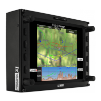
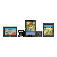
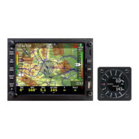
Provides an overview of the LX9xx/LX80xx series, detailing the main display unit, vario unit, and optional components.
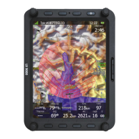
Describes the features of the main display unit, including screen brightness, OS, input controls, orientation, and pre-loaded data.
Details the specifications and capabilities of the V9 Vario Unit, including its processor, display, sensors, and audio output.
Outlines the features of the V8 Vario Unit, covering its screen, processor, sensors, audio output, and optional capabilities.
Describes the V80 Vario Unit's features, including its screen, processor, sensors, audio output, and optional functionalities.
Describes the physical controls on the main display unit, including rotary knobs and push-buttons.
Guides the user through the power-on procedure, including boot loader, kernel, and file system screens.
Explains the various input controls used in the user interface for data entry and menu navigation.
Provides recommended methods for safely shutting down the LX90xx system.
Details the Setup Mode for configuring the main display unit and connected devices.
Explains the QNH and RES settings, crucial for final glide calculation accuracy.
Explains the Safety Altitude setting, which is the reserve altitude added to the final glide calculation.
Details the MacCready values for speed to fly and final glide calculation, including Safety Mc and Mc-offset.
Explains how Safety Mc value is used for final glide calculation, independent of speed to fly calculations.
Describes the Safety Mc-offset feature, which adds safety based on distance to the target.
Describes the IGC-approved built-in flight recorder and its capabilities for secure flight records.
Details the settings for vario parameters, including needle filter, sound filter, and vario range.
Explains how to control screen brightness, including automatic and manual settings.
Guides the user on managing waypoint, airspace, and airport databases, and recorded flights.
Explains how to load user airspace and waypoints from SD card, USB stick, or LXNAV Connect storage services.
Details how to upload the free LXNAV airport and airspace database (.asapt files).
Explains how to select, enable, and manage airspace files for display and proximity warnings.
Explains how to select and manage airport databases, including adding new airports via LXAsapt Editor.
Covers managing waypoint files and tasks, including selection, activation, and loading.
Explains how to use terrain and vector map data, and load scanned maps for navigation.
Describes how to view, copy, and delete stored flights, and options for sending flights via email or OLC.
Explains the automatic upload of flight files to OLC (Online Contest) and SeeYou Cloud.
Explains how to upload databases such as airspace, airports, and FlarmNet files.
Allows definition of map appearance in navigational mode, including terrain, airspace, and weather layers.
Explains how to configure map display, terrain shading, label zoom, and colour schemes.
Details the Weather menu, enabling real-time weather data via Wi-Fi, including Satellite, Forecast, and Rain radar layers.
Allows definition of airspace map presentation, including display options, zone disabling, and type-specific settings.
Defines the look and feel of waypoints and airports on the navigational pages, including display options and labels.
Configures the display of the flown path, current track vector, and target vector with collision warnings.
Enables and configures the special thermal page that appears when circling in a thermal.
Defines how a task is drawn in task mode, including colours, flown task display, and observation zones.
Allows modification of the FLARM radar display, including object presentation, colours, and labels.
Enables configuration of audio settings, voice prompts, and alarm sounds for the vario unit.
Allows configuration of audio alarms for various events like airspace proximity, FLARM, and time intervals.
Defines the geometry and parameters for observation zones used in tasks (start, turn, finish).
Allows adjustment of flight path optimization rules according to OLC or FAI rules.
Covers configuration of airspace, altitude, FLARM, time, gear, and waypoint warnings.
Explains the complex triggers and settings for airspace warnings, including buffer zones.
Details altitude warning settings based on MSL projection and vertical speed.
Explains FLARM warning types (traffic, obstacles, alert zones) and alarm levels (low, medium, high).
Enables definition of hardware properties like TE compensation, vario indicators, compass, and FLARM module settings.
Covers settings related to the glider, including TE compensation, temperature offset, and airspeed offset.
Details digital and pneumatic TE compensation methods and procedures for fine-tuning.
Guides on setting up vario indicators, including I9, I8/I80, and LCD/USB-D types.
Details the I9 indicator, its mechanical needle, colour screen, and selectable data.
Describes the I8/I80 indicators without mechanical needles and their screen-based data display.
Explains how to set up the numeric screen and navboxes on the main display unit.
Covers FLARM setup, operation modes (Power OFF, Power ON, Stealth ON), and port configuration.
Explains how to use profiles for storing settings and navigational page layouts, and managing pilot data.
Introduces LXNAV Connect for managing data and flight upload services via the web.
Guides on logging into LXNAV Connect using LXNAV Cloud, Google, Dropbox, or SeeYou accounts.
Covers flight statistics during flight and the logbook for stored flights.
Details flight statistics, including thermal data, and available statistic pages (General, Detailed Task, OLC).
Covers navigation to airports, including customizing navigational pages and selecting airports.
Covers navigation to waypoints from selected files, including editing, adding, and deleting waypoints.
Covers task manipulation, navigation to turn points, and customizing navigational pages.
Covers the process of flying a task, including switching to flying mode and starting a task.
Details the methods for starting a task, including using the START button and ARM button.
Describes the 'Task on final glide!' message and automatic task stopping upon entering the finish zone.
Explains the procedure after landing, emphasizing not switching off the unit immediately to ensure flight data security.
Details the process of updating the main display firmware using an update file and code.
Covers updating the vario unit or vario indicator, including automatic and manual methods.
Covers FLARM installation, operation, and update procedures for collision avoidance.
Details how to update the FLARM module using an SD card/USB stick and password.