Do you have a question about the Magellan Triton Triton 400 and is the answer not in the manual?
| Display Size | 2.2 inches |
|---|---|
| Display Resolution | 176 x 220 pixels |
| GPS Accuracy | 3-5 meters |
| GPS Receiver | SiRFstarIII |
| Water Resistance | IPX7 |
| Battery Life | 10 hours |
| Display Type | Color |
| Weight | 5.3 ounces (150 grams) |
| Dimensions | 3.3 cm |
Do not use while driving, use good judgement, use proper accessories, and license terms.
FCC and IC statements regarding interference and radiation exposure.
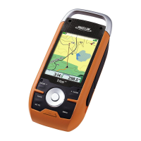
Lists key features like ease-of-use, accuracy, compass, barometer, maps, and SD expansion.
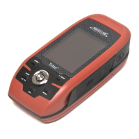
Identifies buttons, SD slot, and general user interface elements.
Covers physical characteristics, performance metrics like accuracy, and power source.
Steps for powering on/off, setting backlight, and configuring time zone.
Changing display language and configuring sleep mode/backlight timer.
Overview of the Main Menu (Go To, Create, View) and accessing it.
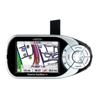
Overview of the six navigation screens and Satellite Status screen.
Guides on changing displayed navigation information on specific screens.
Tips to conserve battery, like adjusting backlight and power-off timers.
Details map display, cursors, scale adjustment, and menu access.
How to open and use option menus for Map, Compass, and Speedometer screens.
Displays current position, speed, odometer, and trip odometer.
Steps to change the data fields displayed on the Large Data screen.
Displays heading, bearing, sun, moon, and customizable data.
Steps to calibrate the electronic compass and set true north.
Graphical display of satellites and signal strength for GPS tracking.
Running tests for audio, video, keypad, or touch screen functionality.
Explains fields like latitude, longitude, heading, bearing, distance, and time.
Covers character entry, cursor movement, shift, accept, and cancel functions.
Using the calendar display for dates and noting text input limitations.
Adjusting navigation units, north reference, map datum, volume, and brightness.
Checking memory usage, clearing memory, and restoring factory settings.
Configuring PC or power source connections.
Viewing software version and copyright details.
Entering owner information for personalization.
Steps to activate and customize profiles for Hiking, Marine, Geocaching.
Settings for display, map, navigation, and alerts within profiles.
Explanation of the Waypoint Detail screen and its pages (Info, Media, Options).
Overview of waypoint creation process and naming conventions.
Steps to save the current position as a waypoint via Map screen or menu.
How to create a waypoint by selecting a location on the map with the pan cursor.
Steps to create waypoints by selecting map points or entering custom coordinates.
Entering custom latitude, longitude, elevation, and other information.
How to search, sort, and view details of saved waypoints.
How to modify the data of an existing saved waypoint.
Steps to remove saved waypoints from memory.
How to create an exact copy of a saved waypoint.
Steps to create new geocache waypoints or input existing ones.
How to modify or remove saved geocache waypoints.
How to create a copy of a saved geocache waypoint.
Explains the simplest route type, a single destination, and its creation.
Steps to create Go To routes using the pan cursor or saved waypoints.
How to create a Go To route to a preloaded place waypoint.
Steps to create routes to geocache waypoints and multi-destination routes.
Steps to start navigating a saved multileg route.
How to delete, copy, and view vertical profiles of routes.
Steps to stop and cancel an active route.
How to save recorded track data as a trail for later use and activate it.
Steps to remove saved trails from memory.
How to create copies of trails and reverse their direction.
How to hide/show trails, activate backtrack routes, and erase track data.
How to find preloaded place waypoints using the base or detailed maps.
How to enable or disable proximity alerts for place waypoints.
Accessing prediction and astronomical data for selected place waypoints.
Steps to view images stored on the SD card.