Do you have a question about the Magellan MAESTRO 3100 and is the answer not in the manual?
Guides through initial setup steps and positioning for optimal satellite signal reception.
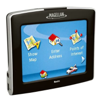
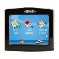
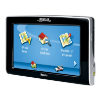
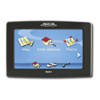
Explores options like viewing maps, creating routes to addresses/POIs, and accessing home/roadside assistance.
Covers map elements, satellite signal status, and tips to improve signal reception.
Allows adjustment of device volume and screen brightness, including battery-saving options.
Covers creating trips, entering addresses, and routing to Points of Interest (POIs).
Provides critical safety instructions for charging the device and handling the battery.
Illustrates and labels the device's front, side ports, and back view.
Guides on selecting a location, cleaning the surface, and attaching the mount.
Provides recommendations for device security and instructions for connecting power.
Details powering the device on/off and configuring automatic shutdown based on inactivity.
Explains how to adjust the device's audio volume directly from the main Map screen interface.
Details how to adjust the device's volume through the User Options menu.
Guides users on how to access and adjust the screen brightness settings.
Explains how to navigate to the Main Menu from different screens.
Covers accessing the map, entering addresses, searching POIs, and home/roadside assistance.
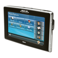
Explores trip planning, exit POIs, user options, home access, and roadside assistance features.
Illustrates keypad layouts and explains special key functions for data entry.
Offers tips for data entry and describes selecting items from displayed lists.
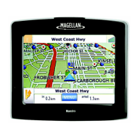
Displays the device's position on the map with time and speed information.
Explains how to access the map screen and switch between 2D/3D modes.
Details map interaction like panning and saving locations from the map view.
Describes creating a route to a location selected by panning on the map.
Covers accessing current location data and saving it to the address book.
Displays upcoming maneuvers and allows excluding specific ones from the route.
Shows a graphical representation of GPS satellite signal strength.
Explains how to adjust the map's zoom level to suit user preference.
Describes how to adjust the volume directly from the Map screen.
Guides on creating, routing to, and changing the home address.
Explains how to find and manage the home address within the device's address book.
Covers initial city selection and creating routes to new addresses.
Covers accessing the menu, routing to previous destinations, and saving them.
Details saving previous destinations to the address book and deleting them.
Guides users on how to open and view their saved address book entries.
Covers routing to and editing addresses stored in the address book.
Explains deleting addresses from the book and accessing favorites.
Covers routing, editing, deleting favorites, and creating new entries by map selection.
Explains creating new entries by typing an address or selecting a Point of Interest (POI).
Describes creating new entries using street intersections.
Provides steps to create a route by specifying two intersecting streets.
Explains POI organization and how to route by selecting categories.
Details searching for and routing to POIs by typing their names.
Covers map display during routing, split-screen alerts, and the maneuver list.
Explains arrival notification, types of routes, and selecting route methods.
Covers routing to POIs near exits, cancelling routes, and detouring.
Details how to change the route calculation method while on or off an active route.
Step-by-step guide to creating a new trip with a name and destinations.
Guides users on how to begin navigating a previously created trip.
Explains how to modify existing trips and remove saved trips from the device.
Guides users on how to change the name of a saved trip.
Details how to navigate to POIs located near freeway exits.
Guides users to system settings and explains how to check battery status.
Covers adjusting device volume and screen brightness via User Options.
Covers display brightness, auto-power off, language selection, and time zone settings.
Covers units of measure, contact details, product info, and performing diagnostics.
Guides users to the trip computer for recording and reviewing trip data.
Allows customization of which Points of Interest (POIs) are visible on the map display.
Covers global address deletion and switching between 3D/2D map modes.
Allows setting map orientation (heading/north up) and configuring split-screen display.
Enables or disables the automatic switching of map colors for nighttime viewing.
Configures automatic detour settings to navigate around traffic issues.
Explains how to use the simulator mode for practicing navigation without actual driving.
Covers selecting alert tones and viewing detailed satellite information.
Guides on manually setting the GPS position for quicker signal acquisition.
Details backing up and restoring address book and other data to an SD/MMC card.
Displays details about the installed map data, including version and build date.
Details warranty coverage, conditions, and the exclusive remedy for product defects.
Explains the steps purchasers must take to obtain warranty service and support.
Disclaims implied warranties and clarifies legal limitations on warranty coverage.
Lists items and conditions not covered by the Magellan product warranty.
Excludes consequential damages and states the warranty is the complete agreement.
Specifies governing law and clarifies consumer rights under the warranty.
| Resolution | 320 x 240 pixels |
|---|---|
| Battery Life | Up to 3 hours |
| Weight | 5.6 ounces |
| Touchscreen | Yes |
| GPS | Yes |
| Voice Guidance | Yes |
| Bluetooth | No |
| Text-to-Speech | No |
| POI Database | Yes |
| SD Card Slot | Yes |
| Maps Included | USA, Canada, Puerto Rico |
| Display Size | 3.5 inch |
| Screen Type | TFT LCD |