EasyManua.ls Logo

Memory-map Adventurer 2800 User Manual

Memory-map Adventurer 2800
12 pages
To Next Page IconTo Next Page
Page #1 background imageLoading...
Page #1 background image
1
User Guide
Introduction
Welcome to the Adventurer 2800 - ready to use straight from the box with selected pre-loaded
Ordnance Survey 1:50,000 Landranger maps of Britain’s National Parks. Existing Memory-Map
mapping on your PC can also be easily uploaded to the device as well as routes, tracks and marks.
The Adventurer 2800
Menu
Expands the icon menu to
provide more options
GPS Lock
Shows your current position
on screen and automatically
scrolls the map as you move
Goto Mark
Shows a list of the nearest marks
and waypoints to your location.
Tap on one to begin navigation
Location Heading
Displays the heading to
take to reach the next
mark or waypoint
Navigation Window
Displays navigation
information to reach the
next mark or waypoint
Position Icon
Your current location. The
arrow indicates the direction
you are heading in
Zoom In
Tap to zoom into the map. If
available, more detailed
maps will be displayed as
you zoom in
Zoom Out
Tap to zoom out from the
map. If available, less detailed
maps will be displayed as you
zoom out
Battery Light
Glows blue to indicates the battery
is charging. The light will go out
when the battery is charged

Other manuals for Memory-map Adventurer 2800

Question and Answer IconNeed help?

Do you have a question about the Memory-map Adventurer 2800 and is the answer not in the manual?

Memory-map Adventurer 2800 Specifications

General IconGeneral
BrandMemory-map
ModelAdventurer 2800
CategoryGPS
LanguageEnglish

Summary

Introduction to Adventurer 2800

Adventurer 2800 Device Overview

GPS Lock

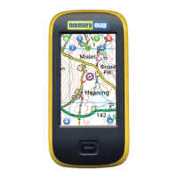
Shows current position and automatically scrolls the map as you move.

Goto Mark

Shows nearest marks/waypoints and initiates navigation.

Menu Button

Expands the icon menu to provide more options.

Position Icon

Indicates current location and direction of travel on the map.

Location Heading

Displays the heading needed to reach the next mark or waypoint.

Navigation Window

Provides navigation information for the next mark or waypoint.

Zoom Controls

Allows zooming into or out of the map display.

Battery Light Indicator

Glows blue when charging, goes out when fully charged.

Adventurer 2800 Interface Features

Overlay and Settings Menu

Manage overlays and change advanced settings on the device.

Menu Navigation

Returns to the original icon menu from other screens.

Info Button

Displays the current status of the GPS receiver.

Quick Map Change

Allows quick switching to different scale maps at the current location.

Exit Memory-Map

Saves all overlays and exits the Memory-Map program.

Position Read-out

Displays positional coordinates when any point on the screen is selected.

Drop Mark Function

Places a mark on the screen at the exact location tapped.

Getting Started

Power and Battery Switches

Controls for turning on/off and conserving battery power.

Device Charging and Power Management

Charging the Device

Instructions for charging the Adventurer 2800's battery.

Optimizing Battery Life

Tips for extending battery life, like adjusting backlight timeout.

Using Memory-Map Software

Launching Memory-Map

How to start the Memory-Map application on the device.

Acquiring GPS Signal

Process of obtaining a GPS lock and displaying current location.

Accessing GPS Information

How to view signal strength and positional data via menus.

PC Connectivity and Data Transfer

PC Connectivity Overview

Explains how the device appears as a removable drive to a PC.

Transferring Data to Device

Steps to transfer routes, tracks, and marks from PC to Adventurer 2800.

Transferring Data from Device

Steps to save routes, tracks, and marks from Adventurer 2800 to PC.

Sending Maps to Adventurer 2800

Sending Memory-Map V5 Maps

Instructions for sending Memory-Map V5 and Digital Map Shop maps.

Sending Non-Digital Map Shop Maps

Methods for sending V5 maps, including whole map transfer (under 400MB).

Sending Visible Map Portion

Method to send a specific portion of a map based on screen view.

Sending Enclosed Area Map

Method to send map area defined by a drawn route.

Sending Encrypted or Digital Maps

Process for sending and activating Digital Map Shop and encrypted maps.

Viewing Digital Map Shop Maps

Opening and Viewing Maps

Steps to open and display Digital Map Shop maps on the GPS.

Managing Routes, Tracks, and Marks

Deleting and Editing Overlays

How to delete, edit, and view marks, routes, and tracks via menus.

Setting Up a New SD Card

Copying Original SD Card Files

Instructions for copying files from the original SD card to a new one.

Licensing the New SD Card

Steps to license GPS features for a new SD card on the PC.

Related product manuals