Do you have a question about the Seeed Grove GPS Air530 and is the answer not in the manual?
Demonstrates how to use the Grove-GPS module with the Arduino platform.
Provides sample Arduino code for reading GPS data via software serial.
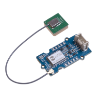
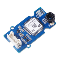
The Grove - GPS (Air530) is a high-performance, highly integrated multi-mode satellite positioning and navigation module designed to provide accurate location data for a wide range of applications. This module is particularly useful in urban environments or areas with limited satellite visibility, where traditional GPS modules might struggle to acquire a strong signal from a single or a few satellite systems. Its advanced capabilities make it a versatile choice for projects requiring reliable and precise positioning.
At its core, the Grove - GPS (Air530) functions as a Global Navigation Satellite System (GNSS) receiver. It is capable of receiving signals from multiple satellite constellations, including GPS (Global Positioning System), BeiDou, Glonass, Galileo, QZSS (Quasi-Zenith Satellite System), and SBAS (Satellite-Based Augmentation System). This multi-mode support is a key differentiator, allowing the module to leverage a broader array of satellites for position calculation, thereby enhancing accuracy, availability, and reliability, especially in challenging environments.
The module processes these satellite signals to determine its precise geographical coordinates (latitude, longitude, and altitude), as well as velocity and time. It outputs this data in standard NMEA (National Marine Electronics Association) sentences, which are widely understood and easily parsed by microcontrollers and other computing devices. This standardized output ensures broad compatibility with existing software and development tools.
The integration of the Air530 module into the Grove system simplifies its use with various development boards, such as Arduino and Raspberry Pi. The Grove connector provides a plug-and-play interface, eliminating the need for complex wiring and breadboarding, which accelerates prototyping and development cycles. The module typically communicates via a serial interface (UART), making it straightforward to connect to a microcontroller's serial pins.
Beyond basic positioning, the module's multi-GNSS capabilities contribute to faster time-to-first-fix (TTFF), meaning it can acquire a position lock more quickly, especially during cold starts. This is crucial for applications where rapid location updates are essential. The module's ability to utilize multiple constellations simultaneously also improves positional accuracy by mitigating the effects of signal obstructions and atmospheric interference.
The Grove - GPS (Air530) is designed with several features that make it highly adaptable and user-friendly across various applications:
Multi-GNSS Support: The most prominent feature is its compatibility with GPS, BeiDou, Glonass, Galileo, QZSS, and SBAS. This extensive support ensures robust positioning performance even in areas where signals from a single constellation might be weak or unavailable. For instance, in dense urban canyons or mountainous regions, having access to multiple satellite systems significantly improves the chances of obtaining a reliable fix. This is particularly beneficial for car navigation systems, smart wearables, and drones, where continuous and accurate positioning is critical.
Ease of Integration (Grove System): As part of the Grove ecosystem, the module offers a simplified connection experience. The standardized Grove connector allows for quick and error-free hookup to Grove-compatible base shields or directly to microcontrollers with appropriate wiring. This "plug-and-play" nature reduces the complexity of hardware setup, making it accessible for hobbyists and professional developers alike. The provided software libraries and code examples, primarily for the Arduino platform, further streamline the integration process, allowing users to get started with data acquisition rapidly.
Compact Size and Low Power Consumption: The module's compact form factor makes it suitable for integration into space-constrained devices. This is particularly important for portable applications like smart wearables, where device size and weight are critical considerations. Furthermore, its low power consumption ensures that it can operate efficiently on battery-powered devices, extending their operational life. This feature is vital for drones and other remote sensing applications that rely on limited power sources.
Fast Time-to-First-Fix (TTFF): The module boasts a quick warm start time and a reasonable cold boot time, enabling it to acquire a position fix rapidly. A fast TTFF is crucial for applications that require immediate location data upon power-up, such as emergency tracking devices or quick-deployment drones. The multi-GNSS support contributes to this speed by increasing the probability of quickly locking onto a sufficient number of satellites.
NMEA Data Output: The module outputs positioning data in the universally recognized NMEA 0183 format. This text-based protocol is easy to parse and integrate into various software applications, from simple serial monitors to complex mapping and navigation systems. The ability to stream NMEA data directly allows developers to access raw positioning information for custom processing or display.
Compatibility with U-center Software: For Windows users, the module is compatible with u-center software from u-blox. This powerful tool provides a graphical interface for configuring the GPS module, visualizing satellite data, and analyzing positioning performance. It allows users to monitor NMEA data streams, check satellite visibility, and even log data for post-processing. This compatibility enhances the debugging and testing capabilities for developers.
Google Earth KML Export: The u-center software also facilitates the export of captured GPS data into Google Earth KML (Keyhole Markup Language) files. This feature allows users to visualize their recorded tracks and waypoints directly on Google Earth, providing a clear and intuitive way to review movement paths and geographical information. This is particularly useful for mapping, surveying, and tracking applications.
GPSVisualizer Integration: For more flexible data visualization, the module's generated .ubx files (raw data logs) can be uploaded to online tools like GPSVisualizer.com. This platform converts the raw data into various formats, including KML, and allows for advanced mapping and analysis, showing the recorded tracks and points on different map layers. This provides an alternative and powerful way to interpret and present the collected GPS data.
Robust Performance in Challenging Environments: The primary motivation behind the Air530's multi-mode capabilities is to overcome the limitations of single-constellation GPS in difficult conditions. Whether it's signal blockage from tall buildings in urban areas, dense foliage, or adverse weather, the module's ability to draw from multiple satellite systems significantly improves its chances of maintaining a stable and accurate position lock. This makes it a reliable choice for applications that operate in diverse and unpredictable environments.
While the Grove - GPS (Air530) is largely a "set and forget" component once integrated, there are a few aspects related to its maintenance and optimal performance:
Software Updates and Libraries: Keeping the associated software libraries and firmware (if applicable) up-to-date is good practice. Seeed Studio, as the provider of the Grove system, often releases updates or improvements to their Arduino libraries. Regularly checking the official wiki page or GitHub repository for the latest versions ensures access to bug fixes, performance enhancements, and new features.
Environmental Considerations: Although the module is designed for robust performance, protecting it from extreme environmental conditions (e.g., direct water exposure, excessive dust, extreme temperatures beyond its operating range) will ensure its longevity. For outdoor applications, housing the module in a suitable enclosure is recommended.
Antenna Placement: The performance of any GPS module is heavily dependent on its antenna. Ensuring the antenna has a clear, unobstructed view of the sky is paramount for optimal signal reception. For permanent installations, careful consideration of antenna placement to minimize signal blockage from surrounding structures or the device itself is a key maintenance aspect. Regular checks to ensure the antenna connection is secure and the antenna itself is undamaged can prevent performance degradation.
Power Supply Stability: Providing a stable and clean power supply (within the specified voltage range) is essential for the module's reliable operation. Fluctuations or noise in the power supply can affect the module's ability to acquire and maintain a satellite fix.
Troubleshooting Resources: In case of issues, the Seeed Studio wiki provides troubleshooting guides and a forum for community support. Understanding how to interpret NMEA data and using tools like u-center can aid in diagnosing problems related to signal reception or data output. The availability of a selection guide for GPS modules also helps users choose the right module for their specific needs, preventing potential issues arising from using an unsuitable device.
In summary, the Grove - GPS (Air530) stands out as a highly capable and user-friendly GNSS module, offering superior positioning performance through its multi-constellation support. Its integration into the Grove ecosystem, combined with its compact size and low power consumption, makes it an excellent choice for a wide array of applications, from personal tracking to advanced drone navigation, especially where reliability in challenging environments is a priority.
| Type | GPS Module |
|---|---|
| Chip | Air530 |
| Frequency | L1, 1575.42MHz |
| Accuracy | 2.5m CEP |
| Update Rate | 10 Hz |
| Interface | UART |
| Time to First Fix | Hot start: 1s |
| Operating Voltage | 3.3V |
| Baud Rate | 9600 |
| Antenna | Built-in |
| Sensitivity | -165dBm |