Do you have a question about the SELFSAT HH90 and is the answer not in the manual?
Details on communication protocol, weight, dimensions, rotation, power, consumption, temperature, humidity, and limits.
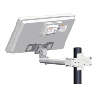
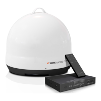
List of parts included for the rotor assembly, with their quantities.
List of parts included for the antenna assembly, with their quantities.
Instructions for connecting coaxial cables and F-connectors between receiver, rotor, and antenna.
Details on coaxial cable diameter and resistance based on length for optimal performance.
Steps to configure the satellite receiver for USALS mode using latitude and longitude.
Key safety guidelines including professional installation, mounting orientation, screw usage, wind resistance, and reachability.
Warnings against upside-down mounting, using unapproved power sources, exceeding load limits, and improper purposes.
Information on potential receiver interference and electric shock risks, advising receiver disconnection.
Details on the 36-month warranty, covering production defects but excluding user-induced damages or unauthorized repairs.
Contact details for local dealers and manufacturer support for technical assistance and information.
Map of Norway, Sweden, Finland, Denmark, and Baltic Republics showing latitude and dish elevation.
Map of the United Kingdom and Eire showing latitude and dish elevation for satellite alignment.
Map of Northern Germany and the Netherlands indicating antenna elevation based on location.
Map of Southern Germany, Austria, Switzerland, and Slovenia showing antenna elevation zones.
Map of France and Belgium detailing antenna elevation angles for satellite dish alignment.
Map of Spain and Portugal displaying antenna elevation values for various locations.
Map of Northern Italy showing antenna elevation angles for satellite dish positioning.
Map of Southern Italy indicating antenna elevation values across different regions.
Map of Morocco, Algeria, and Tunisia showing antenna elevation for satellite alignment.
| Frequency Range | 10.7 - 12.75 GHz |
|---|---|
| Operating Temperature | -30°C to +60°C |
| Type | Satellite Antenna |
| Polarization | Linear |
| Mounting/Mount Type | Pole Mount |
| Compatibility | DVB-S, DVB-S2 |