EasyManuals Logo

TomTom START User Manual

TomTom START
105 pages
To Next Page IconTo Next Page
To Previous Page IconTo Previous Page
Page #62 background imageLoading...
Page #62 background image
62
Use a tool such as Tyre Pro to view your track file.
Export to a memory card or directly to your computer, then use your computer to view the file
using software such as Google Earth.
Note: While viewing your recording, you may notice that the recorded GPS locations do not
always correspond with the roads. This can happen for several reasons. Firstly, your device
tries to keep the files small and this can cause a slight loss of data precision. Secondly, your
device records the actual data from the GPS chip for an accurate representation of where
you’ve been, rather than what you see on your screen. Thirdly, the software with which you
view the recording may have the maps misaligned.
Share the file with friends by exporting it.
Note: Tracks can be imported and exported.
ITN files (TomTom's own Itinerary file format)
An ITN file contains less detail than a GPX file. An ITN file can contain a maximum of 255 locations
which is enough to recreate a route accurately. ITN files become routes after import.
Using ITN files
There are several things you can do with your ITN file:
You can import an ITN file onto your TomTom START so you can travel that same route again
and get navigation instructions.
Use tools such as Tyre Pro to view your route.
Note: Routes can be imported but cannot exported.
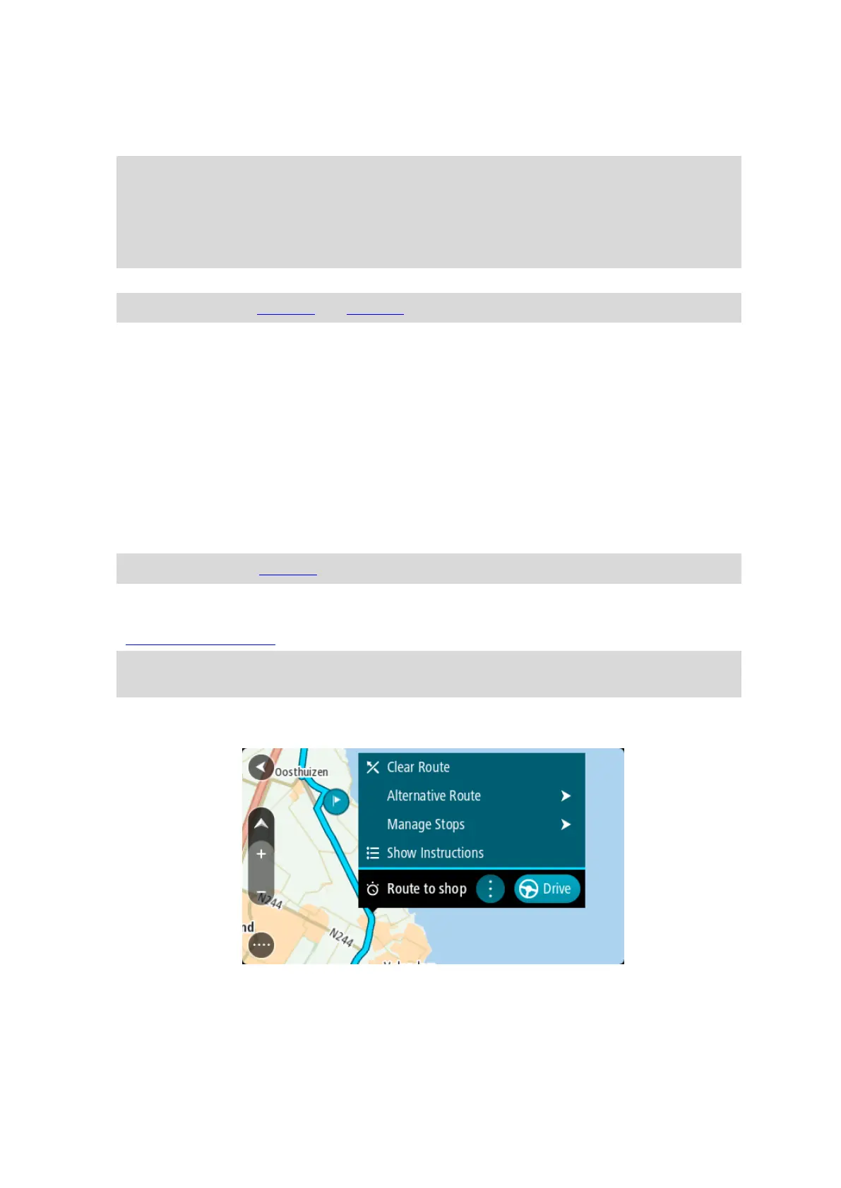
Saving a route
1. Plan a route in advance.
Tip: If you cannot see your planned route on the map view, select the back button to show
your route.
2. Select the route.
3. Select the pop-up menu button to open the menu.
4. Select Manage Route.
5. Select Add to My Routes.
The name of the route is shown in the edit screen.
6. Edit the name of the route so that you can easily recognise it.

Table of Contents

Other manuals for TomTom START

Questions and Answers:

Question and Answer IconNeed help?

Do you have a question about the TomTom START and is the answer not in the manual?

TomTom START Specifications

General IconGeneral
AutoYes
Marine (chartplotters, sounders)No
Form factorHandheld/Fixed
Product colorBlack
Display diagonal3.5 \
Display resolution320 x 240 pixels
Native aspect ratio4:3
Power source typeBattery, Cigar lighter
Battery life (max)2 h
Battery technology-
Spoken street namesKeep your eyes on the road while your GPS announces turn-by-turn directions, including street and place names.
Storage media typeFlash
Compatible memory cardsNot supported
Internal storage capacity2 GB
Cables includedUSB
Map coverageWestern Europe
Plug & GoYour device couldn't be simpler to use - just plug in and tap the touch screen. You will be on your way quickly with preloaded maps and our intuitive user interface.
QuickGPSfixQuickGPSfix speeds up the time it takes to fix your GPS position to help you get on the road more quickly.
Speeding alertAlerts you when you’re speeding, even if you're not in navigation mode.
Integrated mountingA convenient foldaway mount that’s integrated with your device, so it’s always there when you need it. It attaches easily to your windscreen. And using the optional mounting disk, you can turn it upside down and position it on your dashboard too, where th
IQ Routes technologyDespite posted speed limits, traffic traveling along a road at 8 a.m. moves at a different pace than it does at 2 p.m. Actual traffic speed is affected by rush hour, traffic light changes, pedestrian traffic, day of the week, and more. Only TomTom offers
Latest map guaranteeWhen you start using your TomTom, if a newer map release is available you can download one complimentary update to your map within 30 days from the time you first start using your TomTom device. Latest Map Guarantee is available via TomTom HOME.
Frequent destinationsYou can choose icons for your most frequent destinations and add your own text. This makes your navigation experience truly your own with even easier and quicker navigation to the places you go most often.
Advanced lane guidanceTomTom provides extra clarity when navigating difficult junctions by showing you which lane to take, so you won’t miss your turn or have to make dangerous lane crossings. Photorealistic images and a pulsing green arrow indicate exactly which lane to use.\\
Rich Points of InterestYour pre-installed map has Points of Interest from gas stations to hotels, so you are sure to find what you want. You can now also download additional POIs from TomTom HOME.
Weight and Dimensions IconWeight and Dimensions
Depth20 mm
Width94 mm
Height81 mm
Weight125 g

Related product manuals