Do you have a question about the VDO MAP 11csE Plus GPS and is the answer not in the manual?
Explains the manual's purpose, conventions, and expert functions.
Outlines the manual's structure and how to get help.
Critical safety notices and handling precautions for the chart plotter.
Step-by-step guide for safely cleaning the chart plotter's display.
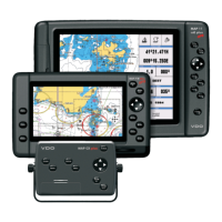
Explains the basic keys and their functions on the chart plotter.
Details the features of the C-MAP MAX electronic chart system.
Explains how GPS works, including position fixing accuracy.
Covers powering on/off, backlight, and contrast adjustments.
Setting user interface language, chart language, and using data cards.
Managing display modes, navigation to destinations, EBL/VRM, and MOB.
Creating, editing, and managing waypoints, marks, and routes.
Using Goto, Track, and Info functions for navigation and data display.
Accessing port/tide data and using the find function for locations.
Setting up various alarms for navigation and safety.
Backing up and managing data using a User C-CARD.
Configuring map layout, zoom types, fonts, and perspective view.
Customizing display modes, marine features, depth, land, and chart settings.
Adjusting general configurations, navigation settings, and coordinate systems.
Configuring the Automatic Identification System (AIS) for target display.
Setting up GPS, Fish Finder, Autopilot, NMEA, and other I/O connections.
Explains sharing cartographic data between chart plotters via serial connection.
Details data transfer modes (Master/Slave) and graphical representation.
Connecting and setting up the MOBILARM system for crew monitoring.
Managing PTX transponder data, including GoTo and list functions.
Explains echogram elements, display modes, and zoom functions.
Configuring preset modes, gain, range, depth, and display settings.
Performing system tests, RAM checks, and diagnosing issues.
Verifying serial port parameters and C-CARD functionality.
Definitions of key terms used in the manual and chart plotter.
Details features, technical specs, C-CARD handling, and installation.
Provides external wiring and typical connection diagrams for the models.
Details features, technical specs, C-CARD handling, and installation.
Provides external wiring and typical connection diagrams for the model.
Details features, technical specs, C-CARD handling, and installation.
Provides external wiring and typical connection diagrams.
Details features, technical specs, C-CARD handling, and installation.
Provides controller dimensions, external wiring, and connection diagrams.
Details CAN interface data input and SAE J1939 specifications.
Guides on choosing location and installing the GPS antenna.
Provides dimensional information for the GPS antenna.
| Resolution | 480 x 272 pixels |
|---|---|
| GPS | Yes |
| Waterproof | Yes |
| Waterproof Rating | IPX7 |
| Display | Color LCD |
| Memory | Internal memory |
| Expansion Slot | SD Card |
| Power Supply | 12 VDC |