EasyManua.ls Logo

VDO MAP 7w Plus GPS User Manual

VDO MAP 7w Plus GPS
120 pages
To Next Page IconTo Next Page
Page #1 background imageLoading...
Page #1 background image
VDO Chart Plotters
www.vdo-marine.com
_ MAP 7 V GPS
_ MAP 7 cs GPS
_ MAP 7 W/Wi/Plus GPS
_ MAP 11 csE/Plus GPS
VDO Marine
Office address: Kienzle Automotive GmbH
Alexanderstr.37-39 45472 Mülheim
Phone: +49 (0) 208/ 4950 5 177
Fax: +49 (0) 208/ 4950 5 353
E-mail: marine@vdo-marine.com
Part-Nr. NEW KI-0301-001-1207E I
Kienzle Automotive GmbH I Printed in Italy
© 2007 MAALLVDODX
We reserve the right to make changes in ava bility as well as
technical changes without prior notice.
ila

Table of Contents

Question and Answer IconNeed help?

Do you have a question about the VDO MAP 7w Plus GPS and is the answer not in the manual?

VDO MAP 7w Plus GPS Specifications

General IconGeneral
Resolution800 x 480 pixels
GPSYes
Screen Size7 inches
Voltage12/24 V
MountingFlush or bracket

Summary

Important Information and Safety

Warnings and Cautions

Highlights critical warnings and cautions for safe operation and maintenance.

1. Overview of Chart Plotter

Understanding GPS Navigation

Describes how the GPS system works and its role in determining position.

2. Getting Started with Your Chart Plotter

Powering On and Off

Instructions for switching the chart plotter on and off correctly.

Navigation to a Destination

Steps for setting a destination and initiating navigation.

Man Overboard (MOB) Function

Procedure to activate and use the Man Overboard function.

3. Operations and Functions

User Points: Marks and Waypoints

Creating, editing, and managing user-defined points on the chart.

Routes Management

Creating, editing, selecting, and following navigation routes.

Go To Function

How to set a destination and start navigating to it.

Alarms Configuration

Setting up and managing various audible and visual alarms.

4. User Setting Up Your Chart Plotter

Advanced Settings Menu

Accessing advanced settings for setup, navigation, and compass.

Input and Output Configuration

Setting up serial ports, GPS, NMEA, and other input/output connections.

5. C-LINK System

C-LINK System Overview

Explains the C-LINK feature for sharing cartographic data between plotters.

6. MOBILARM System

7. Fish Finder Operation

Setting Up Internal Fish Finder

Procedure to enable the internal fish finder transmission.

8. Maintenance and Troubleshooting

System Test Procedures

Instructions for performing system tests to diagnose problems.
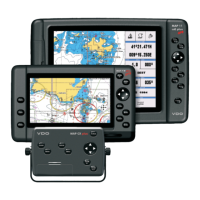
Related product manuals