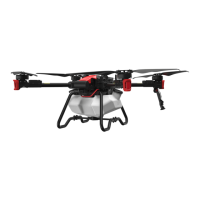
The XMISSION Multi-functional Unmanned Aerial System is a sophisticated drone designed for various applications, particularly in agriculture, as indicated by the "MAKE AGRICULTURE SMARTER" tagline. This quick start guide provides an overview of its structure, activation process, remote controller usage, battery management, and flight safety.
Function Description:
The XMISSION is a multi-functional unmanned aerial system (UAS) capable of performing tasks that likely involve aerial mapping, surveying, and potentially other agricultural applications given the optional multispectral and mapping cameras. It operates with a remote controller and a dedicated mobile application, "XGEOMATICS," which supports various control modes. The system is designed for both manual and automatic flight operations.
Important Technical Specifications:
Aircraft: XMISSION
- Weight (including propeller and battery): 2.25kg
- Wheel base: 492mm
- Maximum take-off altitude: 6,000m
- Maximum ascending speed: 4m/s (manual flight), 6m/s (automatic flight)
- Maximum descending speed: 3m/s
- Maximum horizontal flight speed: 57.6km/h (flight mode)
- Maximum tilt angle: 35°
- Maximum rotation angular velocity: 150°/s
- Flight duration: up to 35 minutes
- Operating environment temperature: -20°C to 40°C
- Operating frequency:
- 2.400 GHz to 2.483 GHz (Europe, Japan, South Korea)
- 5.725 GHz to 5.850 GHz (China, the United States)
- Equivalent Isotropically Radiated Power (EIRP):
- 2.4GHz: FCC: ≤28 dBm, CE: ≤19 dBm, SRRC: ≤19 dBm, MIC: ≤19 dBm
- 5.8 GHz: FCC: ≤31 dBm, CE: ≤14 dBm, SRRC: ≤27 dBm
- GNSS:
- Single frequency high sensitivity GNSS
- GPS+BeiDou+Galileo (Asia), GPS+GLONASS+Galileo (other regions)
- Multi-frequency, multi-system and high-precision RTK/GNSS
- Used frequency point: GPS: L1/L2, GLONASS: L1/L2, BeiDou: B1/B2, Galileo*: E1/E5
- Initial positioning duration: <50s
- Positioning precision: 1.5 cm + 1 ppm (RMS) (vertical), 1 cm + 1 ppm (RMS) (horizontal)
- 1 ppm means that error of the aircraft increases by 1 m for every 1 km it moves.
- Terrain tracing:
- Above 100m: hypsographic map terrain tracing, precision ±10m
- Below 100m: radar terrain tracing, precision ±0.5m
Camera:
- Image sensor: 1-inch CMOS; 20 million effective pixels (20.48 million total pixels)
- Lens: FOV 75°/10.6mm/29mm (35mm equivalent format)/diaphragm f/2.8 - f/11/with automatic focusing (focusing distance 1m - ∞)
- ISO range:
- Video: 100-3200 (automatic), 100-6400 (manual)
- Photo: 100-3200 (automatic), 100-12800 (manual)
- Mechanical shutter: 8-1/2000 s
- Electronic shutter: 8-1/8000 s
- Maximum photo resolution: 4864×3648 (4:3), 5472x3648(3:2)
- Image format: JPEG
- Supported file system: FAT32 (≤32 GB), exFAT (> 32 GB)
- Internal Storage: emmc 5.1 32G
- Type of memory card supported: microSD card (up to 128G) with writing speed ≥15 MB/s and transmission speed of Class 10 or above or up to UHS-1 rating
Smart flight battery:
- Model: B6130
- Capacity: 6,000-mAh
- Battery type: LiPo 6s
- Energy: 130Wh
- Overall weight of battery: 720g
Power adapter:
- Model: C26200
- Voltage: 26V
- Rated power: 200W
Usage Features:
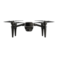
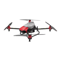
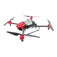
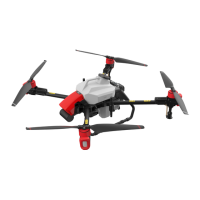
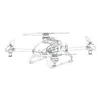
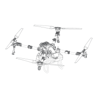
- Aircraft Structural Components: The drone features propellers, visual-based obstacle avoidance radar, motors, landing skid buckles, flight indicator lights, expansion interfaces, arm buckles, arms, landing skids, 2.4/5.8GHz antennas, 4G antennas, battery buckles, terrain tracing radar, SD card/data interface, camera, navigation lights, visual positioning, and a battery.
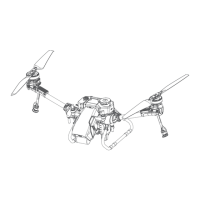
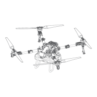
- Assembly: The aircraft requires simple assembly steps: expanding the frame arms until they click into place, expanding the landing skid until it clicks, mounting the camera by inserting it into the slot and rotating a buckle, and inserting the battery into its compartment from the back.
- Activation: First-time use requires activation via the "XAG member" applet on WeChat. This involves registering an account, adding the device by scanning a QR code or manually inputting the serial number, and selecting an activation mode (with or without full-coverage service).
- Remote Controller (ACB1 CommBack):
- Download APP: Users need to download the "XGEOMATICS" APP by scanning a QR code from XAG Academy.
- Turn On: Long press the Power Button twice (2 seconds each time) to turn on the remote controller.
- Device Connection: Connect the phone to the remote controller via a data cable, open the "XGEOMATICS" APP, and wait for connection. View and record the hot spot name and password from the controller (default: XAG123, 20070401). Set the phone's hot spot name and password to match the controller, then turn on the phone's hot spot. Disconnect the data cable, and wait for the WIFI connection icon on the APP to turn green, indicating a successful wireless connection.
- Battery Management:
- ON/OFF: To turn on, press and hold the power button twice (1 second each time) until a "beep" is heard and all indicator lights turn on. To turn off, follow the same procedure.
- Checking Battery Level: Short press the power button once when off to display the current level. When on, the indicator lights continuously display the level.
- Battery Preheating: Long press the power button for 5 seconds until a "beep" is heard to start preheating. The battery will turn off automatically after heating. No device should be connected during preheating.
- Charging: During charging, indicator lights in the undercharged area flash in series, and fully-charged lights are solid. A buzzer beeps for 30 seconds upon completion, and lights flash for 2 minutes before the battery turns off.
- Flight Indicator: The aircraft's flight indicator lights (red, green, purple, blue, white) provide visual feedback on its status, including GPS signal strength, GPS mode, flight controller initiation, abnormal parameters, power system issues, GPS errors, sensor issues, IMU errors, and low voltage alarms.
- Flight Safety: Emphasizes flying in open, familiar areas, avoiding obstacles and crowds. Users should not operate when fatigued or under influence, keep away from heat sources, and avoid operating alone during initial learning. Pre-flight checks are crucial, and propellers should not be installed until after these checks. Loose clothing should be avoided to prevent entanglement.
- Disclaimer: Highlights the importance of reading the document for safe use and understanding rights. States the product is not a toy and requires an operator certificate. Users are responsible for legitimate use and compliance with laws. XAG is not liable for losses due to non-compliance or inability to use the product.
- Real-name Registration (China ONLY): Requires owners of civil UAVs in China to register in real name and attach registration marks as per Civil Aviation Administration of China (CAAC) regulations.
Maintenance Features:
- Battery Status Indicators: The battery features LED indicator lights that show its charge level (0-100%), temperature status (low or high, indicated by slow or quick red flashes), and malfunction (double red flash).
- Self-locking and Remote Locked Status: The battery can enter a "self-locking" state due to low voltage or be "remote locked," both requiring contact with customer support to unlock.
- Overheated/Low Temperature Warnings: The battery provides clear red light indications for overheating (quick flash) and low temperature (slow flash), with the latter indicating a need for pre-heating.
- Battery Malfunction: A two-light red flash indicates a battery malfunction, requiring immediate cessation of use.
- Charging Warnings: Users are warned to only charge the battery with the designated charging device to avoid consequences.
- Pre-flight Check: The guide recommends conducting a pre-flight check to ensure the device is normal and free from frequency interference. It also suggests not installing propellers during this check.