Do you have a question about the AllyNav R10 and is the answer not in the manual?
Key features include small size, high integration, accuracy, low power, IP54 rating, Bluetooth 4.0, and long battery life.
Details signal tracking, initialization times, accuracy indices for single point and RTK positioning.
Specifies data formats, electrical parameters, physical properties, and data interface details.
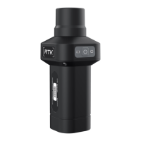
Explains connection and power indicator lights, and power button operation.
Guidance on charging interface use and safety notices for port protection.
Overview of AllyPad software, its development, features, and main parts.
Step-by-step guide to connect the R10 to AllyPad software via Bluetooth.
Details the point survey interface, data collection, and accuracy settings.
Covers attribute naming, coding, and setting antenna height for precise measurements.
Explains entering the stakeout interface and managing points for field layout.
Guidance on target setting, compass use, and navigating to stakeout points.
The R10 portable high-precision locator is a lightweight, simple, and practical GNSS RTK receiver, designed to offer a cost-effective solution for both portable and high-precision positioning needs. Its compact size and high integration allow it to incorporate a high-capacity battery, GNSS antenna, satellite positioning module, and Bluetooth, all within a single device. This design ensures ease of use and portability, making it suitable for various field applications.
One of the key usage features of the R10 is its versatility in positioning. It supports five constellations and sixteen frequencies for positioning data, including BeiDou, GPS, GLONASS, Galileo, and QZSS. This multi-constellation support ensures high accuracy and reliable positioning even in complex environments, which is crucial for demanding survey tasks. The device is built with a high-performance aluminum alloy body, providing durability and a robust feel.
The R10 is designed for flexible deployment. It can be used handheld for quick and mobile measurements or screwed directly onto an alignment bar for more stable and precise surveying. This adaptability makes it a valuable tool across a wide range of applications, from engineering and geological surveys to precision agriculture, land surveying, unmanned vehicle guidance, geographic information systems, water surveys, and aerial photogrammetry.
For connectivity, the R10 features a built-in Bluetooth 4.0 module, enabling seamless connection with Android cell phones. This allows users to leverage the AllyPad software, an engineering survey application developed by Shanghai AllyNav Technology Co., Ltd. The AllyPad software is designed with a user-friendly interface, incorporating years of surveying and mapping development experience and market feedback. It caters to the habits of a large number of industry users and aligns with Android operation styles. The software offers a humanized operation process, making it simple to use for high-precision position survey and collection, point and line setting out, road design and construction, and CAD figure setting. It also provides a convenient functional menu display and customizable design.
The AllyPad software is structured into four main parts: Projects, Device, Survey, and Tools. The Device section allows users to manage communication with the R10, including functions for Rover, Base, Static, Inspection accuracy, Device Setting, Restart Positioning, and Device Information. To connect the R10, users select the instrument manufacturer and type (R10) within the software and then initiate communication, typically via Bluetooth. The software supports various communication modes, including Bluetooth and TCP client communication, with Bluetooth being a widely supported basic mode across manufacturers. After successful connection, users can access debugging features to view communication data and send commands to investigate positioning-related issues.
The Survey section of the AllyPad software includes Point Survey and Point Stakeout functions. In Point Survey, the GNSS device output is measured and collected into a coordinate point library, subject to specified precision limits. The interface displays essential positioning information such as solution status, difference delay, HRMS and VRMS accuracy evaluation values, and the number of received satellites. Users can customize the display content, including high coordinates and base station distance. The software also features a drawing area for data visualization, with an electronic compass to aid in direction judgment. Survey attributes like naming and encoding can be input, and antenna height settings are available to ensure accurate measurement of the actual target position on the ground. The software allows users to select the correct antenna type from an antenna management system, which is particularly useful when the GNSS equipment does not output antenna information or when an external antenna is used.
The Point Stakeout function allows users to locate known points at a field site. Users can select points from the coordinate point library for stakeout. The stakeout interface is similar to the point survey interface but includes additional information such as southeast and northwest deviation values from the target. The electronic compass is integrated to show the current position relative to the target. Users can set the target direction (southeast, northwest, left, or right) and define the reference direction (host's front or a known reference point). Prompt ranges and stakeout limit differences can also be configured. The software provides visual cues, such as a small arrow, to guide users towards the target point, making it easier to navigate, especially for those who may not have a strong sense of direction. By aligning the data controller's pointing with the target point orientation, users can confidently move forward to reach the desired location.
Maintenance features for the R10 include a standard TYPE-C charging interface, which supports charging of rechargeable batteries and TYPE-C upgrades. This universal interface simplifies charging and ensures compatibility with common charging cables. The device also boasts a robust IP54 waterproof and dustproof design, providing protection against environmental elements. It is resistant to 2-meter drops, enhancing its durability in demanding field conditions. The R10 is equipped with a single button for operation and two LED indicators to provide status feedback. Users are advised to avoid placing the charging port in water or humid environments for extended periods and to cover the dust-proof silica gel when not charging to prevent damage from water and dust.
The R10 is designed for ultra-long battery life, with a built-in 4800mAh high-capacity battery that provides more than 16 hours of continuous use on a single charge, thanks to its low power consumption. This extended operational time is critical for prolonged field work without the need for frequent recharging. The total weight of the equipment is 0.55kg, making it exceptionally small and light, further contributing to its ease of transport and handling in the field. The software also supports various CORS systems, Thousand Seekers, and Six Points, and includes a free 1-year China Mobile national high-precision RTK positioning service, enhancing its utility and value for professional users.
| GNSS Support | GPS, GLONASS, Galileo, BeiDou |
|---|---|
| Data Logging | Yes |
| Type | Handheld GPS |
| Resolution | 240 x 320 pixels |
| Waypoints | 1000 |
| Tracks | 100 |
| Communication | Bluetooth |
| Display | 2.8 inch color |
| Battery | Rechargeable Li-ion |
| Memory | 8GB |
| Connectivity | USB |
| Languages | Multiple |