Do you have a question about the Cobra MC 600Ci and is the answer not in the manual?
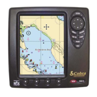
Explains the advanced computerized electronic chart system and its navigation aid capabilities.
Provides contact details and support services for product inquiries and technical assistance.
Describes how software buttons change function based on the current operation or mode.
Encompasses a wide range of functionalities like 3D mapping, GPS, alarms, and data management.
Covers power, interface, display, resolution, operating range, and water resistance.
Covers fundamental operating principles, button conventions, and menu navigation.
Instructions for powering the chartplotter on, off, and understanding auto power functionality.
Describes the first-time configuration process, including GPS setup.
Explains the purpose and available choices for each setup parameter.
How to modify the screen's brightness and contrast levels for optimal visibility.
Describes using ZOOM buttons to adjust the chart scale and detail level.
Step-by-step instructions for creating a new waypoint on the chart.
Describes how to place a mark on the chart to denote a specific point of interest.
Steps to activate the MOB function and create a MOB waypoint.
Configuring which pages are active and assigning them as shortcuts.
Covers functions related to chart display, user points, and navigational data.
How to select and customize the information shown in each data field.
Covers how to customize data options and layouts for the Data Page.
Procedure to customize the content of individual data fields.
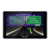
Explains how to use the Highway Page via menu and software buttons.
Explains how to interpret the echogram, identifying fish, thermoclines, and bottom structure.
Covers functions like layout customization, data options, and split screen modes.
Customizing data displayed in each field.
Covers functions for managing combo page layouts and windows.
Procedure to customize data displayed in combo windows.
Adjusting the size ratio between the two displayed combo screens.
Procedure to customize data displayed in split screen windows.
Adjusting the size ratio of split screen windows.
Allows measuring distance and bearing between two points on the chart.
Process for creating new routes and naming them.
Controls screen brightness, contrast, and color palettes for optimal visibility.
Adjusts background color, scrolling speed, white line, and fish symbols.
Adjusts settings related to the sonar transducer, like offset and calibration.
Configures various alarms for depth, temperature, GPS, and other conditions.
Configures sensitivity presets, frequency, and gain for optimal sonar performance.
Alarms related to GPS functions like anchor position, arrival, and cross-track error.
Explains how to connect power, GPS, NMEA, and other devices.
Instructions for connecting external NMEA devices to the chartplotter.
How to connect the GPS antenna to the chartplotter.
Connecting autopilot and DSC VHF radio systems.
Instructions for running diagnostic tests to identify potential problems.
Details the MF 2500 Fish Finder sonar module and its capabilities.
Describes the principles of GPS operation, including satellite signals and receivers.
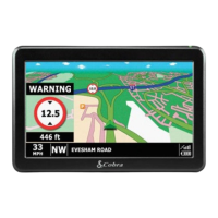
| GPS | Yes |
|---|---|
| Radar detection | Yes |
| Laser detection | Yes |
| Display | Color LCD |
| Bluetooth | Yes |
| Voice Guidance | Yes |
| Lane Assistance | Yes |
| Speed Limit Alerts | Yes |
| Points of Interest | Yes |
| Type | GPS Navigation System |
| Traffic Updates | Yes |