26 RetroSign GR1 & GR3 · Retroreflectometer
APPENDIX D – GPS
GPS Implementation
The GPS function is activated when the GPS Option has been enabled in the menu. Due to the fact that the GPS receiv-
er first has to receive signals from several satellites before it can calculate its position, it will take a short time before a
“Good Fix” can be achieved. Typical this process will take only a few seconds but depends on how long the device has
been out of use and also on how far it has been moved away from the last fix position.
When the GPS function is enabled but no fix has yet been calculated the icon row shows (strikeout)
When a position has been calculated, the Icon changes to and the position and status will be updated. The GPS
position data and status can be displayed by selecting Info page: GPS. This is done by pressing two times from the
main result display. See. Appendix F Result and Info Pages
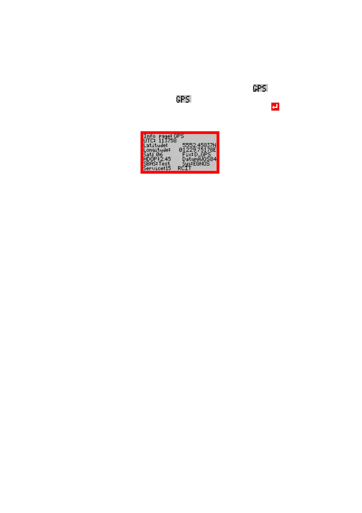
Display example:
Line 2: UTC: 113758 universal time code (London time)
Line 3: Latitude: 5552.45837N format ddmm.mmmm
Line 4: Longitude: 01229.75178E format dddmm.mmmm
Line 5: Sat: 06 Number of satellites used
Line 5: Fix: D_GPS Fix type
Line 6: HDOP: 2.45 Horizontal Dilution Of Precision
Line 6: Datum: WGS84 Map reference system
Line 7: SBAS Test Satellite Based Augmentation Systems
Line 7: Sys: EGNOS The position correction system in use
Line 8: Service: 15 RCIT system service status bitmap (4 bit)
Fix: The Fix type can be:
■ NoFix Invalid position
■ 2D/3D Standard GPS
■ D_GPS Differential GPS
■ Estim Estimated (Dead Reckoning) Fix
HDOP: The Horizontal Dilution Of Precision HDOP value in the range from 0.10 to 99.99, the lower the value the more
accurate the position Fix.
Datum: The Map reference system can only be changed with the RSC2 software.
Sys: The DGPS mode received by the GPS unit, it can be:
■ GPS when no correction data is received.
■ WAAS when correction data from the WAAS satellites is used
■ EGNOS when correction data from the EGNOS satellites is used
■ Unknown when ambiguous correction data.
Service: R: Ranging, C: corrections, I: integrity, T: test mode
All GPS Position data and status are stored in the internal data log and will be retrieved with the normal Log Dump ac-
tion.