Do you have a question about the Garmin 50LM and is the answer not in the manual?
Warnings related to safely installing the device in a vehicle to avoid obstructing view or interfering with controls.
Guidelines for safe on-road navigation, emphasizing driver attentiveness and judgment.
Precautions and warnings regarding the device's lithium-ion battery to prevent damage or hazards.
Information on checking state and local laws regarding windshield mounting of devices.
Clarification that the speed limit feature is informational and does not replace driver responsibility.
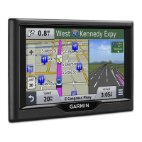
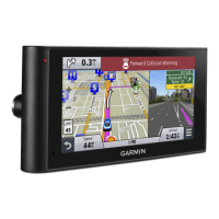
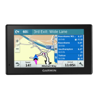
Detailed description of the Garmin DriveSmart 50LM device and its components.
Instructions for connecting the device to the vehicle's power source for charging and operation.
Procedures for powering the device on, off, and entering power saving mode.
Steps to acquire satellite signals required for navigation.
Explanation of the icons displayed in the device's status bar and their meanings.
Guide to using the device's on-screen buttons for navigation and menu interaction.
Instructions for adjusting the audio volume levels on the device.
How to enable automatic volume adjustment based on background noise.
How to set individual volume levels for different audio types.
Steps to adjust the brightness of the device's display.
Overview of features designed to enhance driver awareness and provide alerts.
How to enable or disable audible alerts for various driver warnings.
Definition of a route and how the device calculates it based on preferences.
Step-by-step guide to initiating navigation to a destination.
How to view the calculated route and its details on the map display.
How to start navigation by selecting a location directly from the map interface.
Setting up and navigating to the user's home location.
How to view upcoming turns, lane changes, and detailed navigation instructions.
Instructions for adding intermediate stops or destinations to an active route.
Manually adjusting a route to include specific roads or areas.
How to create a detour around specific roads or distances due to road conditions.
How to end the current navigation session on the device.
Options for changing how the device calculates routes (e.g., fastest time, shortest distance).
Features for planning, saving, and navigating multi-destination trips.
Step-by-step guide to creating a new trip with multiple destinations and waypoints.
How to start navigation for a previously saved trip from the Trip Planner.
How the device automatically optimizes destination order for a more efficient route.
How to modify existing trips by adding, removing, or reordering locations.
How to edit an active route and save it as a trip.
How to customize route calculation settings for a specific trip.
How to add arrival times and layover durations for trip locations.
How the device suggests routes based on travel history and time of day.
How to configure the device to avoid toll roads, bridges, and congestion areas.
How to avoid specific road features like unpaved roads or ferries.
How to define specific roads or areas to avoid on routes.
How to use the device for navigation when not following standard roadways.
Methods for searching for locations using keywords, categories, addresses, or city names.
How to adjust the geographical area for location searches.
Information on browsing and finding points of interest by category.
Step-by-step guide to finding locations using predefined categories.
How to find locations within specific categories, including quick search lists.
Information about using Foursquare integration for location data and features.
How to search for Foursquare locations and integrate with Smartphone Link for results.
Steps to link your device to a Foursquare account via Smartphone Link.
How to check into Foursquare locations using the device.
Using specialized tools to find specific types of locations.
Detailed instructions for searching for locations by street address.
How to find a location by specifying an intersection of roads.
Methods for searching for cities, including nearby cities or by name.
How to find a location using latitude and longitude coordinates.
How to view information about your current location, useful for emergency services.
How to find nearby hospitals, police stations, and fuel stations.
How to remove the history of recently found locations.
How the device saves your last parking location automatically.
How to create shortcuts to frequently accessed locations or features in the Where To? menu.
How to delete existing shortcuts from the Where To? menu.
General instructions for saving favorite locations for quick access.
Detailed steps for saving a specific location with a custom name.
How to save the device's current location as a favorite.
How to modify the details of a saved location.
How to organize saved locations using custom categories.
How to remove saved locations from the device.
How to interact with the map display for navigation and exploration.
Quick access to device functions and information while viewing the map.
How to select and display a specific map tool on the screen.
How to customize the map tools menu by adding or removing tools.
Tool that displays upcoming points of interest like restaurants or rest areas.
How to view details about upcoming points of interest from the Up Ahead tool.
How to customize the categories shown in the Up Ahead tool.
Accessing and viewing trip-related data and statistics.
How to display trip data fields directly on the map.
How to select which data fields are displayed in the trip data tool.
How to access the dedicated page showing trip speed and statistics.
How to view a record of the paths the device has traveled.
How to reset trip data fields, trip computer, or odometer.
How to customize the data and icons displayed on the map.
How to change the type of data displayed in a map data field.
How to switch between 2D (Track Up, North Up) and 3D map views.
How to set a custom phrase to activate voice command features.
How to activate the voice command interface by saying the wakeup phrase.
Advice for improving voice recognition accuracy and usability.
How to initiate navigation to a location using voice commands.
How to disable voice prompts for voice command without muting the device.
How to set up voice control for a single user by recording commands.
How to use the configured voice control features to operate the device.
Advice for improving the accuracy and effectiveness of voice control.
How to place and receive calls using the device and a paired phone.
How to view phone notifications and messages on the device.
How to send location data from your smartphone to the navigation device.
How to check into Foursquare locations using the navigation device.
How to receive real-time weather conditions and alerts on the device.
Detailed steps for pairing your phone with the device and connecting to the Smartphone Link app.
Explanation of status icons indicating Bluetooth connection status.
How to configure Bluetooth features for Apple devices.
Steps to connect to the Smartphone Link app on an Apple device.
How to disable hands-free calling while remaining connected for data.
How to disable data and notifications for Apple devices.
How to filter notifications displayed on the device for Apple devices.
How to configure Bluetooth features for Android devices.
Steps to connect to the Smartphone Link app on an Android device.
How to disable specific Bluetooth features for Android devices.
How to select notification types for Android devices.
Overview of the Smartphone Link application and its functionalities.
Where and how to download the Smartphone Link application.
How to send location data from your smartphone to the navigation device.
How to view smartphone notifications like texts and calls on the device.
How the device displays incoming notifications from a connected smartphone.
How notifications appear and are managed when the map is displayed.
How to view a list of all active notifications received by the device.
How to initiate a phone call using the device.
How to call contacts from the phone's synced contact list.
How to call a location directly from the device's points of interest.
How to answer or ignore incoming calls on the device.
How to view and access the call history loaded from the phone.
How to use various options during an active phone call.
How to save your home phone number for quick dialing.
How to access the device's built-in help system.
How to find specific information within the help system.
How to display current weather conditions and forecasts.
How to view weather information for cities other than your current location.
How to view a history of previously navigated routes and visited places.
Settings related to map display, vehicle icon, and map detail.
How to enable installed map products on the device.
Settings related to route calculation, avoidances, and warnings.
Options for setting route calculation preferences like Faster Time or Shorter Distance.
How to set a simulated location for testing or when GPS signals are unavailable.
Settings for managing Bluetooth connections, devices, and friendly names.
How to turn off the device's Bluetooth functionality.
Settings for display orientation, color mode, brightness, and timeout.
Settings for units of measure, time format, and current time.
How to set the device's current time automatically or manually.
Settings for voice language, text language, and keyboard layout.
How to configure alerts for approaching points of interest.
Settings related to device information, privacy, position reporting, and travel history.
How to restore device settings to factory defaults.
Technical specifications of the device, including temperature ranges and power input.
Information on various ways to power the device.
Information on registering the device and updating software and maps.
Recommendations for maintaining the device and avoiding damage.
Instructions for cleaning the device's exterior casing.
Instructions for cleaning the device's touchscreen display.
Tips for preventing theft of the device and mount.
How to reset the device if it stops functioning properly.
Step-by-step guide for detaching the device, mount, and suction cup.
Instructions for replacing the fuse in the vehicle power adapter.
Solutions for issues with the suction cup mount failing to adhere to the windshield.
Steps to troubleshoot problems with the device not receiving GPS signals.
Solutions for the device not charging when connected to the vehicle's power.
Tips for improving battery life and troubleshooting rapid discharge.
How to resolve issues where the device is not recognized as a drive by a computer.
Troubleshooting why the device might not appear as a portable device on a computer.
Solutions for when the device doesn't appear as a removable drive or volume on a computer.
Troubleshooting steps for establishing a Bluetooth connection between the phone and the device.
Instructions for installing a memory card for maps and data storage.
Information about storing and managing files on the device's memory card.
Details about compatible memory card types and their uses.
How to connect the device to a computer using a USB cable.
How to copy files from a computer to the device's storage.
Procedures for safely disconnecting the USB cable from the computer and device.
How to check the status of GPS satellite signal acquisition.
Information on how to buy and install more map products.
Information on where to purchase additional accessories for the device.
| Display Size | 5.0 inches |
|---|---|
| Display Resolution | 480 x 272 pixels |
| Display Type | WQVGA color TFT with white backlight |
| Preloaded Maps | Yes |
| Accepts Data Cards | microSD card |
| Battery | rechargeable lithium-ion |
| Battery Life | up to 1 hour |
| Voice-activated Navigation | No |
| Bluetooth | No |
| Lane Assist | Yes |
| Speed Limit Indicator | Yes |