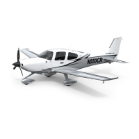
Do you have a question about the Garmin Cirrus Perspective SR22T and is the answer not in the manual?
Procedure to set the barometric pressure for altimeter.
Procedure to switch between GPS, VOR1, LOC1, VOR2, and LOC2 navigation sources.
Instructions for using the built-in generic timer function.
Procedure to set and adjust V-speed bugs for flight reference.
Overview of the Engine Page displaying engine, fuel, and air data information.
Explanation of fuel calculation group and adjusting totalizer quantity.
Guide to accessing and using the Leaning Assist Mode for engine leaning.
Procedure for tuning the Distance Measuring Equipment (DME) source.
Instructions for entering a transponder code via softkeys or keypad.
Explanation of Split COM operation allowing simultaneous transmissions.
Details on ICS isolation modes for pilot, copilot, and passenger audio.
Overview of the GFC 700 Autopilot system and its functions.
Description of available vertical modes for autopilot control.
Description of available lateral modes for autopilot control.
Procedure for navigating directly to a selected waypoint using MFD or PFD.
Instructions for activating a previously stored flight plan.
Explanation of VNAV functionality and altitude constraints.
Guide to planning a trip, including direct-to and point-to-point planning.
Procedures for creating user waypoints by various methods.
Instructions for creating active and stored flight plans.
Procedures for importing flight plans from SD cards and exporting them.
Steps to load and activate departure procedures and transitions.
Instructions for loading arrival procedures, including transitions and runways.
Guide to loading and activating instrument approach procedures.
How to customize hazard displays like weather and traffic on the navigation map.
Information on displaying and using the Stormscope lightning detection system.
Procedures for displaying SiriusXM weather products on the navigation map.
How to display terrain and obstacle proximity information.
Overview and display instructions for the Synthetic Vision System (SVS).
Guide to accessing and adjusting the Enhanced Vision System (EVS) display.
Instructions for selecting channels and adjusting volume for SiriusXM radio.
Steps for setting up, editing, connecting, and disconnecting Wi-Fi networks.
Explanation of system behavior during failure and reversionary mode activation.
Details on Dead Reckoning Mode when GPS position is lost or invalid.
Explanation of system annunciations when LRU functions fail.
List of system warning alerts, their window text, and audio alerts.
List of system caution alerts, their window text, and audio alerts.
Advisories related to navigation, terrain, and obstacle database errors.
Diagram illustrating the PFD softkey hierarchy and options.
Diagram illustrating the MFD softkey hierarchy and options.
Procedure for updating system databases via SD card.
Steps to load the active navigation database from an SD card.
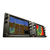
| Display Type | LCD |
|---|---|
| Primary Flight Display (PFD) | Yes |
| Multifunction Display (MFD) | Yes |
| Resolution | 1280 x 800 pixels |
| Display Size | 12.1 inches |
| Operating Temperature | -20°C to +55°C |
| Certification | TSO |