EasyManua.ls Logo

Garmin GRS 77 User Manual

Garmin GRS 77
482 pages
To Next Page IconTo Next Page
Page #1 background imageLoading...
Page #1 background image
Garmin International, Inc.
1200 East 151st Street
Olathe, Kansas 66062, U.S.A.
Garmin AT, Inc.
2345 Turner Road SE
Salem, OR 97302, U.S.A.
Garmin (Europe) Ltd.
Liberty House, Hounsdown Business Park
Southampton, Hampshire SO40 9LR U.K.
Garmin Corporation
No. 68, Zhangshu 2nd Road
Xizhi District, New Taipei City, Taiwan
Contact Garmin Product Support or view
warranty information at flygarmin.com.
Piper PA-32 Saratoga
System Software Version 2824.02 or later
G1000
®
Integrated Flight Deck
Pilot’s Guide
G1000
®
Pilot’s Guide
Piper PA-32 Saratoga
190-02692-00
Revision A

Table of Contents

Other manuals for Garmin GRS 77

Question and Answer IconNeed help?

Do you have a question about the Garmin GRS 77 and is the answer not in the manual?

Garmin GRS 77 Specifications

General IconGeneral
BrandGarmin
ModelGRS 77
CategoryAvionics Display
LanguageEnglish

Summary

SECTION 1 SYSTEM OVERVIEW

SECTION 2 FLIGHT INSTRUMENTS

2.1 FLIGHT INSTRUMENTS

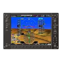
Description of instruments displayed on the Primary Flight Display (PFD).

2.4 PFD ANNUNCIATIONS AND ALERTING FUNCTIONS

Explanation of PFD alerts, including marker beacon, altitude, and low altitude annunciations.

SECTION 3 ENGINE INDICATION SYSTEM

3.1 ENGINE DISPLAY

Description of the engine display parameters including manifold pressure and tachometer.

SECTION 4 AUDIO PANEL AND CNS

4.2 COM OPERATION

Procedures for tuning COM frequencies, including manual and auto-tuning.

4.3 NAV OPERATION

Procedures for selecting NAV radios, manual tuning, and auto-tuning frequencies.

SECTION 5 FLIGHT MANAGEMENT

5.2 USING MAP DISPLAYS

Guidance on using map displays, including orientation, range, and declutter.

5.3 WAYPOINTS

Information on selecting, creating, and managing waypoints.

5.6 FLIGHT PLANNING

Methods for creating and modifying flight plans and airways.

5.8 PROCEDURES

Loading and activating departures, arrivals, and approaches.

SECTION 6 HAZARD AVOIDANCE

6.1 SIRIUSXM WEATHER

Activating and using SiriusXM Weather products for flight advisories.

6.4 TERRAIN PROXIMITY

Displaying terrain and obstacle information for situational awareness.

6.5 TERRAIN-SVS

Using Synthetic Vision System for terrain awareness.

6.6 TAWS-B

Understanding Terrain Awareness and Warning System (TAWS-B) alerts.

6.8 TRAFFIC INFORMATION SERVICE (TIS)

Assisting flight crew in detection and avoidance of other aircraft.

6.10 GARMIN ADS-B TRAFFIC

Overview of ADS-B traffic system and capabilities.

APPENDIX B DATABASE MANAGEMENT

NAVIGATION DATABASES

Information on navigation database updates and installation.

UPDATING GARMIN DATABASES/JEPPESEN CHARTVIEW DATABASE

Instructions for updating basemap, SafeTaxi, obstacle, and airport directory databases.

Related product manuals