Do you have a question about the Garmin GMU 44 and is the answer not in the manual?
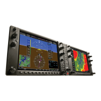
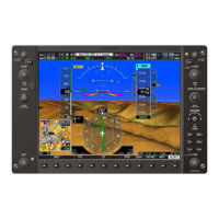
Provides an overview of the G1000 Integrated Avionics System as installed in the Piper PA-32 Saratoga.
Details the Primary Flight Display (PFD) and the Multifunction Flight Display (MFD) and their associated units.
Explains the use of SD cards for databases, software updates, and flight data recording.
Describes the system initialization process and initial screen displays upon power application.
Covers normal and reversionary display operations, AHRS modes, and system annunciations.
Details annunciations and alerts for instrument failures and system status.
Explains AHRS operation, including modes, input sources, and magnetic field variation.
Details the operation of GPS receivers, including status viewing and RAIM prediction.
Explains how to disable SBAS and describes GPS signal strengths.
Describes the PFD/MFD controls and softkeys for simplifying operation.
Explains the location and function of softkeys on the displays.
Details the functions of PFD softkeys for flight management and configurations.
Highlights PFD softkey data that displays differently in Reversionary Mode.
Describes MFD softkey functions for controlling and viewing various system features.
Explains how to access system functionality through menus and data entry.
Describes how to navigate menus and access context-sensitive options.
Explains how information is presented on MFD pages grouped by function.
Details how to select pages using the FMS Knob for navigation.
Covers the two system pages in the Auxiliary Page Group: System Setup and System Status.
Allows management of various system parameters like pilot profiles and display units.
Explains how system settings can be saved, created, selected, renamed, or deleted.
Provides instructions for importing pilot profiles from an SD card.
Details the process of exporting pilot profiles to an SD card.
Explains how the system obtains and displays the current UTC date and time.
Outlines options for displaying measurements and units on the AUX – SYSTEM SETUP Page.
Describes how to set the audio alert voice to male or female.
Explains how to define the scale for the Course Deviation Indicator when GPS is the source.
Allows the pilot to select COM frequency channel spacing.
Displays status and software versions for detected LRUs and system databases.
Provides access to timers, trip statistics, and a scheduler feature.
Explains how to set, start, stop, and reset the generic timer.
Describes the scheduler feature for entering and displaying reminder messages.
Details how trip statistics are calculated based on selected waypoints and trip planning inputs.
Explains how to adjust display and key backlighting automatically or manually.
Describes the airspeed indicator, including indicated airspeed, trend vector, and V-speeds.
Details the attitude indicator's display of pitch, roll, and slip/skid information.
Explains the altimeter's display of altitude, trend vector, and barometric pressure setting.
Describes how to choose display units and metric altitude overlays.
Explains how to adjust the altimeter barometric pressure setting.
Details the VSI's display of aircraft vertical speed.
Describes the VDI for baro-VNV vertical deviation and the Glideslope Indicator.
Explains the HSI display, including compass card, track, course deviation, and bearing.
Describes the turn rate indicator and its trend vector.
Explains how to display bearing pointers and associated information on the HSI.
Details the DME Information Window display and tuning.
Explains CDI movement relative to course and its display sources (GPS, VOR/LOC).
Describes how GPS CDI scale is displayed and changed based on flight phase.
Covers abnormal GPS conditions, heading failure modes, and SVT troubleshooting.
Lists annunciations that can appear on the HSI during abnormal GPS conditions.
Explains HSI displays when heading information is unavailable.
Details when SVT is disabled and the required data resources.
Describes how the display changes during extreme pitch attitudes.
Details annunciations and alerting functions pertaining to flight instruments on the PFD.
Describes marker beacon annunciations on the PFD and their relation to the audio panel.
Provides visual and aural alerts when approaching the Selected Altitude.
Explains the 'LOW ALT' annunciation during GPS approaches with SBAS vertical guidance.
Describes how to set a minimum altitude and the associated visual annunciations.
Shows engine parameters like manifold pressure, tachometer, fuel quantity, and flow.
Details the EIS display and the engine softkey functions.
Explains the functions of softkeys for accessing engine, fuel, electrical data, and fuel calculations.
Describes how fuel calculations are based on fuel flow totalizer and displayed fuel remaining.
Presents PFD symbology with the EIS display in Reversionary Mode.
Details engine softkey functions when operating in reversionary mode.
Provides information and interface for performing engine leaning.
Shows engine manifold pressure, tachometer, fuel quantity, flow, calculations, and electrical indications.
Introduces the Communication/Navigation/Surveillance (CNS) system components and LRUs.
Details the controls for tuning communication and navigation radios.
Describes the functions of the audio panel controls for microphone and receiver audio selection.
Explains COM tuning boxes, transmit/receive indications, and manual tuning.
Details the structure of the COM Frequency Box and how radios are selected for transmit.
Explains the white TX and RX indicators during COM transmission and reception.
Provides step-by-step instructions for manually tuning a COM frequency.
Explains how to move the tuning box between COM1 and COM2 frequency fields.
Describes how to tune the emergency COM frequency.
Lists sources from which COM frequencies can be automatically tuned.
Details how to auto-tune COM frequencies for nearby airports from the PFD.
Explains how to auto-tune COM frequencies from NRST or WPT pages on the MFD.
Covers tuning COM radios with 25-kHz or 8.33-kHz spacing.
Explains how automatic squelch quiets static noise and how to disable it.
Describes how to adjust COM radio volume levels.
Covers NAV radio selection, activation, manual tuning, and VOR/LOC ID.
Explains how to select NAV radios for navigation using the CDI Softkey.
Provides instructions for manually tuning NAV frequencies.
Describes how to switch the tuning box between NAV radios.
Explains how Morse code identifiers are displayed and verified for NAV radios.
Describes how to adjust NAV radio volume levels.
Explains how to auto-tune NAV frequencies from MFD pages.
Details how NAV frequencies are auto-tuned upon loading a VOR or ILS/Localizer approach.
Describes the marker beacon receiver operation and its annunciations.
Explains how to tune the ADF receiver and DME transceiver.
Provides instructions for tuning ADF frequencies.
Details the selectable modes for the ADF receiver.
Explains how to adjust the ADF receiver volume.
Describes DME transceiver tuning and pairing options.
Covers Mode S transponder capabilities and interrogation/reply functions.
Details the transponder controls displayed on the PFD, including mode and code selection.
Explains automatic and manual transponder mode selection.
Describes how to select Standby Mode and its limitations.
Explains how to select On Mode for transmission of replies and squitters.
Details how to select Altitude Mode for transmission of replies and squitters.
Describes the white 'R' indication in the reply status field when the transponder sends replies.
Explains how to enter the VFR code manually or via softkeys.
Provides methods for entering transponder codes using softkeys or the FMS Knob.
Explains how the IDENT softkey sends a distinct identity indication to ATC.
Covers power application, intercom, and passenger address system functions.
Describes the audio panel's self-test upon power application.
Provides recommendations for headset use in the aircraft.
Explains how to use the cabin speaker and its volume adjustment.
Details the intercom system and isolation controls.
Explains how the PILOT/PASS Knob controls volume and squelch.
Describes the passenger address system for delivering voice messages.
Details the digital clearance recorder for COM radio signal.
Explains Split COM operation for simultaneous transmission over separate radios.
Introduces the integrated flight, engine, communication, navigation, and surveillance system.
Indicates the sensor providing course data and the flight plan phase.
Describes the small version of the MFD Navigation Map displayed on the PFD.
Explains the four orientation options for map displays.
Details the available map ranges and how to change them.
Allows the system to adjust map display range to the smallest range showing the active waypoint.
Allows viewing map parts outside the displayed range and highlighting locations.
Explains how to calculate bearing and distance from aircraft position to map points.
Describes how to display or remove topography colors representing land elevation.
Discusses types of land and aviation symbols that can be displayed.
Lists land symbols and their configuration options.
Details aviation symbols and their configuration options.
Explains the North American airway structure and display options.
Covers displaying/removing land symbols and selecting text size and range.
Allows progressive removal of map information through four declutter levels.
Describes additional items like track vector, wind vector, and fuel range ring.
Explains the track vector for minimizing track angle error.
Describes the wind vector arrow and how to display/remove it.
Shows direction of travel (ground track) on a rotating compass card.
Displays remaining flight distance and reserve fuel indicators.
Shows the boundaries of the PFD Synthetic Vision Technology (SVT) lateral field of view.
Displays the location where the aircraft will intercept the selected altitude.
Describes predetermined geographical positions used for flight planning and navigation.
Explains how to enter identifiers, facility names, or city names for waypoints.
Details how to select waypoints from the database or map.
Provides information on airports, including frequencies, runways, and procedures.
Instructions for reviewing airport information by identifier, facility, or location.
Details how to select a specific runway for an airport.
Explains how to view the destination airport information.
Describes how to view runway information for a specific airport.
Covers selecting criteria for nearest airport surface matching.
Explains how to select criteria for minimum runway length.
Provides information about intersections and their display on the map.
Details how to select an intersection for review.
Provides information about NDBs and their display on the map.
Details how to select an NDB for review.
Provides information about VORs and ILS signals and auto-tuning frequencies.
Details how to select a VOR for information.
Provides information about visual reporting points (VRPs) and their display.
Details how to select a VRP for information.
Explains how to create and store up to 1,000 user-defined waypoints.
Provides instructions for selecting a user waypoint.
Details how to create user waypoints from the WPT page or map pages.
Explains how to edit comments, locations, rename, or delete user waypoints.
Provides instructions for renaming user waypoints.
Explains how to delete single or all user waypoints.
Displays various types of airspaces like Class B, TMA, and Airways.
Allows progressive removal of map information through four declutter levels.
Describes additional items like track vector, wind vector, and fuel range ring.
Explains the track vector for minimizing track angle error.
Describes the wind vector arrow and how to display/remove it.
Shows direction of travel (ground track) on a rotating compass card.
Displays remaining flight distance and reserve fuel indicators.
Shows the boundaries of the PFD Synthetic Vision Technology (SVT) lateral field of view.
Displays the location where the aircraft will intercept the selected altitude.
Covers building a flight plan by entering waypoints and procedures.
Details the three methods to create or modify a flight plan.
Explains how to configure the active flight plan for cumulative or leg-to-leg distance.
Provides an overview of basic flight plan creation.
Explains how to edit waypoints and airways in any flight plan.
Describes how to add a waypoint to an active or stored flight plan.
Explains how to remove individual waypoints or airways from a flight plan.
Describes how to collapse or expand airways in the active flight plan.
Covers activating flight plan legs and conducting enroute operations.
Explains how to select and activate the next leg of the active flight plan.
Details how to enter waypoints with along track offsets for altitude constraints.
Allows creation of a parallel course offset of 1 to 50 nm left or right of the current flight plan.
Calculates bearing and distance to a reference waypoint and creates a new user waypoint.
Describes how to define a holding pattern at an active waypoint or present position.
Provides steps to create a user-defined hold at an active flight plan waypoint.
Details creating a user-defined hold at the aircraft's present position.
Explains how to create a user-defined hold at a direct-to waypoint.
Allows setting arrival alert messages and trigger distance.
Covers managing flight plans by importing, exporting, storing, copying, and deleting.
Provides instructions for importing flight plans from an SD card.
Details the process of exporting flight plans to an SD card.
Explains how to invert a flight plan for navigation back to the original departure point.
Describes how the active flight plan is erased or deleted.
Covers viewing, editing, copying, and deleting stored flight plans.
Discusses loading, activating, and removing GPS and NAVAID instrument approach procedures.
Provides guidance for non-precision and precision approaches.
Explains RNAV/GPS approach procedures and their service levels.
Describes behavior when SBAS is lost during approach.
Covers selecting and removing approaches from the active flight plan.
Details loading approaches using the PROC Key.
Explains how to remove an arrival from the active flight plan.
Describes system guidance for missed approaches.
Explains temperature compensation for approach waypoint altitudes and minimums.
Provides steps to manually enable temperature compensation for waypoint altitudes.
Details how to cancel temperature compensation for approach waypoint altitudes.
Describes entering a temperature compensated minimum descent altitude for an approach.
Covers inputting data for weight and fuel planning calculations.
Explains the AUX - WEIGHT AND FUEL PLANNING Page for calculations.
Provides steps for entering the basic empty weight.
Details how to enter pilot and stores weight.
Explains how to enter the number of passengers.
Describes how to enter the average passenger weight.
Provides steps for entering the cargo weight.
Details how to enter the fuel on board weight.
Explains how to enter the fuel reserves amount.
Lists conditions displayed in red for estimated landing fuel weight.
Allows viewing trip planning, fuel, and weight information.
Explains inputting data for calculation and viewing of statistics on the AUX – TRIP PLANNING Page.
Details how trip statistics are calculated based on selected waypoints and trip planning inputs.
Covers fuel statistics calculation based on waypoints and trip planning inputs.
Lists statistics calculated from system sensor or manual trip inputs.
Addresses abnormal operation of the G1000, including Dead Reckoning Mode.
Explains DR Mode operation when GPS solution is invalid.
Lists available weather features: SiriusXM Weather, FIS-B Weather, and Stormscope.
Covers Terrain Proximity, Terrain-SVS, and TAWS-B systems.
Lists Traffic Information Service (TIS), Skywatch SKY497, and ADS-B Traffic.
Details SiriusXM Weather information and service activation.
Provides instructions for activating SiriusXM Weather and establishing an account.
Guides the pilot through establishing a SiriusXM account.
Explains how to view and customize SiriusXM Weather data on map pages.
Details how to change the weather data link source (SiriusXM, Garmin Connext, FIS-B).
Covers FIS-B weather data reception and product display.
Explains how to view FIS-B weather data on map pages.
Guides the pilot on changing the weather data link source.
Details Stormscope operation, including cell and strike modes.
Explains how to set up Stormscope options on the MAP - NAVIGATION MAP Page.
Describes cell and strike modes for lightning activity display.
Provides instructions for manually clearing Stormscope data.
Explains how to select Stormscope display ranges on the Navigation Map.
Details how to select the MAP - STORMSCOPE® Page.
Describes how to change between cell and strike modes for Stormscope.
Covers terrain awareness system that increases situational awareness.
Explains how to display terrain and obstacle information on the MAP - TERRAIN PROXIMITY Page.
Describes Terrain-SVS as a terrain awareness system integrated with SVS.
Explains how Terrain-SVS uses colors to depict terrain and obstacles.
Details how to inhibit or enable Terrain-SVS alerts.
Compares aircraft flight path with known terrain and obstacles to issue alerts.
Explains the Premature Descent Alert (PDA) issued when aircraft is below normal approach path.
Provides increased situational awareness and aids in reducing controlled flight into terrain.
Explains how TAWS-B uses colors to depict terrain and obstacles.
Specialized page for viewing TAWS-B information.
Describes TAWS-B alerts and their corresponding annunciations and voice alerts.
Assists in detection and avoidance of other aircraft using Mode S transponder data.
Describes ADS-B as a core technology in the FAA NextGen air traffic control system.
Explains the rebroadcast of ADS-B data by FAA ground stations.
Details how Skywatch SKY497 Traffic Advisory System correlates traffic.
Describes the CSA alerting algorithm for ADS-B traffic.
Explains the symbols used to display ADS-B traffic.
Covers traffic system transitions between STANDBY and OPERATE modes.
Shows surrounding traffic data relative to aircraft position and altitude.
Allows pilot to select the volume of airspace for displaying traffic.
Explains how to enable/disable the display of Flight IDs of other aircraft.
Details how to display traffic information on the PFD inset maps.
Explains how to customize traffic display settings on the MAP - NAVIGATION MAP Page.
Covers the optional S-TEC Fifty Five X Autopilot.
Discusses the additional 'FD' mode annunciation in the G1000 AFCS Status Box.
Explains the use of the ALT Knob for entering selected altitude.
Provides detailed taxiway, runway, and ramp information at airports.
Offers on-board electronic terminal procedures charts for access to essential information.
Explains the three levels of softkeys for ChartView functions.
Provides instructions for selecting terminal procedure charts.
Details how to select airport diagrams or approach charts.
Resembles paper terminal procedures charts, displayed with high-resolution and color.
Explains the softkey levels for FliteCharts functions.
Provides instructions for selecting terminal procedures charts.
Details how to select airport diagrams or approach charts.
Offers SiriusXM Satellite Radio entertainment services for pilots and passengers.
Provides instructions for activating SiriusXM Satellite Radio services.
Explains how to use the XM Radio Page for audio entertainment.
Displays the currently selected channel and lists available channels.
Shows the currently selected audio category and allows selection of content types.
Explains how to assign and select preset channel numbers.
Describes how to adjust radio volume levels.
Automatically stores critical flight and engine data on an SD data card.
Allows pilots to quickly find procedures for different flight phases.
Provides steps to access and navigate electronic checklists.
Explains how to access emergency checklists.
Offers troubleshooting steps for SiriusXM Data Link Receiver failures.
Guides the user to select the System Status Page for LRU information.
Explains how the Alerting System conveys alerts through CAS, ALERTS Window, and softkeys.
Details the three alert levels (warning, caution, advisory) and their sorting.
Describes various system message advisories related to LRU or function failures.
Provides information on database updates and potential inaccuracies.
Explains navigation database updates and installation methods.
Details the procedure for updating the active navigation database.
Allows each display to store an upcoming navigation database on the bottom SD card.
Provides instructions for loading a standby navigation database.
Lists databases stored on Supplemental Data Cards provided by Garmin.
Automatically transfers databases from one SD card to others for synchronization.
Covers updating Terrain, ChartView, and FliteCharts databases.
Explains how to update the magnetic field variation database.
Provides a glossary of aviation terms and acronyms used in the document.
Addresses common questions regarding system operational capability.
Explains the Satellite Based Augmentation System (SBAS) and its functions.
Describes how SBAS accuracy impacts instrument approaches.
Explains RAIM and its effect on approach operations.
Addresses situations where no approaches are available for a flight plan.
Explains what happens when an approach, departure, or arrival is loaded or stored.
Answers whether "slant Golf" can be filed using the G1000.
Explains the function of the OBS Softkey for manual waypoint sequencing.
Addresses why the system might not automatically sequence to the next waypoint.
Explains how a pilot can manually select any approach, departure, or arrival leg.
Describes when turn anticipation begins based on pilot cues.
Explains how the CDI scale changes based on flight phase and approach activation.
Compares HSI response in OBS mode to a VOR.
Addresses the correct missed approach procedure and holding point selection.
Explains how to reactivate or activate a new approach after a missed approach.
| Brand | Garmin |
|---|---|
| Model | GMU 44 |
| Category | Avionics Display |
| Language | English |