Do you have a question about the Garmin GMA 1347 and is the answer not in the manual?
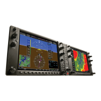
Provides an overview of the G1000 Integrated Avionics System as installed in the Piper PA-32 Saratoga.
Describes normal and reversionary system display operation, including AHRS modes and system annunciations.
Details the PFD/MFD controls and softkeys, essential for system operation and workload management.
Describes the Primary Flight Display (PFD) and its various flight instruments, including airspeed, attitude, and heading.
Presents the Engine Indication System (EIS) display, showing electrical, fuel, and engine parameters on the MFD.
Covers COM tuning boxes, manual tuning, auto-tuning, frequency spacing, and automatic squelch.
Details NAV radio selection, activation, manual tuning, and auto-tuning from the MFD.
Explains transponder controls, mode selection, code entry, and the IDENT function.
Explains how to use map displays for situational awareness, covering information, orientation, and range.
Details how to select, enter, and manage waypoints for flight planning and navigation.
Explains how to initiate direct-to navigation to waypoints, airports, or map pointers for quick navigation.
Covers building a flight plan by entering waypoints, airways, departures, arrivals, and approaches.
Explains how the system provides vertical path guidance and altitude constraints for enroute and terminal phases.
Details how to access instrument procedures like Departures (DPs), Arrivals (STARs), and Approaches (APPRs).
Details how to activate and use SiriusXM Weather services, including graphical weather and text information.
Details the TAWS-B system, its requirements, alerts, and abnormal conditions for terrain and obstacle avoidance.
Covers TIS operation, symbology, alerts, and system status for detecting and avoiding other aircraft.
Covers obtaining, installing, and synchronizing navigation and other databases from third-party sources.
| Brand | Garmin |
|---|---|
| Model | GMA 1347 |
| Category | Avionics Display |
| Language | English |