Do you have a question about the Garmin GDU 1040 and is the answer not in the manual?
Covers normal and reversionary display modes, system annunciations, and AHRS operational modes.
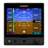
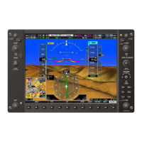
Describes the PFD display of flight instruments including airspeed, attitude, altimeter, VSI, HSI, and related data.
Explains Garmin Synthetic Vision Technology (SVT) as a visual enhancement for topography and flight path depiction.
Covers PFD annunciations and alerting functions including marker beacon, altitude, low altitude, and minimum altitude alerts.
Shows engine parameters including manifold pressure, tachometer, fuel quantity, oil, and temperature readings.
Covers COM operation including tuning boxes, transmit/receive indications, and auto-tuning frequencies.
Details NAV operation including radio selection, activation, manual tuning, and bearing pointers on the HSI.
Explains Mode S transponder controls, mode selection, code entry, and the IDENT function for ATC communication.
Details using map displays including orientation, range, auto zoom, panning, topography, and symbols.
Explains selecting, creating, editing, and deleting waypoints for flight planning and navigation.
Details selecting and activating direct-to navigation, including vertical navigation (VNV) direct-to.
Explains building flight plans, entering waypoints, airways, departures, arrivals, and approaches.
Provides graphical weather information and associated text from SiriusXM on the MFD and PFD Inset Map.
Displays FIS-B graphical weather information and associated text received from UAT ground-based transceivers.
Displays terrain and obstacle information relative to aircraft position and altitude using color indications.
Provides increased situational awareness with visual annunciations and voice alerts for terrain and obstacles.
Assists flight crew in detection and avoidance of other aircraft using Mode S transponder data.
Core technology for FAA NextGen system, transmitting aircraft position and velocity data.
Details procedures for updating navigation databases using SD cards, including active and standby databases.
| Display Size | 10.4 inches |
|---|---|
| Resolution | 1024 x 768 pixels |
| Operating Temperature | -20°C to +55°C |
| Touchscreen | Yes |
| Display Type | LCD |
| Operating System | Proprietary |
| Connectivity | Bluetooth, USB, Ethernet, RS-232, ARINC 429 |
| Certification | TSO |