190-02692-00 Rev. A
Garmin G1000 Pilot’s Guide for the Piper PA-32 Saratoga 341
HAZARD AVOIDANCE
SYSTEM
OVERVIEW
FLIGHT
INSTRUMENTS
EIS
AUDIO PANEL
& CNS
FLIGHT
MANAGEMENT
HAZARD
AVOIDANCE
AFCS
ADDITIONAL
FEATURES
APPENDICES INDEX
PROFILE PATH
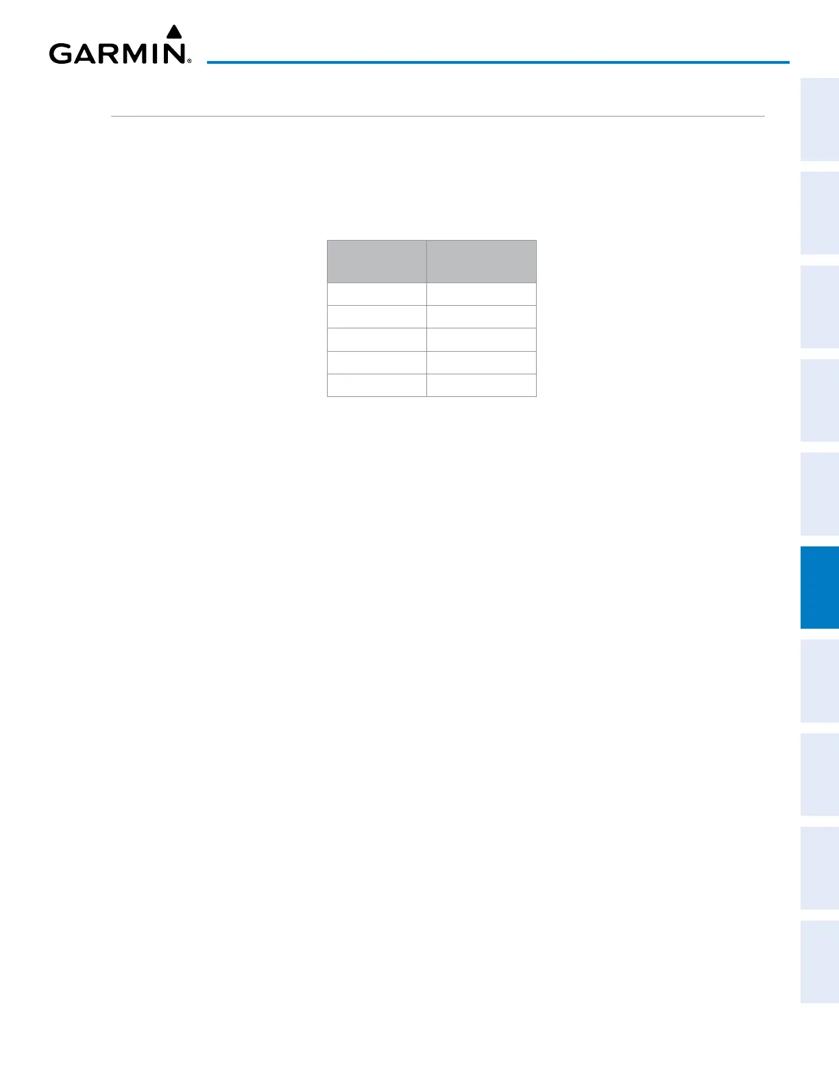
The contents of the Profile View Window are based on the current aircraft track (or heading if track is
unavailable), and the system shows the highest known terrain or obstacles within a predetermined width from
the present position to the end of the profile range inside the Profile View Window. This width is determined by
the phase of flight, as annunciated on the HSI, and is widest during enroute and oceanic phases, and narrowest
during approach and departure phases.
Flight Phase
Total Profile
View Width
Approach 0.6 nm
Departure 0.6 nm
Terminal 2.0 nm
Enroute 4.0 nm
Oceanic 4.0 nm
Table 6-19 Profile View Width Scale
The Profile Path display is a visual cue which represents the horizontal and lateral boundaries of the Profile
View on the MAP - NAVIGATION MAP Page. This path is depicted as a white rectangle and is only available
when Profile View is enabled. White range markers both edges of the Profile Path match the range markers
along the distance scale inside the Profile View Window. The Profile View distance must be at least four
nautical miles (or 7.5 km if configured for metric units) in order for the path display to appear on the MAP -
NAVIGATION MAP Page.
The pilot can enable or disable the Profile Path display on the Navigation Map. The pilot can also select
the maximum navigation map range to show the Profile Path. If a map range is selected beyond the selected
maximum range, the system removes the Profile Path display.
Customizing the Profile Path display on the MAP - NAVIGATION MAP Page:
1) Select the MAP - NAVIGATION MAP Page.
2) Press the MENU Key.
3) With ‘Map Setup’ highlighted, press the
ENT
Key.
4) Turn the small FMS Knob to select the ‘Profile’ Group and press the ENT Key.
5) Turn the large
FMS
Knob or press the
ENT
Key to scroll through product selections.
• PROFILE PATH – Turns the display of the Profile Path on or off and sets maximum range at which Profile Path
is shown
6) Turn the small
FMS
Knob to scroll through options (ON/OFF, range settings).
7) Press the
ENT
Key to select an option.
8) Push the FMS Knob or CLR Key to return to the MAP - NAVIGATION MAP Page with the changed settings.
 Loading...