Do you have a question about the Garmin GIA 63W and is the answer not in the manual?
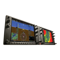
Overview of the G1000 Integrated Avionics System in the Piper PA-32 Saratoga.
Details LRUs like GDU 1040, GMA 1347, GIA 63W, GDC 74A, GEA 71, GTX 345R, GRS 77, GMU 44, GDL 69A SXM, GA 55.
Information on using SD cards for databases, software updates, and flight data recording.
Procedures for avionics power application and emergency power supply operation.
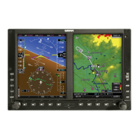
Discusses Normal and Reversionary display operations, AHRS modes, and system annunciations.
Details PFD/MFD controls, softkeys, and their functions for system operation.
Explains how to navigate menus, enter data, and access system functionality.
Covers manual and automatic adjustment of PFD/MFD display and key backlighting.
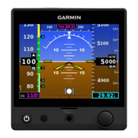
Describes the Primary Flight Display (PFD) with airspeed, attitude, altitude, and course deviation.
Details temperature, wind data, and Vertical Navigation (VNV) indications displayed on the PFD.
Explains SVT as a visual enhancement for topography and obstacle display.
Covers marker beacon annunciations, altitude alerting, low altitude, and minimum altitude alerts.
Discusses abnormal GPS conditions and heading failure modes affecting instrument displays.
Shows graphical display of engine parameters like manifold pressure, RPM, fuel, oil, and temperatures.
Details engine softkey functions for normally aspirated and turbocharged engines.
Explains EIS display in reversionary mode, including Lean and System displays.
Introduces the CNS system, audio panel, comm radios, nav radios, and Mode S transponder.
Covers COM tuning boxes, manual tuning, quick-tuning 121.500 MHz, and auto-tuning.
Details NAV radio selection, activation, manual tuning, and auto-tuning frequencies.
Explains transponder controls, mode selection, and code entry.
Covers intercom, passenger address, speaker, and entertainment inputs.
Provides steps for setting the audio panel during preflight checks.
Discusses stuck microphone, COM tuning failure, and audio panel fail-safe operation.
Overview of the integrated system and flight management using GPS sensors.
Details selecting, creating, and editing user waypoints, including airports, intersections, NDBs, VORs, VRPs.
Discusses display of various airspace types like Class B, TMA, Class C, CTA, Class A, Class D, Restricted, MOA.
Covers selection and activation of direct-to navigation for waypoints and airports.
Explains building flight plans, entering waypoints, modifying them, and managing flight plans.
Details vertical path guidance and altitude constraints for enroute and terminal phases.
Covers loading, activating, and removing departures, arrivals, and approaches.
Explains weight and fuel planning calculations, including payload and fuel statistics.
Details viewing trip planning information, fuel, and statistics based on automatic or manual data.
Discusses Dead Reckoning (DR) Mode when GPS is unavailable.
Explains SiriusXM Weather information, activation, and using weather products.
Covers FIS-B weather data, display options, and status.
Details Stormscope lightning display, cell/strike modes, and clearing data.
Explains displaying terrain and obstacle data, colors, symbols, and alerts.
Covers Terrain-SVS features, limitations, and display options.
Details TAWS-B operation, alerts, and system status.
Explains displaying terrain and obstacles in Profile View on the Navigation Map.
Discusses TIS operation, symbology, alerts, and system status.
Explains ADS-B system overview, automatic dependent surveillance-rebroacast (ADS-R), and ADS-B with TAS.
Details flight director mode annunciations and altitude preselect functions.
Explains SafeTaxi feature for detailed airport taxiway and runway information.
Describes using Jeppesen terminal charts, softkeys, and chart options.
Covers FliteCharts terminal procedures charts, softkeys, and selecting charts.
Details activating SiriusXM services and using XM Radio features.
Covers accessing and navigating electronic checklists, including emergency procedures.
Discusses troubleshooting SiriusXM data link receiver failures.
Explains CAS window, ALERTS window, softkey annunciations, system annunciations, and audio alerting.
Describes alert levels (warning, caution, advisory) and message prioritization.
Lists warning messages and their descriptions.
Lists caution messages and their descriptions.
Lists advisory messages and their descriptions.
Explains message advisory alerts and their display.
Discusses conditions that prevent CAS messages from being displayed.
Lists voice alerts and their triggers.
Provides detailed explanations for system message advisories.
Information on database updates, sources, and management.
Details updating the active and standby navigation databases.
Lists databases stored on Supplemental Data Cards.
Explains automatic transfer and synchronization of databases.
Instructions for updating basemap, SafeTaxi, obstacle, and airport directory databases.
Procedure for updating terrain, ChartView, and FliteCharts databases.
Glossary of aviation terms and acronyms used in the manual.
Addresses common questions about SBAS, RAIM, and approach operations.
Explanation of Satellite Based Augmentation System (SBAS) and its function.
Discusses how SBAS impacts LNAV/VNAV and LPV approach capabilities.
Explains Receiver Autonomous Integrity Monitoring (RAIM) and its effect on approach operations.
Defines Geodetic Sea Level (GSL) altitude and its calculation.
Explains why certain airports may not have published approaches.
Details how procedures are loaded into flight plans and stored.
Addresses the filing of "/G" for flight plans and GPS approach requirements.
Explains the function of the Omni-bearing Selector (OBS) softkey for manual waypoint sequencing.
Explains conditions that prevent automatic waypoint sequencing.
Describes manually selecting active legs within procedures.
Details pilot cues for turn anticipation and leg transitions.
Explains how CDI scale changes based on flight phase and approach activation.
Compares HSI response in OBS mode to VOR and explains CDI scale behavior.
Outlines missed approach procedures and MAP crossing implications.
Explains how to reactivate or activate new approaches after a missed approach.
| Brand | Garmin |
|---|---|
| Model | GIA 63W |
| Category | Avionics Display |
| Language | English |