Do you have a question about the Garmin Colorado Series and is the answer not in the manual?
Explains the primary input device for navigation and selection on the Colorado.
Guide for initial device setup, including language, time zone, and daylight saving selection.
Accessing shortcuts, marking, and navigating to waypoints.
Checking system status and adjusting screen brightness.
Accessing, zooming, panning, and reviewing map details.
Explains manual conventions, features, and optional accessories.
Provides contact information for customer support and technical assistance.
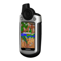
Labeled diagram identifying the physical components of the Colorado device.
Detailed steps for inserting batteries and turning the device on/off.
Guide on operating the Rock 'n Roller and basic device controls.
Checking status, adjusting backlight, and navigating lists.
Instructions for using the device's text entry interface.
Accessing shortcuts and understanding device profiles for usage optimization.
Steps for marking, saving, and managing location waypoints.
How to find and navigate to destinations using the Where To? menu.
Configuring search, navigating from map, and stopping navigation.
Accessing, zooming, panning, and reviewing map details.
Managing data fields and an overview of geocaching.
Steps to find and navigate to downloaded geocache locations.
Using the compass and calibrating it for accurate directional guidance.
Viewing elevation and pressure data over time or distance.
Using the trip computer to track travel data like speed and distance.
Configuring and managing track logs for recording journeys.
Accessing other apps and sharing data wirelessly between devices.
Viewing images and displaying topographical data in 3D.
Viewing celestial times and hunting/fishing predictions.
Creating and managing custom routes for navigation.
Viewing active routes and managing saved waypoints.
Setting alarms and using the device's calculator functions.
Using the stopwatch with lap timing capabilities.
Viewing GPS accuracy, satellite status, and elevation data.
Switching between profiles and calculating geographical areas.
Configuring core system settings like GPS mode and language.
Adjusting screen settings and customizing the Shortcuts menu.
Editing profiles and customizing map display settings.
Specific map modes and configuring track log recording.
Setting routing preferences and marine-specific configurations.
Configuring time format, time zone, and measurement units.
Setting position format, heading, and altimeter configurations.
Calibrating the device and connecting fitness sensors.
Technical details on device dimensions, performance, accuracy, and power.
Steps to connect via USB and transfer data to a PC.
Instructions for inserting and removing an SD card for storage.
Procedures for transferring and removing files from the device.
Steps for attaching and detaching the carabiner clip for carrying.
Terms of software use and regulatory compliance statements.
Potentially hazardous situations and safety guidelines for device use.
Information on map data accuracy and regulatory compliance.
Compliance details and warranty terms for the product.
| Battery Life | Up to 15 hours |
|---|---|
| Water Rating | IPX7 |
| High-sensitivity Receiver | Yes |
| Interface | USB |
| Barometric Altimeter | Yes |
| Waypoints | 1000 |
| Routes | 50 |
| Track log | 10, 000 points, 20 saved tracks |
| Display Type | Color TFT |
| Battery Type | 2 AA batteries |
| Electronic Compass | Yes |
| Memory | Internal memory |
| Wireless connectivity | Yes (Colorado 400t/400i only, unit-to-unit) |